|
Hutton
Roof to Burton-in-Kendal
Starting point and OS Grid reference:

Roadside
parking at St John’s Church, Hutton Roof (SD 570788)
|
Ordnance Survey Map
OL7
The English Lakes – South Eastern Area.
Buy this map from
List
of OS Maps
Note: If you use OS Maps on-line, you can download this route via this
link.
| |
Distance: 9.75
miles
|
Date of Walk: 20 February 2013
| |
Ascent:
Descent:
See Walking Time Calculator
|
429m (1406ft)
429m (1406ft)
| |
Traffic
light rating: 

(For explanation see My
Walks page)
| |


For advice on .gpx files see
My Walks page
|

Click
the PDF logo above to give a printable version of this walk without the
photos.
|
To
view route as a dynamic Ordnance Survey map click here.
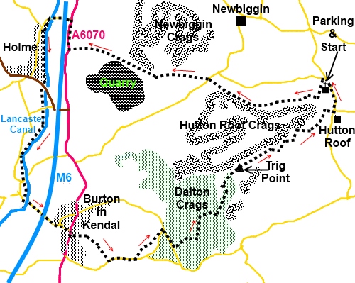
Introduction:
“Hutton Roof” is the curious name
on a road sign I had seen many times on the A65 en route to the Lake
District. I had long determined to see what was there and walk a route in
that area. Hutton Roof is a small village mostly of old stone cottages and
to be honest, little else. It is a quiet spot, minding its own business. To
its west however is a limestone plateau of crags and limestone pavements
combining Hutton Roof Crags and Dalton Crags. From its top there are
spectacular views in clear weather (unfortunately not very clear when I
recorded this walk!). The walk is in the very south western area of Cumbria.
My route starts from St John’s Church
Hutton Roof (where there is a small amount of roadside parking) and circles
the plateau taking in a section of the Lancaster Canal and Burton-in-Kendal.
However, this is a circular walk, it could be started at any convenient spot
on the circle.
Refreshment opportunities are limited and the
Kings Arms in Burton-in-Kendal is probably your best bet. There are also a
number of benches along the Lancaster Canal which make a convenient place
for a picnic.
The walk includes a section through Open
Access Land through a Forestry Commission woodland at Dalton Crags, where
the footpaths do not appear on any OS map but the route is very clear.
This is basically a very easy walk but there
is a section of moderately steep descent down from Dalton Crags hence the
amber traffic light above.
To get to Hutton Roof, turn south west off
the A65 at Kirkby Lonsdale or off the A6070 at Burton-in-Kendal (or start
there). Hutton Roof church is just under half a mile to the north of the
village.
Start:
Facing the church (SD 570788), turn right then left at the road junction,
signposted Clawthorpe and Burton. After a very few yards, turn left on to a
public footpath following the fingerpost for “Hutton Roof Crags”.
Follow the path to a stile, after which it
forks. Take the right hand fork and the path climbs. As you reach the top of
a rise (not the ultimate top), keep straight on ignoring the path off to the
left. On a clear day there will be great views across to the Lune Valley and
beyond.
%20Hint%20of%20the%20view%20over%20the%20Lune%20valley.jpg)
Almost at the top of the plateau, the path
forks again. Take the right fork to follow the valley.
The path starts to descend gently and you
come to a fork. Keep right and when reaching a kissing gate, cross the road
(SD 552788) and take the path opposite following the fingerpost for “Holme
Park” and “Limestone Link” - take the left hand path when it splits -
the one which briefly is parallel with the power lines.
%20Limestone%20pavement.jpg)
At a little rocky outcrop, the path forks and
you want the right leg. At another outcrop shortly afterwards, the path goes
to its right also and at this point you should see a walkers’ gate with a
yellow arrow.
Go through the gate on to National Trust land
- Holme Park Fell - and take the left hand track following the line of trees
and passing a quarry.
You pass a semi-buried stone construction
which is on the right, an old lime kiln.
%20Old%20lime%20kiln%20by%20yhe%20path%20%20on%20Holme%20Park%20Fell.jpg)
%20Unusual%20rock%20on%20Holme%20Park%20fell.jpg)
Stay on the broad track as it descends and
becomes more stony, until it reaches the road (A6070), then turn right (SD
530793). This is quite a fast road so take care and use the verge where you
can. The prominent hill to the immediate right is Farleton Fell.
%20Farleton%20Fell.jpg)
Follow the road for a quarter of a mile
before turning left signposted for Holme and Milnthorpe, to pass under the
motorway. Cross over the Lancaster Canal, then turn left to follow the
towpath following the fingerpost for “Holme Mills”. It is along here
where there are a number of benches useful as picnic stops.
%20Lancaster%20Canal.jpg)
You now follow the towpath for 1¾ miles,
passing under a number of canal bridges. At one point, the canal crosses
over a road on a high aqueduct and after this at the next road, look out for
some steps on the right hand side descending to that road (SD 523570). Turn
right along this road into Burton-in-Kendal.
%20Old%20road%20sign.jpg) On reaching Main Street (actually the A6070) at a ‘T’
junction, turn right. Look out for the Royal Hotel on the left (closed at
the time I did the walk, so may change its use). Shortly after this is the
market cross bearing a plaque recording that King Charles II made this a
market town in 1661. Turn left immediately before the cross, passing between
the buildings (SD 530764).
On reaching Main Street (actually the A6070) at a ‘T’
junction, turn right. Look out for the Royal Hotel on the left (closed at
the time I did the walk, so may change its use). Shortly after this is the
market cross bearing a plaque recording that King Charles II made this a
market town in 1661. Turn left immediately before the cross, passing between
the buildings (SD 530764).
Follow the track straight ahead through a
long narrow field (where the power poles start). At the top of the field,
there is a footpath off to the left which is not our route but it marks the
point (SD 533764) where you go diagonally right to the opposite corner of
the next field and through the kissing gate. Cross the next 2 field
diagonally also and go down to the road. Turn left here (SD 536760).
After about ¼ mile, just past the lodge
house which is on the right hand side of the road, look out for a public
footpath fingerpost on the left for “Dalton” and turn off here (SD
540761). Aim for the wide gap between the clumps of trees. Keep straight
ahead to a rough stone stile in the corner (to the left of the power pole
with the transformer).
When you get to Rose Cottage, the path
partially circles it anticlockwise. Follow the path through the trees and
turn right at the road (SD 544765). Keep left
at the fork in the road you arrive at immediately.
Walk along the road but in less than ¼ mile,
look out for a double 5 bar gate entrance on the left with a kissing gate
alongside. A notice tells you that this is Open Access land (SD 546763). The
next section of the walk does not appear as public footpaths on the OS maps
but there is a very clear, broad track through the trees which you follow.
Just stick to the main track. In particular, ignore a path which goes off to
the right at some crags.
Limestone pavement starts to appear amongst
the trees on the right. Not long after this, the main track splits. Take the
right fork which is the obvious main track. A short distance later, the
track forks again and this time, go left. It bends left as it exits the
trees and leads to a walkers’ gate. Through this, go straight ahead.
The track leads to the trig. point (SD
556774), with great views in all directions.
%20Trig%20point%20on%20Hutton%20Roof%20plateau.jpg)
Several paths much fainter than the approach
run from the trig. point but looking from the direction in which you
approached, the correct one is at about one o’clock (or at about 68°
magnetic if using a compass).
%20Another%20hint%20of%20views.jpg)
Keep descending and you should reach the
corner of two walls at SD 561777. The last part of the approach to this is
not very clear but if you miss it, you are likely to find your way blocked
by a wall, in which case turn left and follow it along to the corner –
rough going though!
From the corner, follow the path down
alongside the wall (wall on your right). You reach an unconventional stile,
part ladder and part stone stile. Do not cross it but turn left here. Walk
along until coming to a path on the right which goes quite steeply downhill,
following once again a wall on the right. You may now catch glimpses of
Hutton Roof through the trees.
As you come more or less level with the end
of the village, at a junction of paths, turn right and walk down to the
road. Here, turn left to follow the road the short distance back to the car.
If you need to buy any
hiking equipment/clothing before your trip see the Hiking
Store
All information on this
site is given in good faith and no liability is accepted in respect of any
damage, loss or injury which might result from acting on it.
|


.jpg)
.jpg)
.jpg)