
|
|
|
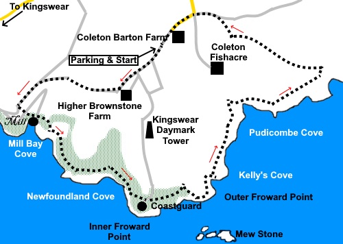
To view route as a dynamic Ordnance Survey map click here. Introduction: I have named this walk the Coleton Coves because I liked the alliteration and because there did nor seem to be any particular location to name it after. Coleton in these parts is most commonly associated with Coleton Fishacre, the fabulous National Trust gardens here. If you get chance, they are well worth a visit. There is also a Coleton Barton Farm close by. As far as I can establish, the name Coleton originates from a family name first found in Devon, where they became Lords of the Manor, following granting of favours by William of Normandy after 1066. This is a very pretty walk and the section through the pine trees, with the blue ocean behind (if you get a good day!) would do a Balearic island justice. There are also great views across the River Dart estuary. I did this walk in the late Spring and the seasonal flowers were in abundance - bluebells, primroses, garlic, and white daisies (Ox-Eye daisies I think) at least. There is a section of very steep steps down to Mill Bay and an equally steep section up again, to which I have allocated an amber symbol but once at Mill Bay, there is an interesting castellated ruin to see, though you cannot enter. This is a Grade II listed building which began life as a limekiln and was converted to a watermill and boathouse, in a mock castle style, in the 19th Century. There is a sand/shingle beach. After
the attractive walk along the cliffs, you arrive at the Coastguard Station,
now run by volunteers. From
here, there is a lower Coast Path which will take you down to see the
quite extensive Brownstone Battery, a
World War II coastal defence position. However, having seen similar
emplacements elsewhere, I did not bother with this descent but instead,
opted for the easier higher level Coast Path. There is an information point
just behind the Coastguard station which gives lots of information about the
Battery. Throughout much of the walk, you will have
sight of a curious octagonal limestone tower (see photos). This is the
Kingswear Daymark, built in 1864, to help guide ships into Dartmouth Harbour. A useful aspect of this walk is that it can
easily be shortened or lengthened, because if you look at the OS map, there
are various paths/lanes radiating out round the headland, from around
Coleton Barton Farm. The walk starts in a National Trust car park
close to the entrance to Coleton Fishacre. The chances are you will arrive
via the A379, either from the Kingswear ferry or from the Torbay direction.
Follow the National Trust signs for Coleton Fishacre. As you approach its
entrance, turn right and follow the lane for a quarter of a mile to the car
park. Start: Exit the car park (SX 904510) back on to the lane and turn left. Ignore the footpath leaving the car park by the information board. Follow the lane, arriving at a three way fingerpost. Continue down the tarmac lane following the fingerpost for “Kingswear 1½ miles”.
Pass the National Trust holiday cottage Higher Brownstone and immediately after it, turn right to follow its boundary wall, along a double concrete track. Just past another National Trust holiday cottage, (Crocker’s Cottage) keep straight ahead following the yellow arrow. After a fairly steep section, the path bottoms out and you come to a phone box. Turn left here following a public footpath fingerpost. At the road junction, turn left following a fingerpost for “Kingswear ¾” (SX 894507).
Just after the second lay-by, look for a fingerpost on the left (SX 892505) for “Coast Path” and “Inner Forward Point 1¼ miles". Turn left here. There is also a bronze plaque about Warren Woods. There now begins a long descent down many steps. You cross a private drive by a cattle grid. Continue down yet more steps. Eventually, at the bottom of the steps, arrive at a walkers’ gate. Continue through this to follow the coastal path. However before doing so, it is worth going through the five bar gate on the right to visit the cove and the old ‘castle-like’ mill building.
Through the walkers’ gate, climb a broad drive and just before a gate with a “Private no Public Right of Way”, turn left to follow the Coast Path fingerpost, climbing yet more steps. The route of the coast path is well marked and obvious. Follow it through the woods to Inner Froward Point and the cove, until you get to the Coastguard lookout point. From here, there is a lower Coast Path which will take you down to see the Brownstone Battery if you wish.
For the higher level route, take the drive from the Coastguard station, following the fingerpost for “HG Brownstone Car Park 1 mile”. Just before the gate into the Coastguard site, turn right at a three way fingerpost following the one for “Link to Coast Path and “Brixham 8½ miles”. You rejoin the Coast Path proper at a post with yellow arrows and the acorn sign at SX 905497. Continue following the obvious path. There are a few random paths here and there but the main path is fairly obvious.
At a three way fingerpost, turn left to follow the sign for “Coleton Car Park” (SX 918508). After a hundred yards or so, cross a stile next to a gate and follow the obvious path across the field in the direction of the yellow arrow. At the far side of the field, go through a kissing gate and follow the left hand boundary. At the end of that field, cross a stile to join a broad track and follow this to join another track at a three way fingerpost and continue straight ahead in the direction of “Coleton Fishacre” and “Brownstone”, crossing the car park. Out of the car park, turn left along the tarmac lane passing the entrance to Coleton Fishacre gardens. Keep straight ahead along the lane to return to where you have parked. If you need to buy any hiking equipment/clothing before your trip see the Hiking Store All information on this site is given in good faith and no liability is accepted in respect of any damage, loss or injury which might result from acting on it.
| | |||||||||||||||||

.jpg)
.jpg)
.jpg)
%20The%20lane%20from%20the%20car%20park.jpg)
%20View%20down%20to%20Mill%20Bay%20Cove.jpg)
%20Mill%20Bay%20Cove.jpg)
%20Castle%20at%20Mill%20Bay%20Cove.jpg)
%20View%20across%20the%20mouth%20of%20the%20river%20Dart.jpg)
%20Inner%20Froward%20Point.jpg)
%20Newfoundland%20Cove.jpg)
%20Mew%20Stone.jpg)
%20Coastguard%20Station%20Inner%20Froward%20Point.jpg)
%20Old%20Mill%20Bay.jpg)
%20Pudicombe%20Cove.jpg)