
|
|
|
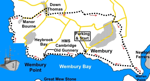
To view route as a dynamic Ordnance Survey map click here. Introduction: Looking for a different stretch of the Devon coast to walk on the Ordnance Survey map, my eyes alighted on “Manor Bourne”. It evoked memories of the old TV series starring Penelope Keith and acted as a spur to investigate. I actually expected some sort of historic house but when I got there actually found it to be a private estate of houses. The nearest approximation to a “manor” was a large mock Tudor edifice. Hey ho. However, that is not to detract from the general pleasure of this easy walk along the coast, affording good views, especially over Plymouth Sound where, if you are lucky, you might get to see the comings or goings of various naval vessels. To create a circular walk, it returns from Manor Bourne via country footpaths before giving the option to walk via Warren Point, seeing, en route, the River Yealm estuary. This is a beautiful spot and a highly recommended diversion. There are various benches along the coastal section where a picnic lunch can be enjoyed. The walk starts from the National Trust car park at Wembury. To get there, turn south off the A379 at Plymstock and follow the signs. Start: From the National Trust car park (SX 519485), walk west along the SW Coast Path (sea on your left) and drop down the little path and steps to the beach passing an information board about the old mill building (now a café).
Pass the public toilets, then follow the path along the rear of the beach, indicated by the public footpath fingerpost for “Heybrook Bay 1½ miles”. At SX 503484, if you drop down to the beach down an old slipway, are the fort-like remains of HMS Cambridge. A Royal Navy gunnery school where sailors practised shooting at a Rushton target, a substitute for an aircraft, which was towed behind a plane, hopefully on a long rope!
Out to sea, the pointed island you see is the Great Mewstone, now owned by the National Trust. It evidently gets its name from an Old English name for a herring gull. You will pass an information board which, amongst other things, tells of a criminal “transported” there as punishment, in 1744 for 7 years!
You arrive at Heybrook Bay (SX 497487), unremarkable in itself, although I was informed by a passer-by that there is a good pub there. The path crosses a stream and briefly passes along Heybrook Drive before returning to a more usual footpath at a two way fingerpost on the left – “Bovisands 1 mile”. View to Rame Head at the other side of the mouth of the River Tamar start to open up.
You reach a white painted navigation beacon (SX 491494). The path forks but keep to the coastal side.
At SX 491497, you arrive at Bovisands Park where there are a number of benches. Turn right here to follow the tarmac drive. Stay on it as it curves left then look out for a three way finger post on the right and turn right off the drive and up the footpath. It is tarmac initially, before going through a shrub/tree lined “tunnel”. The path opens into a private drive to Andurn. Turn right and follow this to the road by the Manor Bourne estate entrance.
At SX 500499, there is a footpath off to the right which will take you into the village of Down Thomas. However, I opted to stay on the road to the village and walk through its full length, partly just to have a look but also because I was hoping for a beer opportunity at the Mussel Inn. Sadly, this was closed and up for sale. If you have taken the footpath route to Down Thomas, you need to turn left along its main street and then right. If following the road, look out for an old chapel building on the left. The continuation of the route is along a footpath to its left, through a kissing gate and following a public footpath fingerpost. Cross a ‘V’ shaped stile and at a marker post with yellow arrows, turn left. Cross another stile then footbridge and keep straight ahead, following the yellow arrow. Reasonably obvious trodden turf and a series of visible stiles take you more or less in a straight line to the road. Cross over it to follow a fingerpost indicating “Footpath No. 17, Knighton 1¼ miles, Wembury Beach 1½ miles”. The significance of “No. 17” is not known. Follow the right hand boundary in the first field after the road and after crossing a stile in the corner, follow the obvious track. A yellow arrow on a post halfway down the field, just after passing under power lines, confirms the route.
Follow the track to the bottom of the dip and turn right after going through a gateway. There is a stream to your right. Follow it down until you reach the edge of the trees, where there is a substantial post bearing a number of arrows. Just past this, the path forks (SX 518499). Take the left fork, climbing the hill. You can curtail the walk here by taking the right fork directly back to Wembury and the car park. To continue to the River Yealm, follow the climbing path to a stile and beyond this, follow the right hand field boundary of the next two fields. In the third field, head for the diagonally opposite corner. This was clear and well walked when I did the walk. Cross a stile in the corner and after five or six yards, turn left to follow a yellow arrow. Follow the clear track across the first field and in the next, bear right to the diagonally opposite corner. At the road, turn right. At the road junction by the Old Wheel pub, turn left for about a hundred yards. Opposite the Post Office, follow the footpath indicated by the fingerpost. The first section is tarmac. At the ‘T’ junction of paths, turn left and after a few yards, turn right up some steps, to follow a finger post for “Allotments”. At the end of the allotments, keep straight on through two kissing gates and straight ahead on the obvious path across the field which follows the course of a wall on the left. At the lane, turn right to follow it. Do not follow the fingerpost for “Brownhill”. There are views here across to Dartmoor.
When the lane bends right, carry straight on following the National Trust sign for Warren Point. At a gate, you carry straight ahead drop down the River Yealm but return to this gate to then turn left to follow the more direct coast path, as I did. At SX 530481, fork right and follow the path back to the car park.
You can also turn right to follow the coast path along the river to Warren Point itself, before continuing back to the car park. If you need to buy any hiking equipment/clothing before your trip see the Hiking Store All information on this site is given in good faith and no liability is accepted in respect of any damage, loss or injury which might result from acting on it.
| | |||||||||||||||||

.jpg)
.jpg)
.jpg)
%20Wembury%20Beach.jpg)
%20Old%20HMS%20Cambridge%20Gunnery.jpg)
%20Great%20Mewstone.jpg)
%20Looking%20back%20towards%20Wembury.jpg)
%20View%20to%20Rame%20Head.jpg)
%20To%20the%20manor%20bourne.jpg)
%20Approaching%20Wembury.jpg)
%20View%20to%20Dartmoor.jpg)
%20Mouth%20of%20River%20Yealm.jpg)
%20Boats%20on%20the%20River%20Yealm.jpg)