
|
|
|
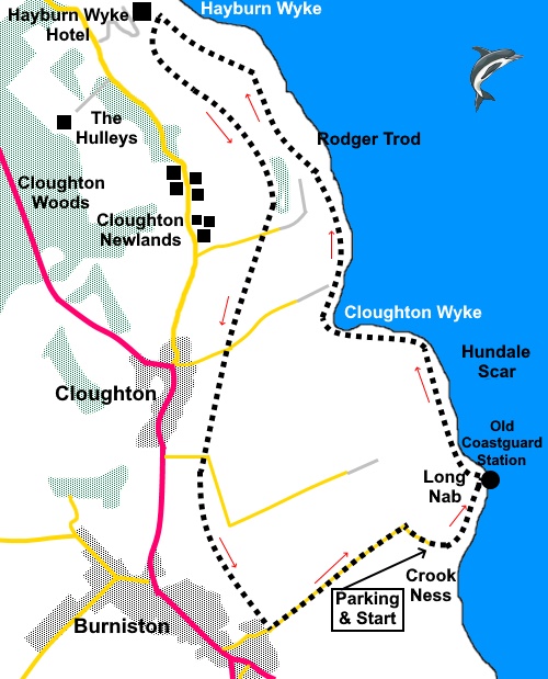
To view route as a dynamic Ordnance Survey map click here. Introduction: This walk starts in East Yorkshire, a matter of yards outside the North York Moors National Park though almost its entirety is within it. I therefore list it under both areas. The walk is a relatively easy walk along part of the Cleveland Way following Yorkshire’s coast and returning via the ‘Cinder Track’. The Cinder Track is the course of the old Scarborough to Whitby railway, which used cinders as the base for the tracks. It is in very good condition, which means you have to watch out for cyclists! Unlike some old railway routes, this is an attractive walk with good views. There are some steps down at Hundale Scar, Cloughton Wyke and Hayburn Wyke and a fairly steep climb to Hayburn Wike, hence the amber traffic light. A ‘Ness’ is technically a rocky promontory or headland although in this instance, one could be forgiven for thinking Crook Ness refer to the ravine access to the rocky foreshore. Back in Victorian times, stone was gathered here for road building. The rocks date back to the Jurassic period and fossils can be found on the beach. ‘Nab’ also refers to a promontory and from Crook Ness, the walk follows the coast to Long Nab. Here a white painted former Coastguard Station has been taken over by Scarborough Birders for bird watching and study of migration. In its original guise, it was to look out for mines and torpedoes indicating the presence of enemy submarines in WWII. The route then continues along the coast passing a few interesting names on the map, not least Roger Trod, the origin of which seems a mystery. The next major feature is the sandstone ‘pavement” of Hundale Scar before Cloughton Wyke. This indentation in the coast is a good place for fossil hunting although it is not an easy descent to the shore. Next is Hayburn Wyke, ‘Wyke’ incidentally being a Norse word for creek or sea inlet and indeed there is a creek dropping over a pleasant waterfall into a pool on the beach. ‘Hayburn’ is an old English word meaning a hunting enclosure by a stream. There is a pleasant, rocky beach and pleasant woodland. As a bonus, as you reach the Cinder Track for the return, you can enjoy refreshment at the Hayburn Wyke Inn! As with all this Yorkshire coast, take care not to get too close to the edge of the crumbly cliffs and if exploring the beaches, watch out for the tides. The walk starts at a little known free car park at Crook Ness. To get there, turn of the A171 at Burniston, on to Rocks Lane, next to the Three Jolly Sailors pub. Stay on this lane as it becomes Field Lane and follow it to its end. After rounding a sharp right hand bend, the car park is on the right. Start: From the parking area, walk in the same direction that you approached it, following the left hand public footpath indicated by fingerpost and passing an information board.
When the path splits again, take the left hand fork for a look at the foreshore at Crook Ness. Note some steps on the left as you descend. After inspecting the foreshore, return and ascend these steps, following the fingerpost for “Cleveland Way” and “Ravenscar 6½ miles”. Turn right at the top of the steps. Pass the old Coastguard Station at Long Nab (TA 029940).
Descend steps at Hundale Scar and cross a footbridge to continue following the coast path.
At TA 020952 pass a three way fingerpost where the left hand pointer is to Cloughton ¾ mile. Ignore this and continue on the coast path. Cross a small stream at TA 020955 where there is a similar fingerpost to the last. Ignore this too. Beyond here you start to get good views behind you to Scarborough and the castle is clearly visible (sea frets permitting!).
Descend steeply to Hayburn Wyke through the trees.
Arrive at a three-way fingerpost indicating the onward route of the Cleveland Way and left to the Hayburn Wyke Inn. Turn right to follow the path down to see the beach, then return to follow the path to the inn. This is now a bridleway which you follow through two gates Follow the track, passing a car park on the left. As you reach the pub, the track doubles back on itself. Follow it to reach the Cinder Track, which you cross after rounding a bend. Turn left along it, indicated by the unusual signpost pointing to Scarborough.
It should now be plain sailing to follow this back to Field Land which you then follow back to the car. However as I found, it is quite easy to lose track of where you are on the Cinder Track, especially if you are chatting and I very nearly overshot, so a few pointers. Pass but ignore a fingerpost on the right for “Cloughton” and “Newlands Road ½ mile” at TA 015955.
Pass but again ignore another fingerpost for “Cloughton ¼ mile” at TA 013949. Shortly after that, you pass under a road bridge at TA 013948.
At TA 012941 reach a road by another of the unusual marker posts. Turn right and immediately left to rejoin the Cinder Track. Pass the old Cloughton station building and when the track forks, keep left. As you get to the gate, look back and to the right. You will see Oscar, an old railway carriage set between the old platforms, let as self catering holiday accommodation.
You now reach the outskirts of Burniston. Keep a close look out for the low stone bridge walls where the Cinder Track goes over a road at TA 016931. These were mostly obscured by vegetation. Descend steps here, after crossing the bridge, to the road. Cut back under the bridge and follow the road back to the parking spot. If you need to buy any hiking equipment/clothing before your trip see the Hiking Store All information on this site is given in good faith and no liability is accepted in respect of any damage, loss or injury which might result from acting on it.
| | |||||||||||||||||

.jpg)
.jpg)
.jpg)
%20Foreshore%20at%20Crook%20Ness.jpg)
%20Approaching%20the%20former%20coastguard%20station%20at%20Long%20Nab.jpg)
%20View%20along%20the%20coast%20N%20from%20Long%20Nab.jpg)
%20Looking%20Back%20at%20Long%20Nab.jpg)
%20Approaching%20Cloughton%20Wyke.jpg)
%20Hundale%20Scar.jpg)
,%20Orchids%20at%20the%20steps%20to%20Cloughton%20Wyke.jpg)
%20Wild%20Campion.jpg)
%20Approaching%20Hayburn%20Wyke.jpg)
%20Looking%20down%20on%20Hayburn%20Wyke.jpg)
%20Beach%20pool%20at%20Hayburn%20Wyke.jpg)
%20One%20of%20the%20unusual%20signs%20on%20the%20Cinder%20Track.jpg)
%20View%20from%20the%20Cinder%20Track%20to%20Scarborough%20Castle.jpg)
%20Looking%20Along%20the%20Cinder%20Track.jpg)
%20Railway%20carriage%20accommodation.jpg)