|
Settrington
Circular
|
Starting
point and OS Grid reference:

Settrington Village Hall car
park (SE 833707) (small charge)
|
Ordnance
Survey Map
OS
Explorer 300 – Howardian Hills and Malton.
Buy this map from
List
of OS Maps
Note: If you use OS Maps on-line, you can download this route via this
link.
| |
Distance: 10
miles
|
Date of Walk: 18
February 2015
| |
Traffic light rating:

(For explanation see My
Walks page)
| |


For advice on .gpx files see
My
Walks page
|

Click
the PDF logo above to give a printable version of this walk without the
photos.
|
To
view route as a dynamic Ordnance Survey map click here.
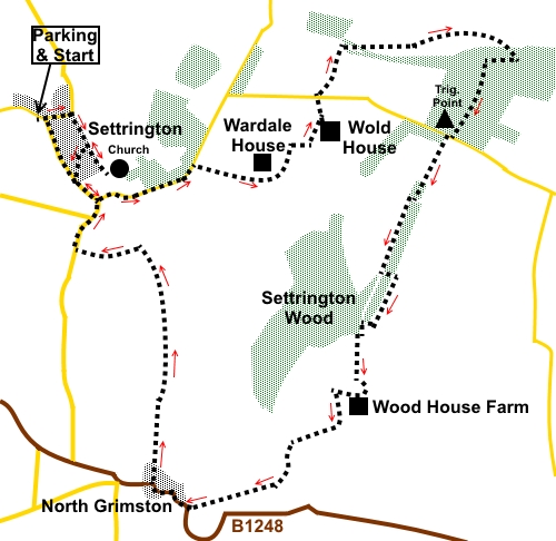
Introduction: This
walk from Settrington takes you on an easy ramble across undulating
countryside on the edge of the Yorkshire Wolds. It rises gently to
Settrington Beacon on the ridge at Thorpe Bassett Wold, in the process
providing far reaching retrospective views over the Vale of York. From
Thorpe Bassett Wold, equally impressive views appear over the Vale of
Pickering to the North York Moors and the Howardian Hills.
Settrington
itself is a very pretty village with Settrington Beck running down its
centre and a ford at its centre. It has a long history and was mentioned in
the Domesday Book. As part of the Settrington Estate (which seems to own
most of the land hereabouts judging from notices), the village was
extensively redeveloped at the end of the 18th century but its
centre has remained largely unchanged since.
The
13th century village church of All Saints is in a lovely
picturesque setting, next to Settrington House and this walk route does a
small diversion at the start to have a look.
The
walk also passes through the village of North Grimston. This lacks some of
the character of Settrington but on the plus side does have a pub, the
Middleton Arms, which may be able to provide sustenance during your walk
(check opening times).
There
is also a handy bench for a picnic part way round.
The
walk starts from the village hall car park at Settrington. Small charge. To
get to Settrington, turn south off the A64 just to the east of Malton
(signposted).
Start: Turn
right out of the village hall car park (SE
833707). Cross the bridge over the beck and continue to the bend in
the road where you turn right following the road sign for Settrington
Church.
%20Beck%20through%20Settrington.jpg)
%20Village%20church%20Settrington.jpg)
After
viewing the church, retrace your steps and turn left at the first road
junction, following the Yorkshire Wolds cycle route.
At
the next junction, turn left to follow the course of the beck. Cross it via
the footbridge then bear left to the “main” road. Turn left here.
As
the “main” road bends right just outside the village, turn left
following the road sign for “Settrington House” and “Lutton 7 miles”
(SE 838701).
%20Lake%20at%20Settrington.jpg)
Walk
up this road for half a mile, passing a lake and the entrance to Low
Bellmanear Farm (ignoring the public footpath sign). As you near the top of
the hill, turn right at the entrance to Wardale House, following the public
footpath sign (SE 846703). There are good views south here.
%20View%20south.jpg)
Follow
this track, more or less in a straight line, for a quarter of a mile and
when it turns sharply left, turn off over a stile (SE 850702), following the
yellow public footpath arrow.
%20View%20towards%20Settrington%20Beacon.jpg)
The
path curves left, roughly following the edge of the trees. When you get to
the point where the edge of the trees turns left, head downhill to where
there is distinct corner of the stream. Cross the stream to the left of a
pond (SE 854705), following a yellow footpath arrow and head uphill, keeping
to the left hand field boundary.
Go
through a gateway at the top of the field and turn left. There is a distinct
dome shape to this field and you need to keep between the small copse of
trees and the left of the top of the dome. You soon come in sight of Wold
House. Continue up the hill keeping well to the left of the house until you
see an old building with a curved roof. Cross the stile next to this and
turn right to follow the yellow arrow (SE 856707).
On
reaching the drive to Wold House, turn left and follow it to the road. Cross
the road and follow the footpath arrow opposite, bearing right at about 45°
to the road.
As
you get to the far edge of this field, you get good views over the Vale of
Pickering to the North York Moors and Howardian Hills. Keep straight ahead
to the left of the hedge at the next field.
%20View%20North%20over%20the%20Vale%20of%20Pickering.jpg)
At
the bottom of the field, keep to the right of a ruined building and turn
right on the path through the trees. After less than 200 yards, exit the
trees via a gate (SE 859703), then, bear right at about 45° following the
bridleway arrow, along a broad, gradually descending track.
%20Looking%20North%20over%20the%20vale%20of%20Pickering.jpg)
You
follow this track for just under a mile as it curves gradually right and
ignoring any paths off to the left. You pass to the left of an old quarry
and not far after this, come to a fingerpost. Bear right following the Wolds
Way/Centenary Way fingerpost.
The
path starts to climb gently to the trees. Just before the trees is a
scenically placed bench, ideal for a sandwich stop with a view (SE 871713).
Go
through the kissing gate into the trees and follow the clear path until it
meets a broad track after 100 yards or so. Turn right here following the Wolds
Way/Centenary Way which is your guide for a while now, until just after Wood
House Farm. Follow the track to the road, passing the trig. point (SE
867706) and at the road, go straight over, once again following the Wolds
Way/Centenary Way sign with the addition of “Wharram le Street 3½ miles.
%20Trig%20point%20at%20Settrington%20Beacon.jpg)
Stay
on this broad track for two miles, passing eventually through the farmyard
of Wood House Farm. From here, it becomes a tarmac drive. Follow the tarmac
ignoring any turns off (The Wolds Way/Centenary Way leaves you at SE 857682,
just after a cattle grid), until you reach the road (the B1248) at North
Grimston. Turn right. Take care here as this is quite a busy road.
Fortunately, you only follow the road for a quarter of a mile, round the
‘S’ bends and passing the pub.
%20View%20near%20North%20Grimston.jpg)
Cross
the stream and turn right along a clear drive by a walled garden following a
fingerpost for Centenary Way.
Opposite
the entrance to the old vicarage, fork off right over the stone step stile,
following the yellow arrow. Head for the diagonally opposite corner of the
field and go through a kissing gate and over a stile. Follow the left hand
boundary in this next field.
At
the entrance to Bellmanear farm, turn left and almost immediately right over
a stile. The footpath is then to the right of the fence.
The
path roughly follows the left hand side of the stream, although the stream
meanders somewhat. Follow the path to Kirk Hill where you cross the stream
via a small footbridge. Go through a kissing gate by the house and turn left
along the drive.
At
the road, the building which was the old Settrington station (now a private
house) and the route of the line can be discerned. It closed in 1958. Turn
right along the road, back to Settrington.
If you need to buy any
hiking equipment/clothing before your trip see the Hiking
Store
All information on this
site is given in good faith and no liability is accepted in respect of any
damage, loss or injury which might result from acting on it.
|


.jpg)
.jpg)
.jpg)