
|
|
|
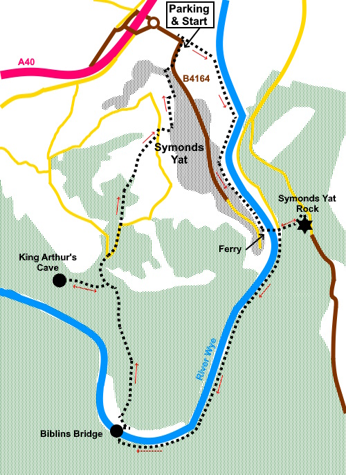
To view route as a dynamic Ordnance Survey map click here. Introduction: This walk from Symonds Yat follows the course of the
River Wye. The valley here is forested. The route diverts to Symonds Yat
Rock, an internationally renowned viewpoint from which there are spectacular
views along the valley. The rock is also well known as a nesting site for Peregrine
Falcons andf other birds of prey. The valley and the rock are well known beauty spots and very popular so it is unlikely you will have any of it to yourself, particularly on weekends or at holiday periods. The river itself is popular with canoeists. It is a very picturesque area, so its popularity is not surprising. In the 18th century, a boat trip down the River Wye was an alternative to the European Grand Tour. Symonds Yat is split into east and west sections by the River Wye. They are linked by ferry, footbridge or a long drive! The walk gives you the chance to experience an unusual crossing of the river by a ferry, hand hauled across via a suspended cable. It runs daily but not from November to April or possibly if conditions are unsafe. You can check if it is running by checking with YOFI Paddlesports. There is another similar ferry a quarter of a mile downriver run by the Saracens Head Hotel. The route then crosses back over the river via Biblins Bridge, a long suspension bridge and an iconic feature of the river. It has been damaged by floods on a number of occasions. Conditions are monitored by Forestry England and it is closed if safety decrees. The route passes through Lord’s Wood and gives you a chance to see King Arthur’s Cave. This was excavated in the 1800s and bones were found of various Ice Age animals. It is a cave in a low limestone cliff and worth a look. Start: From the parking area (SO 554174), return to the entrance turn right to follow a fingerpost for “Riverside Walk & Symonds Yat East 1½ miles”. This is a tarmac lane which leads to the church.
Exit the church car park to the right of the church and arrive at the riverside walk. Turn right to follow the river. Note the path follows the river through the campsite.
Continue to the Old Ferry Inn and cross the river. Once over it, turn right, crossing a field.
Arrive at Symonds Yat East Riverside Car Park. Follow the road to the New Weir Car Park, passing the Sarecens Head Hotel and turn sharp left to follow a fingerpost for “Yat Rock ½ Mile”, in front of the Royal Lodge Hotel. Continue until you reach some rough steps, where there is a bench on the corner. Turn right up the steps, following a yellow arrow. Opposite a gate, there is a path on the right. Turn right here following a fingerpost for “Yat Rock”.(SO 562160). This leads to a wide track where you turn left and immediately right up some rough steps (SO 563169). After seeing the rock, return to this point, turning right to descend.
On reaching a broad path parallel with the riverside path, urn left. You will eventually find a spot where you can cross to the actual riverside path (SO 559154). Continue in the same direction. Pass a two way fingerpost and follow” Biblins Bridge) (SO554144). Cross Biblins Bridge and turn right along the broad track, following it around the left bend into the trees.
Just past a wooden chalet, the track splits. Take the right fork, ignoring a minor path into the trees. Pass and ignore another broad track which doubles back on the right and stay on the main track, which you follow for about three quarters of a mile. You will arrive at a car park where there are a couple of notice boards which tell you about the landscape and geology of the area and King Arthur’s Cave, which is worth a look.
To find the cave, follow the footpath behind the notice boards. The cave is less that a quarter of a mile from the car park at SO 545155. It is at the foot of a small limestone cliff. Return to the car park and turn left along the track. You will arrive at a road where there is a campsite with a café. Turn right along the road (SO 548157). Follow the road for about three hundred yards to where it bends sharply right. On the corner, ignore a footpath off to the left but take the broader track straight ahead Leaping Stocks Road (SO 549160).
Finding the route can now be a little tricky as there are a multitude of tracks/paths and the route is not easy to describe. If all else fails, once you leave Leaping Stocks Lane, virtually any downhill path will take you back to the B4164 where you turn left to return to the car park. However, my directions are - follow Leaping Stocks Road for about two hundred and fifty yards where it appears to fork. Follow the main track right. Arrive at another junction where there are a couple of properties, one of which is called Box Brush. Take the descending track to the right of this (SO 551166). At the next junction, the left turn is marked as a private road. Turn right. Arrive at a tarmac lane. Turn left (Mine Pits Lane). Follow this lane passing Wye View Lane. About a hundred yards beyond Wye View Lane, look out for a fingerpost on the left, pointing right and turn right on this footpath (SO 552168). There is a sign on a tree for “The Cot”. You get to two five bar gates and a fingerpost on the right. Turn left following the direction of the fingerpost down a narrow, sunken footpath.
Arrive at a tarmac lane and turn left. At the next junction, turn left. At SO 552172 turn right off the lane, along a narrow footpath between the trees. This is immediately before a rough parking area on the right. At the tarmac lane, turn left to return to the car park. If you need to buy any hiking equipment/clothing before your trip see the Hiking Store All information on this site is given in good faith and no liability is accepted in respect of any damage, loss or injury which might result from acting on it.
| | |||||||||||||||||

.jpg)
.jpg)
.jpg)
%20St%20Dubricius%20Church.jpg)
%20Canoes%20on%20the%20river%20Wye.jpg)
%20Hand%20pulled%20ferry.jpg)
%20Final%20steps%20to%20Symons%20Yat%20Viewpoint.jpg)
%20View%20from%20Sym,onds%20Yat%20rock.jpg)
%20Biblins%20Bridge.jpg)
%20King%20Arthurs%20Cave.jpg)
%20View%20from%20Leaping%20Stocks%20Road.jpg)
%20A%20sunken%20lane.jpg)
%20A%20view%20during%20the%20return.jpg)