
|
|
|
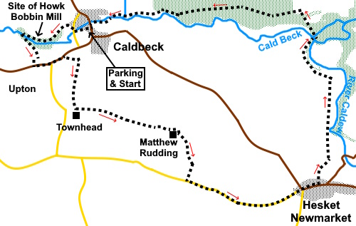
To view route as a dynamic Ordnance Survey map click here. Introduction: This walk from Caldbeck to Hesket Newmarket links these two attractive villages. It is a varied walk with industrial remains, waterside sections, pleasant views and at the time I did the walk, a good display of wild flowers. Overall, it is an easy walk apart from some steep steps early on and quite a steep bank after Watersmeet, beyond Hesket Newmarket. However nothing so severe as to warrant more than a green traffic light. Caldbeck is an attractive village, just inside the Lake District whose name is derived from Old Norse ‘Kaldr’ meaning cold and ‘Bekkr’ meaning stream or beck. It provided a centre for workers in the hill farming, lead, copper and coal mining and textile and bobbin making industries. It
has a fine church, St Kentigern’s and in the graveyard is the grave of
John Peel immortalised in a once famous but I suspect now largely forgotten
song “D'ye ken John Peel” (Do you know John Peel). He died in
1854. Peel was a huntsman with a pack of hounds, which will not endear him
to many these days! The song was written by his friend John Woodcock Graves.
The route does not set out to pass the church. You will have to hunt for it! It has a pub, the Oddfellows Arms. Quickly after leaving Caldbeck, the route runs through the Howk, a local dialect word meaning ‘scooping out’. In this context here, it refers to a narrow limestone gorge with a stream and waterfalls and various rare ferns. It also contains the ruin of Howk Bobbin Mill, one of over 100 such mills in the Cumbria at one time. This one provided employment for around 60 workers. It made wooden bobbins for the textile industry between 1857 and 1924 and was powered by a waterwheel, one of the largest in the country. As demand decreased, they diversified into other wooden items which could be turned. A substantial amount of the mill remains, the most stand-out item and best preserved perhaps being the timber seasoning shed. Hesket Newmarket sits on a terrace above the River Caldew. It has a long attractive village green with a road down each side and a market cross, or at least the roof structure under which it must have stood. There are a number of listed buildings. Its development is thanks to mining on the Northern Fells. The village has changed little since the middle of the 19th Century. It has a pub, the Crown Inn where Charles Dickens evidently stayed. ‘Hesket’ evidently comes from ‘Eskeheued’, from Old Norse ‘eski’ (ash - tree) and Anglo-Saxon ‘hēafod’ (ash-head) meaning in total ‘hill with ash trees on’. The ‘Newmarket’ part does what it says on the tin being down to the granting of a market charter in the early 18th Century. Well through the walk, the River Caldew joins forces with Cald Beck at Waters Meet, a local ‘landmark’ mentioned on at least one finger post. The walk starts from Caldbeck where there is a reasonable, honesty box car park, though you could start from Hesket Newmarket if more convenient. There are many routes to Caldbeck but the easiest to describe is to leave the A595 at Red Dial near Wigton and follow the signposted road. Start: Exit
the car park along a wide tarmac path (NY
324399) from the rear right hand corner opposite the main entrance where the
honesty box is. You soon reach a lane. Turn left. As the lane bends sharp left, keep straight ahead next to a row of cottages. There is a sign on the wall “Footpath to Howk”.
Follow the path through the trees, soon passing the ruins of the bobbin mill.
Beyond the mill, climb some steep steps and at the top, turn left to follow the stream.
Quickly cross a footbridge and then turn left and climb some steps. Follow the clear path to the road and turn left.
Pass the
edge of the hamlet of Upton, passing the junction and the school building.
Just after the last house, look out on the right for a public footpath
fingerpost and cross the stile. When I did the walk, a wide ‘passage’
was marked out with posts and ropes. This may not always be there or might
shift but has no relevance to the footpath route. You need to follow the
direction of the fingerpost to the far side of the field opposite the road. As you
crest the top of the field, you will see a walkers’ gate. Go through this
and turn right. Follow
the clear track until it enters a field where the route may become a little
indistinct. Head for the power pole in the field and continue in that line,
then following the right hand boundary. The path leads to a broad track (NY 322392). Turn left. The track becomes a tarmac lane and leads to Matthew Rudding.
The
route at Matthew Rudding is not clear. According to the map, the route
should be through the yard but this did not seem a viable option and may
have been diverted. I took the hint of the walkers’ gate next to the farm
gate ahead and then circled clockwise round the farm, up quite a steep bank. As you get round the farm, head for
the diagonally opposite corner of the field to where the farm sits. At this
corner are two gates, one at the corner and one to the left. Go through the
left hand gate, just to the left of a group of trees (NY 331388). There was
a yellow footpath marker on the right hand gate post. Turn right and follow the right hand boundary of the field to the road where you turn left to follow it into Hesket Newmarket. There are various benches where you can sit for a picnic and there is a post office/general store.
Walk
down the road to the left of the long green and turn left just after the
children’s playground following the fingerpost for “Waters Meet ¾
Mile”. The path leads to a walkers' gate. Keep left at the fork. The path
enters a rough field and shortly afterwards, there is a fork. The map
suggests you should go right then left in a dog leg but judging from the
well walked path, common practice is to keep left. This avoids having to
climb the incline at the far side of the field. If the
path becomes indistinct, keep to the top of the banking. In essence, you are
following the course of the River Caldew below you. Arrive
at a walkers gate (NY 340397) and through this, cross a footbridge. Beyond
the bridge various paths forged routes through the bracken and several are
marked on the map. I followed one straight ahead from the bridge. Don’t
get sidetracked on to the one passing to the left of a substantial picnic
table. The main used path I followed seems to be a black dotted line curving
left on the OS map, the Right of Way proper being buried in the bracken. It
does not matter too much which path you use as long as you keep climbing as
sooner or later you will meet another path crossing yours. This is the Cumbria Way, which at this point was not the well walked, well indicated path I expected for a supposed main route. Turn left along it.
It becomes more substantial as you progress and leads you back, via a campsite directly to the parking.
If you need to buy any hiking equipment/clothing before your trip see the Hiking Store All information on this site is given in good faith and no liability is accepted in respect of any damage, loss or injury which might result from acting on it.
| | |||||||||||||||||

.jpg)
.jpg)
.jpg)
%20Cottages%20on%20footpath%20to%20Howk.jpg)
%20Scene%20in%20Caldbeck.jpg)
%20Path%20en%20route%20to%20Howk%20bobbin%20mill.jpg)
%20Howk%20Bobbin%20Mill%20timber%20seasoning%20shed.jpg)
%20Inside%20the%20main%20building%20of%20Howk%20Bobbin%20Mill.jpg)
%20Waterfalls%20near%20Howk%20bobbin%20mill.jpg)
%20Looking%20along%20Cald%20Beck.jpg)
%20View%20across%20to%20the%20Caldbeck%20Fells.jpg)
%20Looking%20across%20the%20Cald%20Beck%20valley%20to%20Warnell%20Fell.jpg)
%20Vicia%20Cracca.jpg)
%20Market%20Cross%20in%20Hesket%20Newmarket.jpg)
%20Village%20Green%20in%20Hesket%20Newmarket.jpg)
%20Looking%20across%20to%20Carrock%20Fell.jpg)
%20St%20Kentigern's%20Church%20Caldbeck.jpg)
%20Grave%20of%20John%20Peel.jpg)