|
Langdale
Pikes
Starting point and OS Grid reference:

National
Trust pay and display car park near the New Dungeon Gill hotel (NY 294064)
|
Ordnance Survey Map
OL6
The English Lakes – South-western Area.
Buy this map from
List
of OS Maps
Note: If you use OS Maps on-line, you can download this route via this
link.
| |
Distance: 6.4 miles
|
Date of Walk: 9
May 2012
| |
Ascent:
Descent:
See Walking Time Calculator
|
868m (2847)
866m (2840)
| |
Traffic
light rating:


(For explanation see My
Walks page)
| |


or advice on .gpx files see
My Walks page
|

Click
the PDF logo above to give a printable version of this walk without the
photos.
|
To
view route as a dynamic Ordnance Survey map click here.
%20The%20Langdale%20Pikes.jpg)
Introduction:
No portfolio of walks in the Lake
District is complete without The Langdale Pikes walk. The distinctive shape
of their summits is visible from all over the area. This and their setting
above the gorgeous Langdale Valley make them a magnet for walkers. There are
a myriad of ways of tackling them and this route may not be the easiest but
provides something of a challenge. It is therefore quite a hard walk despite
its relatively short distance, involving a steep climb and steep descent.
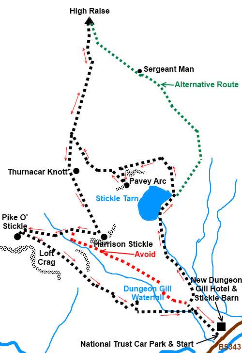
Some descriptions of this walk take a
sweeping curve to Sergeant Man, then, go along to High Raise, before coming
back to Harrison Stickle (see alternative route on the sketch map). This
misses out Pavey Arc which is a shame because the view almost vertically
down to Stickle Tarn is quite dramatic. I therefore include Pavey Arc but
omit Sergeant Man. Sergeant Man can be done as an offshoot from High Raise
if you wish.
The plateau on which the Pikes sit can be
quite a disorientating place in poor visibility although their relatively
lower altitude means they are often below the cloud cap when the bigger
fells have disappeared. It is nevertheless recommended that a compass and
map be carried plus of course the ability to use them!
The plateau is usually boggy in places and
gaiters are recommended, especially after any wet weather.
%20Sign%20at%20start.jpg) The walk starts from the National Trust car park
at the New Dungeon Ghyll Hotel. The adjacent Stickle Barn pub provides for
welcome refreshment afterwards! To get there, take the A593 out of Ambleside
and at Skelwith Bridge, turn right on to the B5343. The car park is on the
right after 4 miles. The walk starts from the National Trust car park
at the New Dungeon Ghyll Hotel. The adjacent Stickle Barn pub provides for
welcome refreshment afterwards! To get there, take the A593 out of Ambleside
and at Skelwith Bridge, turn right on to the B5343. The car park is on the
right after 4 miles.
Start:
From the car park (NY 294064), look out for the slate sign (see photo). Go over a
stile with a dog gate alongside and take the path up the hill, following the
wall on the left and ignoring the track through the gateway. Go through a
walkers’ gate then turn left through another gate then immediately right
to follow the wall now on your right.
After passing a bench, go over another stile
with a dog gate (see photo) and take note of this as you come back to this
on the return journey.
%20Stile%20marking%20return%20point.jpg)
Continue to follow the wall up the hill. When
the path splits, keep right following the wall until it swings right and
downhill. Head towards the waterfall and you will meet a path
“manicured” with stones coming, up from the valley (NY 291069). Turn
left here. The manicuring stops and the path becomes less clear but it is
just discernable. Continue to climb, gradually working your way over towards
the stream.
Follow the left hand bank of the stream until
you reach Stickle Tarn (NY 288075). The mass of Pavey Ark towers above.
There is a diagonal band rising up from bottom right left across the face.
This is Jack’s Rake which provides an alternative route to the top of
Pavey Arc via a severe scramble. This should only be attempted if you are
confident of your abilities and have no vertigo issues. Our ascent is more
restrained!
%20Stickle%20tarn.jpg)
Turn right at the tarn, crossing the stream,
and follow its edge. The path passes a large boulder on the right of the
path. At a cairn (NY 290077), the main (most worn) path bears left and you
should continue to follow it. (turning right here would take you on the
alternative route via a sweeping anti-clockwise path to Sergeant Man).
Our route now starts to climb steeply up the
right hand side of Pavey Arc.
%20Stickle%20Tarn%20during%20ascent%20of%20Pavey%20Arc.jpg)
On reaching the top, the path goes straight
ahead passing just to the left of a small tarn. Just after the tarn, bear
round to the left heading towards the top of Pavey Arc. You will notice some
old dilapidated sections of wall built on top of rocks. Head to the right of
the first prominent section of wall you see. There is then another prominent
section to the right. Pass between these sections actually crossing the wall
where it has collapsed.
%20Top%20of%20Pavey%20Arc.jpg)
After visiting the top of Pavey Arc (2297ft
700m) (NY 284079) with good views almost vertically down to the tarn, to get
to High Raise retrace your steps across the wall and go straight ahead. High
Raise is the left hand end of the grassy hill on the near horizon. The rocky
“lump” at the other end is Sergeant Man. There is a small irregularly
shaped tarn ahead (this may vary according to recent weather).
%20Looking%20across%20to%20High%20Raise.jpg)
After passing the tarn, bear left. You may
see a white post and to the right of this are the traces of the path. It is
a little indistinct. Pass to the left of a stone cairn built on top of rocks
and to the left of another small tarn. Follow the contour of the hill round
to the right and you should see a patch of stony ground across which the
path goes.
The route to the top of High Raise, across
the coll should be clear. The reaching of the stone built
trig. point indicates the summit at 2500ft (760m) (NY 281095).
%20Summit%20of%20High%20Raise.jpg)
From the summit of raise, retrace your steps
along the same path, heading towards Harrison Stickle, the left of the two
most prominent rocky hills on the near horizon. The prominent and
distinctive round shaped rocky hill to the right is Pike Of Stickle.
%20Approaching%20Harrison%20Stickle.jpg)
%20Pike%20O%20Stickle.jpg)
After passing two stone cairns on the right
and just before a third, look out for a faint grassy path on the right. This
path is indistinct but as you crest a rise (Thurnacar Knott on the map),
with a stone cairn, you see Pike Of stickle ahead and you should bear off
left to Harrison Stickle.
As you approach Harrison Stickle, there is a
rocky cliff in front of it on two levels. Head to the left of this and look
out for a cairn built on top of rocks. From this cairn (NY 2809076), the
path to the summit, initially to the left of the summit, is clear. At one
point it feels as if the path is about to descend but then it swings round
to the right with stone cairns marking the way.
%20Pavey%20Arc%20and%20Stickle%20Tarn%20from%20Harrison%20Stickle.jpg)
%20Looking%20down%20the%20Langdale%20Valley%20from%20harrison%20Stickle.jpg)
From the top of Harrison Stickle (2415ft or
736m) (NY 282074), head towards Pike Of Stickle (or Pike O’ Stickle). The
route down is marked by stone cairns and from the valley bottom, the path
straight ahead to Pike Of stickle is obvious.
There are various ascent routes of Pike Of
Stickle. Some scrambling is inevitable but having climbed one way and come
down another, in my view the easiest and with the least scrambling is
accessed by turning left off the main track about 200/300 yards after
leaving the valley bottom. It is a fairly obvious well walked path.
Enjoy the views from the summit (2326ft or
709m) (NY 274074) but before leaving, look across the valley and note the
obvious path bending round the base of Harrison Stickle. This catches people
out and is not
your way down. There is a black dotted path below Thorn Crag shown on
the OS map but a safer, better defined route is the one which does appear as
a green footpath on the map and is below and to the left of Loft Crag.
%20View%20from%20Pike%20O%20Stickle.jpg)
Unfortunately, the start of this route can be
difficult to spot. Descend Pike Of Stickle and when you get to the valley
floor, turn right to pass below Loft Crag. After a few hundred yards, you
should find the path marked with cairns. Follow this down and it becomes
well “manicured” with rough cobbles as it descends. If unsure from the
base of Pike Of Stickle, the compass direction is 123° magnetic.
Follow it down past Dungeon Gill Force until
you reach the stile with dog gate mentioned previously and return to the car
park.
If you need to buy any
hiking equipment/clothing before your trip see the Hiking
Store
Before
venturing on to the Lake District fells, for your own safety, please check
the Fell
Top Conditions
All information on this
site is given in good faith and no liability is accepted in respect of any
damage, loss or injury which might result from acting on it.
|


.jpg)
.jpg)
.jpg)