|
Scafell
Pike, the Highest Mountain in England, From Wasdale Head
Starting point and OS Grid reference:

Wasdale
Head (NY 187086)
|
Ordnance Survey Map
Explorer
OL6 The English Lakes – South Western Area.
Buy this map from
List
of OS Maps
Note: If you use OS Maps on-line, you can download this route via this
link.
| |
Distance:
6.5 miles
|
Date of Walk:
20 April 2011
| |
Ascent:
Descent:
See Walking Time Calculator
|
905m (2968ft)
904m (2967ft)
| |
Traffic
light rating: 

(For explanation see My
Walks page)
| |


For advice on .gpx files see
My Walks page
|

Click
the PDF logo above to give a printable version of this walk without the
photos.
|
To
view route as a dynamic Ordnance Survey map click here.
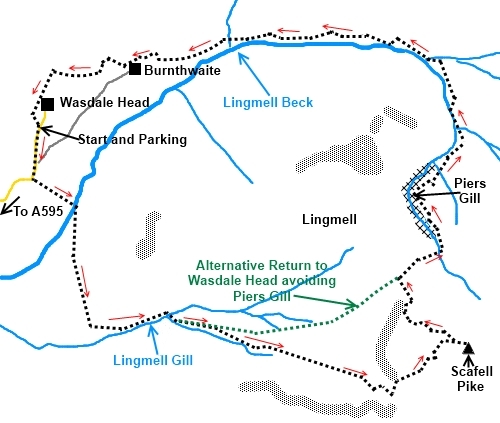
Introduction:
This
is a hard walk but this is one of those hills you just have to climb, it
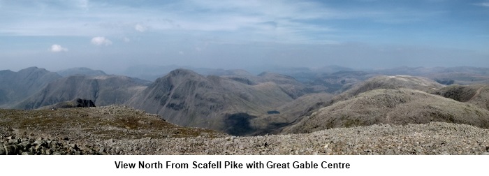
being the highest mountain in England at 978 metres (3209 feet). There are superb 360
º views from the top with the whole of Lakeland laid out before you.
If I had to pick one word to describe this
walk it would be “stone”. You ascend stony tracks (either
“manicured” or natural), the top is one huge pile of stones ideal for
ankle breaking! The descent is also stony. Possession of the equipment and
the knowledge to navigate with
map and compass are essential for safety in poor visibility on Scafell Pike
due to difficulty defining the path across the rocks. There are sheer drops!
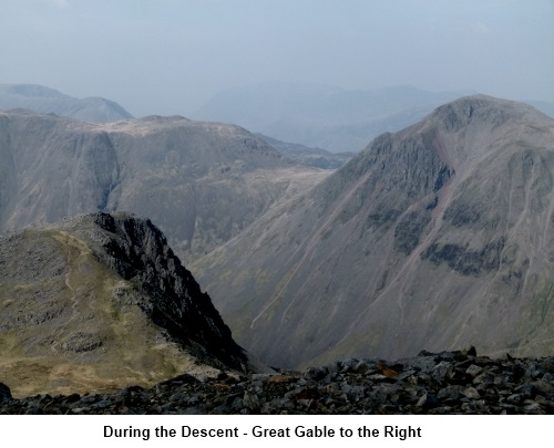
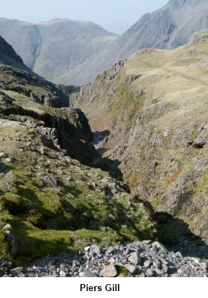
Cliffs tower above you as you climb. On the descent, I have chosen to view
and follow the dramatic Piers Gill which is a deep vertiginous cleft in the
rock. A word of warning here, the path alongside Piers Gill approaches very
close to its edge in places and there is one section of about 40 feet of
very steep rock down which you have to climb. If you have vertigo issues,
this part of the walk is probably not for you and after having a peek at the
south eastern end of Piers Gill, you might prefer to take the more direct
route back to Wasdale Head.
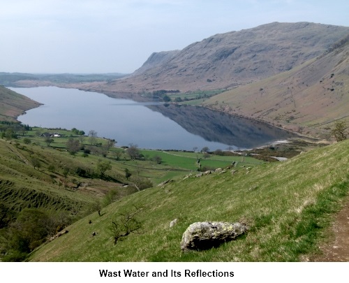
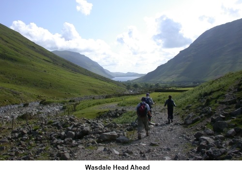
On a more positive note, the journey to
Wasdale Head itself is worth the
trip for spectacular views and if Wast Water is still, the reflections of
the screes are amazing.
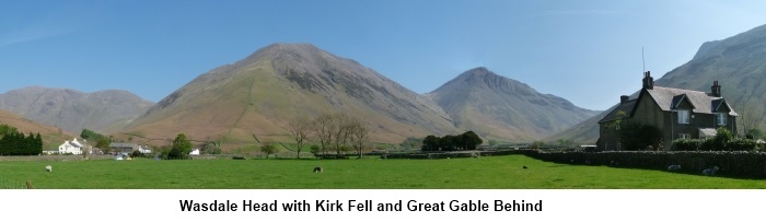
Start: The walk starts at Wasdale Head which is a
dead end valley for vehicles (NY 187086). To get there, turn north east on to one of the
various roads off the A595 between Ravenglass and Gosforth (or indeed from
Gosforth). The roads are well signposted. Keep going until the road ends
where there is plenty of parking at Wasdale Head although at peak times it
does fill..
Start the walk by walking back down the road
from Wasdale Head for no more than 300 yards and look out for a footpath
sign on the left “Scafell Massif via Hollow Stones” (NY 186083). Take
this path shortly going over a footbridge. The work starts here!
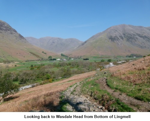
The footpath is well worn and easy to follow.
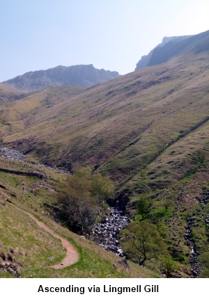
As the path rounds the lower slope of Lingmell where there are good views of
Wast Water, there is a faint path
to the left (NY 190074). Ignore this and continue on the obvious main path
which follows the course of Lingmell Gill. At an altitude of 963
feet (courtesy of my GPS) (NY 195075), the path crosses the Gill. There is
no bridge here so cross carefully. You will see the path at the other side
where it has been “manicured” with boulders to prevent erosion.
The path climbs ever steeper becoming shale
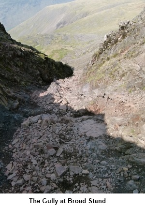
underfoot. Where the path forks, take the right fork. It passes beneath the
steep cliffs of Mickledore and leads to a gully up which you scramble (NY
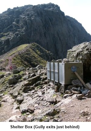
210069). It is a little loose underfoot but a fairly easy ascent. At the col,
turn left (north east) towards Scafell Pike almost immediately passing a
mountain rescue stretcher box. You will see Scafell Pike across towards the
right.
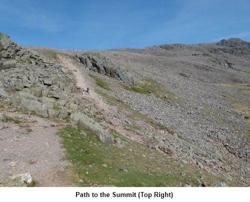
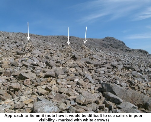
The
track itself is not easy to see across this very rocky hill but
it is well marked with cairns. If you are faced with poor visibility,
navigating across to the trig. point could be tricky as the cairns will not
be clear and should not be attempted without a compass. The trig point lies
at about 67º magnetic from near the stretcher box (unadjusted for mag.
variation) although the route of the path does “wiggle” about a little.
As you get in clear sight of the summit
itself, look out for another line of cairns indicating a route away to your
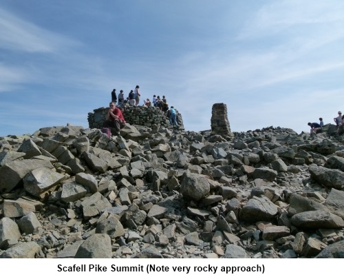
left (north west) which will be the return route from the top. The summit is
indicated by a stone built trig. point (NY 215072) and a large stone viewing
platform. There are also several crudely built semi-circular shelters dotted
about.
Enjoy
the views from the summit before following the route mentioned above. The
general direction of the route across the rocks is 302º (unadjusted)
initially for about half a mile from the trig point before changing briefly
to a north easterly direction but again it meanders to find the easiest
path. After that half mile, the path becomes more obvious.
Descend Scafell Pike until you come to a
crossroad of paths (NY 210077). A line of cairns indicates our route right
(north easterly) to Piers Gill. The left turn (south west) is the direct
route back to Wasdale Head should you either not wish to visit Piers Gill or
having seen some of it, you decide not to walk its length for the reasons
given earlier.
For Piers Gill, turn right at the
aforementioned crossroads. The main track soon heads off into the distance
towards Styhead Tarn but after less than a quarter of a mile take the
fainter track to the left (NY 214077). Piers Gill should now be obvious and
the path follows its right hand edge. The Gill performs a sharp right turn
half way along.
At the end of Piers Gill, continue to descend
following the path to the right of Lingmell Beck (as opposed to Lingmell Gill) by which you ascended.
Follow the Beck curving west back towards
Wasdale Head. In places it is a little boggy and a little indistinct but the
direction you want is obvious, just stick to the valley bottom. As the Beck
swings south west to follow the curve of Lingmell, continue westwards
towards the buildings of Wasdale Head which you should be able to see.
The Wasdale Head Hotel provides welcome
refreshment.
If you need to buy any hiking
equipment/clothing before your trip see the Hiking
Store
Before
venturing on to the Lake District fells, for your own safety, please check
the Fell
Top Conditions
All information on this
site is given in good faith and no liability is accepted in respect of any
damage, loss or injury which might result from acting on it.
|


.jpg)
.jpg)
.jpg)