|
Skiddaw
Walk
Starting point and OS Grid reference:

Ormathwaite
free car park (NY 281253)
|
Ordnance Survey Map
OL4
– The English Lakes, North Western Area.
Buy this map from
List
of OS Maps
Note: If you use OS Maps on-line, you can download this route via this
link.
| |
Distance: 6.9
miles
|
Date of Walk: 1
May 2013
| |
Ascent:
Descent:
See Walking Time Calculator
|
870m (2854)
872m (2862)
| |
Traffic
light rating:


(For explanation see My
Walks page)
| |


For advice on .gpx files see
My Walks page
|

Click
the PDF logo above to give a printable version of this walk without the
photos.
|
To
view route as a dynamic Ordnance Survey map click here.
Introduction:
A Skiddaw walk is a popular excursion
in the Lake District as for the thousands of walkers who stay in Keswick, as
it is almost the first mountain you see as you step out of the door. It
towers above the town. It is also popular because it is one of the few
mountains in England over 3,000 feet high, at 3054 ft. (931m) and therefore
on many mountaineers’ “must do” lists.
A consequence of its popularity is that you
are bound to have company on the way but they will be fellow walkers, so
decent folk!
A plus is that the routes are so well trodden
that it is almost impossible to get lost, even in poor visibility. I say
“almost” because the route I describe off the summit can be a little
tricky to spot if the cloud descends – a not infrequent occurrence over
3000 feet! More about this below. If in doubt, you can always come back the
same way but I prefer circular routes.
It is a hard walk, very steep ascent almost
from the word go and an equally steep descent which can be hard on the
knees. There is no scrambling however. The last section is a 1.8 mile walk
along the lane behind Applethwaite but do not let that put you off as the
views along here, across to the Derwent Fells, are truly fine.
The best places for a picnic are probably the
shelters close to the summit or on the descent as you get close to Carlside
Tarn.
There are various routes up Skiddaw but this
one starts at the Ormathwaite car park.
To get there, turn north east off the A591
just north of the roundabout which joins with the A66, to the north of
Keswick. There is a turn signposted to Ormathwaite and Underscar immediately
after the roundabout but you would have to be really on the ball to spot it
in time (and so would anyone behind you!). Better to spot this as you pass
then take the next turn, less than half a mile further on signposted for
Applethwaite. Follow this into the hamlet and turn right at the ‘T’
junction. Turn left at the junction bearing the road sign “Skiddaw via
public footpath”. This road is somewhat “potholey” but passable with
care by ordinary cars. Follow the road to its end, ignoring the first car
park by some trees. It culminates in a free, unsurfaced car park. The
convention seems to be to park at one side, at right angles to the approach.
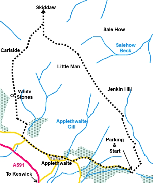
Start:
The path starts at the end of the car park (NY 281253), indicated by a fingerpost for
Public Bridleway, Skiddaw, Bassenthwaite and
Mosedale. You can see the wide clear path wending its way up the
hill. It begins fairly level and you pass a memorial to two shepherds,
Edward and Joseph Hawell.
%20Shepherds%20memorial%20and%20view%20back%20to%20St%20Johns%20in%20the%20Vale.jpg)
%20View%20showing%20clear%20ascent%20path.jpg)
%20View%20of%20Keswick%20and%20Derwentwater.jpg)
Very
soon, after going through a walkers’ gate, it splits and you want the
steeply climbing left hand path (NY 283256).
There is now a hard uphill walk for a while.
Just after it levels out slightly, come to a fork in the path. Take the
right hand path through a walkers’ gate which is signposted for Skiddaw
(NY 272275).
Follow the obvious path to the summit., the
path climbs steadily. There are a number of cairns. It then starts to
descend and, if you happen to get caught in low cloud (as I did), first
reaction might be that you have overshot the summit. However, you will not
have passed the trig. point and in fact the path then starts to rise again
to it.
When you actually arrive at the summit, there
is a rough low circular stone shelter, orientation table and the trig point
itself (NY 260291).
%20Skiddaw%20Summit.jpg)
Return from the summit, initially the same
way. The route down is difficult to spot amongst the shale, especially in
poor visibility. The OS map shows several tracks but I mention what I think
are the clearest two as follows.
Retrace your steps from the trig. point due
south for about 300 yards and at the sixth cairn (more
like a semi circular shelter) look out for the path on the right at NY
261288. More cairns mark the route down.
If you miss this, there is another which connects with it, leaving
the top at NY 260286. This is at the next cairn after a (poor) shelter
circle, just beyond the rise after the slight downhill from the summit.
Descend to the col, where there are good
views to Keswick and Derwent Water to the left and Bassentwaite Lake to the
right. Incidentally, worth noting as an occasional pub quiz answer,
Bassenthwaite Lake is the only “lake” in the Lake District. All the
others are “waters”, “meres”, or “tarns”!
%20Bassenthwaite%20Lake%20from%20Carlside%20tarn.jpg)
%20Derwentwater%20from%20Carlside%20Tarn.jpg)
At Carlside Tarn, the path forks (NY 256282).
Go left gently climbing over Carlside (hill).
The path is easy to follow. At some white
rocks, fork left (NY 254272).
The path eventually becomes a grassy path and
joins another. Go right here and follow it down to the road. Turn left at
the road.
%20Looking%20Down%20Towards%20Applethwaite.jpg)
%20Skiddaw.jpg)
Stay on the road passing the white painted
wayside chapel and go left at the “Skiddaw via public footpath” road
sign you saw on the drive up, to get back to the car.
If you need to buy any
hiking equipment/clothing before your trip see the Hiking
Store
Before
venturing on to the Lake District fells, for your own safety, please check
the Fell
Top Conditions
All information on this
site is given in good faith and no liability is accepted in respect of any
damage, loss or injury which might result from acting on it.
|


.jpg)
.jpg)
.jpg)