|
Striding
Edge and Helvellyn
Starting point and OS Grid reference:

Pay and Display car park at Glenridding (NY 386170)
|
Ordnance Survey Map
OL5
The English Lakes - North-eastern area.
Buy this map from
List
of OS Maps
Note: If you use OS Maps on-line, you can download this route via this
link.
| |
Distance: 7.4 miles
|
Date of Walk: 31 July 2009
| |
Ascent:
Descent:
See Walking Time Calculator
|
969m (2850ft)
968m (2847ft)
| |
Traffic
light rating: 
(For explanation see My
Walks page)
| |


For advice on .gpx files see
My Walks page
|

Click
the PDF logo above to give a printable version of this walk without the
photos.
|
To
view route as a dynamic Ordnance Survey map click here.
Introduction:
This is
probably the most famous walk in the Lake District and the “must do” if
you are visiting the area. It is a horseshoe walk providing dramatic views
and a real feeling of drama and exposure. It has the potential to be
dangerous but only if care is not taken or if it is attempted in the wrong
conditions. I have done it many times, including in snow and ice but I was
properly equipped with crampons and ice axe. Do not undertake this walk if
it is very windy or in snowy and icy conditions unless you know what you are
doing and have the equipment. Above all, if it is snowy, beware of cornices
of snow which may have blown out from ridges. From above, they look solid.
Do not go close to snowy edges. There has been more than one death caused by
people falling through these cornices.
The walk is
much easier and safer if done in the order described as a rocky scramble is
climbed rather than descended.
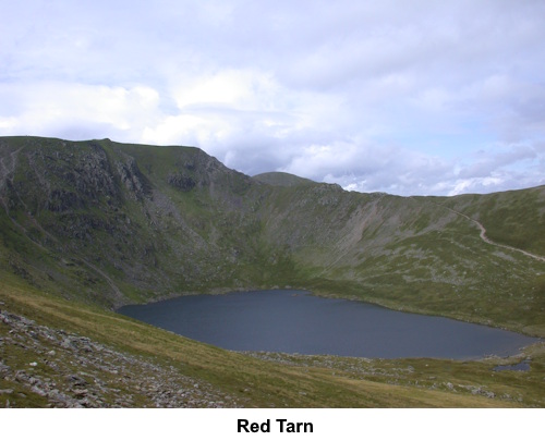
In good
conditions it is a fabulous walk with great views of Red Tarn below and a
real feeling of achievement at the end.
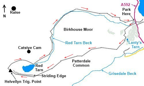
Start: The walk
starts from the pay and display car park in Glenridding (NY 386170). Turn right out of
the car park, on
to the main road and turn right. Go over the beck then turn right along the
road in front of the shops where the bridleway sign indicates to Mires Beck
and Helvellyn.
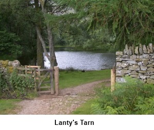
The road
becomes a footpath. It is possible to take a more direct route avoiding
Lanty’s Tarn but it is such a pretty spot it is a shame to miss it. Follow
the footpath until you see a sign pointing left to Lanty’s Tarn. Follow
the signs and after climbing some stone steps, you will arrive there (NY 383163).
From the
northern end of Lanty’s Tarn, take the path in a south-westerly direction.
After passing through Brownend Plantation, turn right at a crossroad
of footpaths (NY 380159). The obvious path now starts to climb ever steeper and all you
really need to do is keep climbing.
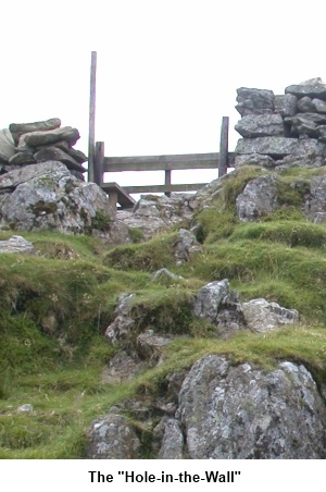
After about
1.3 miles, you arrive at the Hole-in-the-Wall (NY 360155), literally that where a wooden
stile takes you on
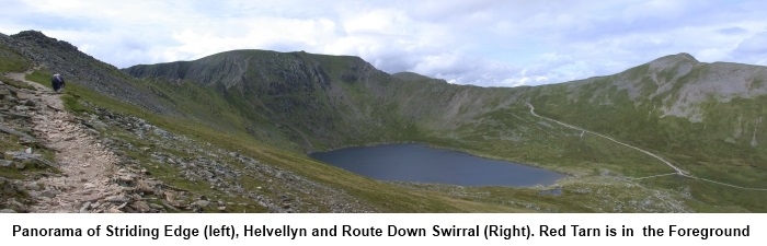
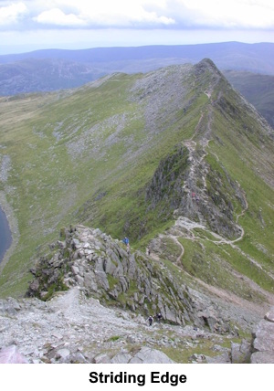
to Bleaberry Crag and Striding Edge. From the Hole-in-the-Wall, the line of
the entire ridge stretches out before you and you can see the entire
horseshoe circling Red Tarn, across the top of Helvellyn and down Swirral
Edge at the other side.
 Walk along
the ridge taking whichever route you are comfortable with. There are
sections where you can scramble along the rocky top of the ridge or take a
more conventional footpath. Walk along
the ridge taking whichever route you are comfortable with. There are
sections where you can scramble along the rocky top of the ridge or take a
more conventional footpath.
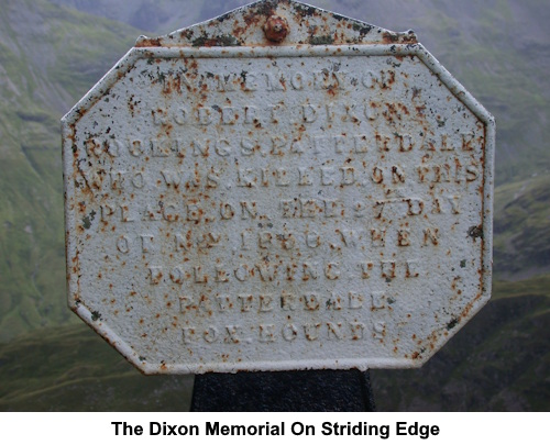
Keep a look
out for the Dixon Memorial on the left which is easy to miss and
commemorates Robert Dixon who fell to his death following the Patterdale
hounds.
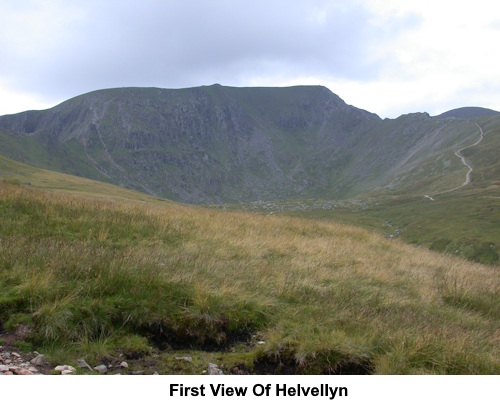
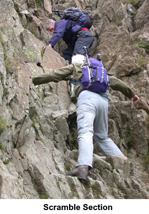
Eventually,
you will see a very steep rocky ascent ahead of you to the summit but just
before this is possibly the most difficult part known colloquially as “The
Bad Step”. This is basically a descent down a 15/20 feet rocky
“chimney” which involves an actual climb down the rocks. There are
plenty of hand and foot holds and it is not difficult, just take care and do
not rush. All the routes converge at this spot and at busy times you will
probably find yourself having to queue.
Once down The
Bad Step, you then have a daunting but straightforward scramble up to the
summit passing the Gough Memorial.
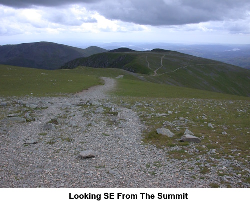
On reaching
the top of the scramble, the route heads north-west to the cross shaped (to
give protection from winds from any direction) shelter. There are stone
seats which provide a good lunch stop. The
trig. point is a little distance further on (NY 342152).
Follow the
ridge round in a clockwise direction and not too far beyond the trig. point
the path descends Swiral Edge. Once again take care on this descent.
The path
descends to the north-east corner of Red Tarn (NY 350154) although if you are in peak
bagging mode, you can make a short diversion by branching off left about
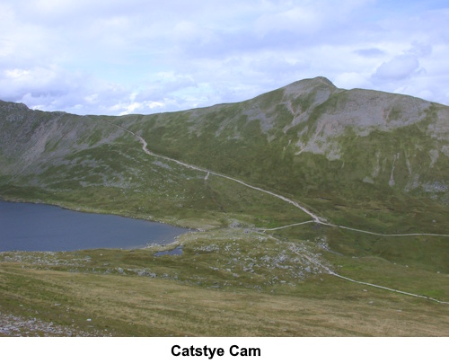
half way down and climbing to the top of Catsty Cam (NY 348159) (properly Catstye Cam) and back. From Red
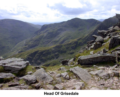
Tarn, the route heads in a north-easterly direction until it reaches Red
Tarn Beck. It then follows this beck until, after crossing the beck via a
footbridge (NY 364173), it
reaches the old mine buildings and Glenridding Youth Hostel. Follow the
track/road (Greenside Road) to Glenridding turning right at the “T”
junction then next left to pass in front of the Travellers Rest pub (still
Greenside Road). Continue back to the car park.
If
you need to buy any hiking equipment/clothing before your trip see the Hiking
Store
Before
venturing on to the Lake District fells, for your own safety, please check
the Fell
Top Conditions
All information on this
site is given in good faith and no liability is accepted in respect of any
damage, loss or injury which might result from acting on it.
|


.jpg)
.jpg)
.jpg)