
|
|
|
To view route as a dynamic Ordnance Survey map click here. Introduction: I guess that the majority of people who walk from
Wycoller head South-East along the beck side to see the ancient bridges and
the ruin of Wycoller Hall before perhaps climbing Boulsworth Hill and/or Lad
Law. Indeed I have done this myself (See my Wycoller to Boulsworth Hill and
Lad Law walk). However
it can be interesting to explore the unconventional direction as does this
walk to Knarrs Hill and to Black Lane Ends where the pub of the same name
offers a tempting interlude! Wycoller
Hall and bridges are mostly covered in my other walk but I will just mention
the packhorse bridge you come to not far after the start which is quite
famous. It has two uneven arches and is believed to date from somewhere
between the 13th and 15th Centuries. Knarrs
Hill does not have any particular claim to fame other than having a trig.
point and being on the Pennine Bridleway and Pendle Way. However there is a
great view from there. It is thought the name Knarrs may come from a Norse
merchant and cargo ship, a knarr,
though we are a long way from the sea here. Black
Lane Ends, as the name suggests, is at a junction of roads and footpaths and
a pub of the same name (previously known as the Hare and Hounds) awaits. I
can vouch for the quality of its food and beer! One interesting snippet I
came across was that on 4 April 1862, one Walker Moore murdered his
estranged wife Betty in the pub, when she was on her knees tending to the
fireplace, because she would not return to him. He openly admitted his
crime. He was tried at Lancaster on 13 August 1832. He was due to be
executed on 30 August but committed suicide on the same morning by going to
the toilets and climbing into the cistern which supplied them. As
you descend from the car park at the start, you will see a number of
vertical stones along the edge of the field. These are Vaccary Stones. There
are various theories as to their age from Bronze age onwards but Medieval
seems to have the most ‘votes’! ‘Vaccary’ comes from the same term
meaning a place where cattle are kept. You might remember similar
‘Vache’/’Vaca’ from French/Spanish lessons. The
return journey follows High Laith and Wycoller Becks. The
walk is easy going but there are a lot of footpaths and footpath junctions
in the area which can be confusing. The
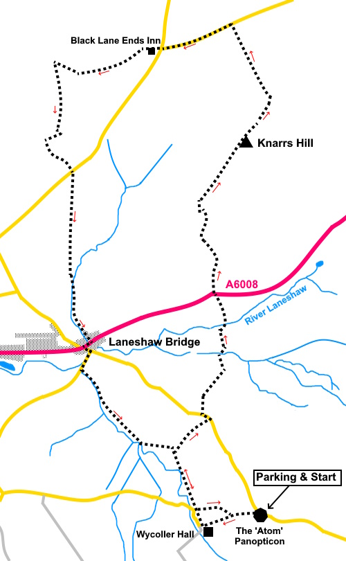
walk starts from the ‘Atom’ car park at Wycoller. The
Panopticon, 'Atom' is an art installation completed in 2006. It is made of
ferro-cement with a surface coating of metal-based paint and shows off a
spectacular viewpoint. To
get there, take the road off the A6068 at Laneshaw Bridge, opposite the
Emmott Arms, between Colne and Cowling, where there is a brown tourist sign
for “Wycoller Country Park”. Stay on this road and the car park is on
the right after just under a mile. Start: Take the descending footpath which leaves the car park immediately opposite the entrance. This leads quite steeply downhill arriving at a packhorse bridge.
Do
not cross the bridge but turn right following the right hand side of the
beck. After
a short distance, the track divides. Fork right. At
a broad grassy track, turn left following a blue bridleway arrow
and bearing left as you enter a field. You arrive at a two way
fingerpost but turn left in the direction with no fingerpost! On
joining a broad track, turn right and follow it until you reach a metal
kissing gate and once through it, bear right. As you get further across the
field, you should spot a walkers’ gate after crossing a shallow valley. Bear
right after the walkers’ gate and follow the path to the road.
Turn
left at the road for only a few yards, then right to follow a public
footpath fingerpost. You are now on a tarmac farm drive. As
you get to the edge of the enclosure of the farm (Robert Laithe on the OS
map), turn left at the corner of the fence following a public bridleway
marker, then right through a gate at the next corner. The
path is well trodden and takes you to the A6068 and the route continues
immediately across the road, to the right of the white building. Stay
on this main track, passing Monkroyd Barn. When
the track splits, turn right (i.e. avoiding the left to Earl Hall Farm). When
the track bends sharp right heading to Knarrs Farm (SD 933419), turn left
through the right hand of two farm gates, then immediately right to follow
the farm wall. Look
out for a gate on the right and turn through it, following a blue bridleway
arrow. You now need to bear slowly left away from the trees, to the far left
hand corner of the field.
You
can see a small ‘hump’ of a hill which is the summit of Knarrs hill and
your aiming point.
At
the far left corner of the field go through a gate, then over a gated stone
stile. Follow the wall on the right. Just
beyond a bench, cross a stone stile at which point you are upon the trig.
point. Turn left to follow the wall, and join a broad track from the farm.
Turn left along it.
You
now follow this clear drive for just over half a mile to the road. Turn left
along the road to the Black Lane Ends pub. The
walk continues up the right hand side of the pub, as indicated by a public
footpath fingerpost.
Go
through a farm gate into a large field and head uphill at an angle of about
40° to the bottom boundary. Here you will find a gated slit stile marked
with a yellow footpath arrow. Through this, follow the obvious path.
You
join the broad track to a farm. Turn left (SD 920431). As
you get to the next farm, (Jerusalem Farm) turn sharply right just after the
first barn on the right, through a walkers’ gate. The path runs up the
side of the barn. Cross
a stone step stile and continue following the wall on the left. As
you come in sight of another barn, look out for a broad track on the left
which goes down to the farm. Follow this for a few yards and take a
walkers’ gate on the left marked with a yellow arrow. Circle
to the left of a large round tank to avoid the mud and when you get to the
concrete drive to the farm, turn left along it. At
the road, turn left for fifty yards or so then turn right through a slit
stile and follow the wall on the left. When
you get to the farm (Shay Gate Farm on the OS Map), continue through the
farmyard and keep straight ahead, through a five bar gate. As
the track turns right, carry straight on through another farm gate. You
now follow the course of a stream on the right all the way to the main road
(A6068) at Laneshaw Bridge. You cross a footbridge which seems to have
replaced the stepping stones marked on the OS map, then right through a
gated step stile, after which turn left.
Turn
right at the A6068 then left along School Lane. Cross
the river bridge then turn right along Carriers Row. There are one or two
properties then a long terrace of cottages built with Yorkshire Stone. At
the end of this row, turn left along a broad track indicated by a public
footpath fingerpost.
After
going through a walkers' gate, turn right. Follow
this path until you reach a group of stone houses and join a lane. Turn left
following the sign for Pepper Hill Barn. Look
out for a track on the left which you may remember from the outward journey
Climb to another track and turn right. After a few yards, go left through a
walkers’ gate. The
footpath follows a clockwise arc which may not be clear in this fairly rough
field. Aim to reach the right hand boundary of the upright field boundary
stones you saw on the outward journey, at the point where the slope
increases significantly. Here cross a stile then turn left to return to the
car park. If you need to buy any hiking equipment/clothing before your trip see the Hiking Store All information on this site is given in good faith and no liability is accepted in respect of any damage, loss or injury which might result from acting on it.
| | |||||||||||||||||

.jpg)
.jpg)
.jpg)
%20descending%20the%20path%20to%20Wycoller.jpg)
%20Vaccary%20Walls.jpg)
%20Packhorse%20Bridge%20at%20Wycoller.jpg)
%20Autumn%20colours%20en%20route.jpg)
%20View%20east%20to%20Earl%20Crag%20and%20Cowling%20Pinacle.jpg)
%20View%20NE%20from%20Knarrs%20Hill.jpg)
%20Trig%20point%20on%20Knarrs%20Hill.jpg)
%20Looking%20back%20to%20Black%20Lane%20Ends.jpg)
%20Autumn%20colours%20at%20Kelbrook%20Woods.jpg)
%20Waterfall%20on%20High%20Laith%20Beck.jpg)
%20Autumn%20Colours%20by%20Wycoller%20Beck.jpg)