|
Lanzarote
Walk - Famara
|
Starting
point:

Urbanization
Famara – parking on a dirt road to the rear of the urbanization or on the
beach road.
|
Map
I
have found this to be the best map for both walking routes and driving, from
Discovery Walking Guides Ltd
Lanzarote
Tour and Trail Map 1:40,000 scale

| |
Distance:
4.65
miles
| |
Traffic light rating:

(For explanation see My
Walks page)
More great Lanzarote
Walks
|

Click
the PDF logo above to give a printable version of this walk without the
photos.
|
Introduction: Caleta
de Famara, Urbanization Famara
and Playa de Famara are the components of a big sweeping bay to the north of
Lanzarote. Caleta de Famara is the traditional old fishing village. The
Urbanization is a curious rectangular grid of streets set apart from the
village consisting of curious semi circular houses.
Playa de Famara is
the spectacular massive beach of superb golden sand stretching round the
bay. The sea here can be very rough and if you are lucky, you can watch the
antics of the surfers and kite surfers amongst the breakers.
At the northern
end of the bay are the massive Risco de Famara sea cliffs rising to over 400
metres. There are also views out to Isla Graciosa.
The walk is an
easy 4.65 miles along an elevated track before dropping down to another
track at the rear of the beach. In fact if you want, you can walk much of
the way back along the beach. You will see from the sketch map that the
outward leg reaches a point where I stopped and retraced my steps. This was
because ahead there seemed to be evidence of rock falls and landslips and
the way looked none too stable.
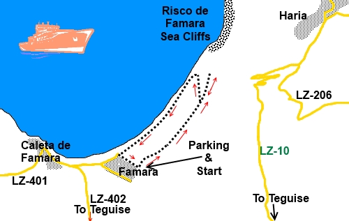
The walk starts
from a dirt road to the rear of the Urbanization. To get there, assuming you
arrive via the LZ-402 from near Teguise, turn right at the ‘T’ junction
just behind the beach along a fairly rough metalled road, probably dodging
round the sand dunes which usually encroach. Take the first right up the
side of the Urbanisation then left at its end. There is a wide dirt road
where you can park. Alternatively, there is plenty of parking along the road
at the back of the beach.
Start:
From
the dirt road behind the urbanization, with the sea to the left, simply
follow the dirt track straight ahead.
%20Start%20of%20the%20walk.jpg)
Ignore
a descending track after about 1/3 mile and keep
straight on. After about half a mile from the start, you pass a well tended
villa above and to the right, with terraced agriculture.
%20View%20back%20towards%20Urbanization%20de%20Famara.jpg)
%20Dramatic%20Risco%20de%20Famara%20cliffs.jpg)
%20Small%20white%20house.jpg)
After
almost another mile pass a curious small white house. There is a large spoil
heap at the front and it looks as though some sort of tunnel has been dug
into the hillside.
From
this house, a track descends to the left and ultimately, this is your return
path.
How
much further you want to continue first, is up to you. Beyond the house, the
quality of the track starts to deteriorate. There are good views of the
cliffs and out to Isla Graciosa.
%20View%20to%20Isla%20Graciosa.jpg)
%20The%20Sweeping%20bay%20of%20Caleta%20de%20Famara.jpg)
Return to the white house and descend to the
lower track behind the beach and turn left to return to the Urbanization
Famara.
%20The%20beach%20at%20Caleta%20de%20Famara.jpg)
%20Dunes%20at%20Famara.jpg)
%20Kite%20Surfing.jpg)
If you need to buy any
hiking equipment/clothing before your trip see the Hiking
Store
All information on this
site is given in good faith and no liability is accepted in respect of any
damage, loss or injury which might result from acting on it.
|


.jpg)
.jpg)
.jpg)