|
Lanzarote
Walk - Hidden Garden of Casita
|
Starting
point:
Playa
Quemada – Large rough parking area in the village centre.
|
Map
I
have found this to be the best map for both walking routes and driving, from
Discovery Walking Guides Ltd
Lanzarote
Tour and Trail Map 1:40,000 scale

| |
Distance:
4.4
miles (2.2 miles each way)
| |
Traffic light rating:

(For explanation see My
Walks page)
More great Lanzarote
Walks
|

Click
the PDF logo above to give a printable version of this walk without the
photos.
|
Introduction: This walk
is not one you are likely to find in the main stream walking books. I
have called it the Hidden Garden of Casita simply because it sits at the
foot of the Barranco of that name. You are unlikely to resist a “Wow”
when you see it!
It
is an easy, short walk from Playa Quemada and is a linear “there and
back” walk. If you wanted a longer day, you could combine it with my other
walk from Playa Quemada to Puerto del
Carmen.
The
walk gives good views of the mountains inland from Puerto del Carmen before
passing Playa del Pozo and arriving at this remarkable hidden garden at the
foot of the Barranco de la Casitas, virtually on the beach.
It is remarkable
“oasis” of garden and art in a pretty barren landscape. Alongside the
planting is something of a grotto under the overhang of the cliff, where
people leave “stuff” ranging from toys to ornaments and there were a
couple of visitors books.
It
seems to be common practice to write names/messages on pebbles and indeed a
felt tip pen was provided, if somewhat worn flat, so if you want to do this
I suggest you take your own.
It
is a testament to all visitors that the garden and grotto are respected, so
please continue the tradition.
At
the time I did the walk, why the garden was there and who created it was a
mystery. However, a year later, someone who had followed my directions
bumped into the creator, Natalia, a women who lives in Arrecife and, with
the help her son Carlos, who comes from Tenerife in the holidays, has
maintained the garden for about 30 years. They are rightly proud of their
work. They have to carry water to the place from time to time to keep the
plants green! It is to be hoped that in the fullness of time, the baton can
be passed to someone else to keep the garden going.
I
revisited the walk in 2022 and noticed the plaque, which I missed the first
time. It is in Spanish but a translation is:
The Secret Garden has been made by my parents, Juan Maria and Natalia (those with the Yellow Toyota).
They started in the late 80's to entertain the days when the sea was bad for fishing.
During all these years we have been expanding it by maintaining and repairing it.
The name The Secret Garden was written in stones by a tourist who passed by here (that's why it's in English).
We started decorating it with buoys brought by the tide, but the people who visit it got used to leaving souvenirs.
Just outside the garden is the grave of Kevin, the guard dog who barked at visitors for over ten years
The
beach at the Barranco de la Casita is a quiet spot and you are not likely to
see many (any) people. Unusually, there is some shade to be had, from the
cliffs.
You
barely need a route description – just follow the coast – but there
several paths and I have described the most straightforward which minimises
the ups and downs.
The
walk starts from Playa Quemada although there is a trail down the Barranco
de la Casita via Femes if you wanted a more substantial walk.
As
you walk along the cliffs, out to sea is the clearly visible fish farm
which, produces some 2000 tonnes of seabass (dorada) and seabream (lubina)
each year.
To get to Playa Quemada,
turn south off the LZ 2 (signposted). The walk starts from the large earth
parking area on the right just as you turn into the village (where the
dustbins are).
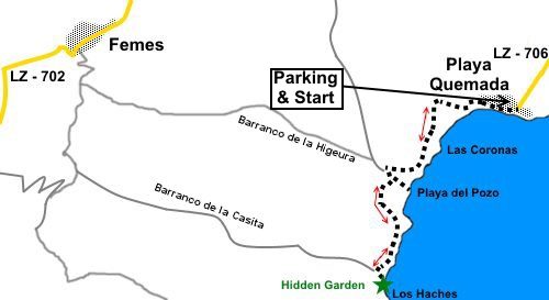
Start: From
the parking, facing the sea, turn right along the tarmac road. When it bends
right, stay parallel with the coast until you can branch off right up a
rough path, to what is almost a separate part of the village. At another
tarmac road (Calle Playa de la Arena), turn left along it.
At
its end, turn left by a notice board to climb the dusty path.
%20Playa%20Quemada.jpg)
Arrive
at a sign proclaiming the Monumento Natural Los Ajaches. Follow the path to
the right of this.
%20Fish%20Farm.jpg)
The
path descends gently to the head of a little valley. Follow it up the other
side. It soon forks. Take the right fork which avoids a steeper descent to
the beach. (Playa de la Arena) and subsequent climb up.
%20View%20to%20Mountains%20and%20Playa%20del%20Carmen.jpg)
Pass
and ignore a path on the left which is the climb from the beach.
Pass
a trail coming in from the right marked by a flat steel post.
You
reach the wide Barranco de la Higuera, which has a broad track running along
the bottom. At the other side of the barranco, you should see a broad
climbing path, to the right of a derelict building, which is your onward
route. However you might like to venture left along the valley bottom track
first, to see the Playa del Pozo (Well’s Beach), a black beach where there
is another ruined building, a shelter with seat (though without any roof
when I visited) and an old well.
%20approaching%20Playa%20del%20Pozo.jpg)
%20Well%20at%20Playa%20Del%20Pozo.jpg)
%20Telephoto%20shot%20of%20fish%20farm.jpg)
Return
to the junction and climb the broad path to the right of the derelict
building. Just beyond the building is a junction marked with a fingerpost
turn left here. It is worth mentioning that the direction of some of the
fingers looked questionable!
Quickly
arrive at another fingerpost and again keep left.
%20Approaching%20beach%20at%20Barranco%20de%20la%20Casitas.jpg)
The
next barranco is your target, the Barranco de la Casita. The path zig-zags
down the side. I recommend you follow the zig-zags rather than trying a more
direct approach. The path turns inland for a hundred yards or so before
arriving at the valley bottom. Turn left along the track at the bottom to
the beach and the garden.
%20Artistic%20rope.jpg)
%20Garden.jpg)
%20Garden%20-%202.jpg)
%20Art%20of%20the%20machine.jpg)
%20The%20Grotto.jpg)
%20Along%20the%20beach%20at%20Barranco%20de%20la%20Casitas.jpg)
The
return to Playa Quemada is a case of retracing your steps.
If you need to buy any
hiking equipment/clothing before your trip see the Hiking
Store
All information on this
site is given in good faith and no liability is accepted in respect of any
damage, loss or injury which might result from acting on it.
|


.jpg)
.jpg)
.jpg)