
|
|
|
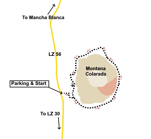
Introduction: This is probably the easiest walk you could do on Lanzarote. It circles the cone of Montaña Colorada on a very well ‘manicured’, level, wide track. You could easily walk it without boots, though I would caution against sandals as you will be forever fishing out the gravel! Montaña Colorada is a distinct volcanic cone and was one of the last to erupt during the Timanfaya eruption (1730 to 1736). It has a distinct red section on its south-eastern side which contrasts remarkably with the green vegetation starting to get a foothold. Montaña Colorada means ‘red’ or ‘coloured’ mountain in Spanish. There are some large examples of some of the lava ‘bombs’ which rained down during the eruption. The circuit of this volcano provides some great panoramic views of central Lanzarote and its distinct volcanoes and settlements. Navigation is simply not an issue. Just follow the clear track but note that wandering off the track is strictly forbidden and despite the appearance of a path up the cone, this is private and you are not allowed up there. The authorities are trying to preserve the purity of the landscape and you could be punished if you are caught transgressing! There are a number of very interesting information boards around the route. You may note that this volcano is very close to Montaña Cuervo and indeed there is a path linking the two, should you wish to visit both. Montaña Colorada is accessed from a parking area on the east side of the LZ 56, which runs due north to Mancha Blanca from the LZ-30. Start: From the parking area, just follow the signs. There is an arrow indicating an anti-clockwise way around the volcano but you can go either way. That’s it!
If you need to buy any hiking equipment/clothing before your trip see the Hiking Store All information on this site is given in good faith and no liability is accepted in respect of any damage, loss or injury which might result from acting on it.
| | |||||||||||||

.jpg)
.jpg)
.jpg)
%20Caldera%20Santa%20Catalina.jpg)
%20The%20approach%20to%20Montana%20Colarada.jpg)
%20Montana%20Negra.jpg)
%20Montana%20Cuervo.jpg)
%20View%20of%20the%20central%20area%20of%20Lanzarote.jpg)
%20start%20of%20the%20red%20section%20of%20the%20cone.jpg)
%20One%20of%20the%20volcanic%20bombs.jpg)
%20The%20extent%20of%20the%20red%20area%20of%20the%20cone.jpg)
%20Montana%20Tamia.jpg)
%20Onward.jpg)
%20Montana%20Orliz.jpg)
%20Vinagrera.jpg)
%20Panorama.jpg)