
|
|
|
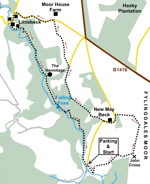
To view route as a dynamic Ordnance Survey map click here. Introduction: This walk to Falling Foss waterfall is an easy route with just a slight uphill segment at the start. This has the advantage of providing for some lovely views inland to the North York Moors and to the coast, from Fylingdales Moor. Much of the walk is through deciduous woodland and so is possibly best appreciated in the autumn but at any time it will be a peaceful and pleasant walk. Falling Foss is an impressive thirty foot waterfall in a pretty setting, along May Beck, in the Sneaton Forest. Next to it is Midge Hall, a former keeper’s cottage, which now operates as the Falling Foss Tea Garden. The word “Foss” in this context probably comes from old Norse and means waterfall. On the way and close to the waterfall is The Hermitage. This is a room with a stone shelf, carved out of a single boulder by a George Chubb in 1790. It is believed it is a folly commissioned by a local schoolmaster, to help out Chubb who was an out of work seaman. His initials are over the door. Littlebeck is a pretty hamlet and the start of Littlebeck Woods. The walk starts from a free car park at May Beck, where there is a handy bench for boot changing. To get there, turn west off the A171, just south of Robin Hood’s Bay, on to the B1416, signed for “Sneaton 4 miles” and “Ruswarp 5 miles”. After 1.7 miles, turn left following the sign for May Beck 1½ miles. Start: Exit the car park (NZ 893025) along the road on which you arrived. After about a hundred yards, turn right to follow the arrow on an old metal footpath sign. Depending on the time of year, you might find this section a little obscured by bracken. Climb the bank and cross a stile at the top. Bear slightly left and follow the course of the dilapidated wall. The worn grass makes the path fairly obvious. Pass to the right of a ruined cottage. Looking back, there are views to the North York Moors. Follow the path past the plantation, joining a broader track where you turn right to continue following the edge of the plantation. As you draw level with the end of the trees, go through a kissing gate. Here are the remains of John Cross, sadly now little more than a stump (NZ 901027). Ahead is a four way fingerpost and the left finger indicates your direction. However, in practice, people have walked alongside the wall and the path created here is clearer than that in line with the fingerpost. There are good views here, to the sea and inland.
Follow the wall until you reach a boundary stone with “CX3” and a three way fingerpost. Turn left through a walkers’ gate to follow the sign for “Coast to Coast” and “Littlebeck” (NZ 902032).
Follow the Coast to Coast signs until you reach the tarmac road. Turn left following “Coast to Coast” and “Littlebeck 2½ miles”.
Continue on the road round the corner, past New May Beck farm. As the road turns sharply left, look out for the old metal footpath sign on the right and cross the stile (NZ 896033). Follow the path down into a little valley where you cross the stream via a footbridge. The path is roughly straight ahead over the footbridge, up the banking. Turn left at a two way fingerpost and go through a walkers’ gate. The path follows the right hand edge of the trees, arriving at a steep stone step stile, more like a ladder! Cross this and follow the path through more trees. The path exits the trees over a stile. Turn left following a footpath fingerpost, along the left hand boundary of the field. At a gateway, walk down the fenced track, then the left hand field boundary to join the tarmac lane by the farm and turn right (NZ 889040). Follow the lane for about two hundred and fifty yards. Just after passing a stone cottage, turn left to follow an old metal bridleway sign (NZ 890042). The path immediately forks. Take the right fork, to the right of an “Access Land” marker post. When the path divides again, go left following the blue bridleway arrow. On meeting a broad track, go straight across it but ignore the signed public footpath going off to the right. There are views here across to Sleights. On reaching the road opposite Moor House Farm, turn left, down the steep lane (NZ 887040). At the junction, turn left again, for Littlebeck, passing a car park and village hall. There is a bench here with views which makes a good lunch stop.
As you come into the hamlet, just as the road bends right, take the footpath off to the left indicated by the fingerpost for “Coast to Coast” and “Falling Foss”. There is also a bench here (NZ 880049). At NZ 882048 there is what looks like a small cave. In fact this is the remains of the Littlebeck Alum works, which operated from about 1690 until 1809. Alum was extracted from the shale and used mainly in the dyeing industry as a fixing agent for the dyes.
The forest area here is looked after by Yorkshire Wildlife Trust. You leave their area at NZ884044, through a stone gateway. Follow the obvious path and, after climbing some steps, arrive at The Hermitage, bearing the date 1790 (NZ 886041).
Follow the path beyond The Hemitage. When it divides, turn right following the Coast to Coast path, indicated by a yellow arrow. At a three way fingerpost, turn right for “Falling Foss”. Take car along this section because there are some steep drops. You get to Falling Foss waterfall at NZ 888035.
Continue past the tea garden and over the footbridge, climb a short rise, to a three way fingerpost. Turn left to follow the sign for “May Beck Avoiding Ford Crossing”.
Once over the stone bridge, turn right following the Coast to Coast marker post. Follow the obvious path back to the car park. If you need to buy any hiking equipment/clothing before your trip see the Hiking Store All information on this site is given in good faith and no liability is accepted in respect of any damage, loss or injury which might result from acting on it.
|
| |||||||||||||||

.jpg)
.jpg)
.jpg)
%20Remains%20of%20John%20Cross.jpg)
%20View%20to%20the%20coast.jpg)
%20Panoramic%20view%20to%20NY%20Moors.jpg)
%20Boundary%20stone.jpg)
%20view%20from%20boundary%20stone.jpg)
%20view%20to%20Sleights.jpg)
%20Approach%20to%20Littlebeck.jpg)
%20Remains%20of%20Littlebeck%20alum%20works.jpg)
%20The%20Hermitage.jpg)
%20Falling%20Foss.jpg)
%20View%20upstream%20near%20Falling%20Foss.jpg)