|
Walk
From Kilburn
|
Starting
point and OS Grid reference:

Kilburn
White Horse free car park (SE 514812)
|
Ordnance
Survey Map
OL
26 – North york Moors – Western Area.
Buy this map from
List
of OS Maps
Note: If you use OS Maps on-line, you can download this route via this
link.
| |
Distance: 11.2
miles (or 9 miles – see text)
| |
Traffic light rating:

 or
or
(see text)
(For explanation see My
Walks page)
| |


For advice on .gpx files see
My
Walks page
|

Click
the PDF logo above to give a printable version of this walk without the
photos.
|
Introduction: This walk from Kilburn (or
more correctly from the Kilburn White Horse car park) can also be treated as
a walk from Boltby as it is a circular walk. It can also be done from the
North York Moors Visitors Centre at the top of Sutton Bank but this is a pay
and display car park whereas the White Horse car park is free!
It is a walk packed with interesting sights:
Gormire Lake – a lovely, spring fed,
natural lake surrounded by Garbutt Forest, and the only natural lake in the
national Park;
Boltby – a very attractive tranquil
village with a pretty church;
Impressive cliffs - Boltby Scar,
Whitestone Cliff and Roulston Scar;
North York Moors Visitors’ Centre
(toilets here);
Fabulous views;
Yorkshire Gliding Club - where you are
very likely to see gliders landing and taking off;
The famous White Horse of Kilburn -
created in 1857 by one Thomas Taylor of Kilburn who, having seen similarly
created figures in the South, wanted a notable creation for his village. The
White Horse is clearly visible for miles, indeed, that is the point, but as
you pass close to its top, it is so large and drops away so steeply, you
cannot get much of an impression of its shape. What is remarkable is that it
has survived so long without the limestone chippings slipping down the hill,
a feat which owes its success to a number of strategically placed
boards/pegs. Please do not attempt to walk on it at the steepness would make
this dangerous, not to mention the damage.
To
view route as a dynamic Ordnance Survey
map click here.
The route as described in full is 11.2 miles
but it can be shortened to 9 miles if required. See #
below. The going is mostly easy but
there is a section of steep climb to the top of the escarpment whether the
longer or shorter route is selected.
The easiest way to find the White Horse car
park is to turn south off the A170 where a brown tourist sign indicates
“Yorkshire Gliding Club” and “White Horse” at
SE 523829 and follow the road for 1.3 miles. The turn off the A170 is
half a mile east of the top of Sutton Bank, or just beyond the Hambleton Inn
if coming from the east.
Start: From the White Horse car park
(SE 514812), turn right and walk down the road for half a mile. Just after
passing a rough car parking area on the right, turn right, along a broad
very obvious bridleway (SE 515806).
When the broad track turns left to a farm,
keep straight ahead on the narrow footpath. Follow this until you come out
of the trees, then join a broad forest track and turn left. When this forks,
go left.
Stay on this track ignoring any turns off
until you come to a bridleway going off to the right with a fingerpost for
“Bridleway”, “Hood Grange” and “A170”. Take this. It descends to
a large field which you cross to Hood Grange which is clearly visible once
you reach the field.
At Hood Grange (SE 504823), turn left through
a gate and walk along the left hand bank of the beck. You zig-zag round the
Grange and on reaching its drive, turn left and follow it to the road
(A170).
Turn left at the road for a few yards then
right on a tarmac drive to High Cleaves Farm – there is a public bridleway
post (SE 500825). As you get to the gates of the farm, turn right almost
back on yourself, then, after no more than about 10 yards, turn left
following the blue bridleway arrow.
Follow the left hand boundary of the field
and through the gateway at the bottom, turn left along a fenced track.
Follow the blue bridleway arrows to the end of the fenced track, then after
going through a gate, the bridleway bears left but you turn right along by a
hawthorn hedge. A yellow footpath arrow marks the path.
The path wends its way down and through the
trees and turns right at a fingerpost for “Gormire” (SE 501832). The
path joins the lakeside path by a fingerpost indicating left is a
“Permissive Path Lake Circuit” but turn right here to walk round the
southern end of the lake.
%20Reflections%20on%20Gormire%20Lake.jpg)
%20Gormire%20Lake.jpg)
Follow the lake anti-clockwise ignoring any
minor paths off to the right (and the lakeside circuit path following the
northern shore), until you reach a three-way fingerpost showing bridleways
in all directions. Go left here down to the road.
The continuation of the route is to the right
of the cottage you come to at the road (Southwoods Cottage) (SE 502838).
At the drive to Southwoods Hall, go straight
ahead through the walkers’ gate for “Tang Hall and South Woods”.
Follow the right hand field boundary, passing another fingerpost for Tang
Hall. When the fence turns the corner at a right angle, follow it round (SE
500847). The path starts to climb gently. The route is now difficult to
describe but it is clear on the ground and is well marked with posts.
Cross a stile into a steeply sloping field by
a farm. Ahead under the trees, you should catch sight of a fingerpost
(SE 500854). Make your way to it and turn right to follow the left hand
boundary of the field, before going through a gate into the woods. Your
route then follows the left hand edge of the trees.
Almost at the end of the trees, there is a
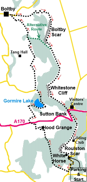
three-way fingerpost (SE 499857). #
Right is for “Little Moor” and the route to shorten the walk to the top
of the escarpment (see sketch map). For the full circuit, keep straight
ahead for Boltby. At a fork, go left.
The rough track gives way to a tarmac lane,
passing Fernleigh Farm.
You get to the junction with the road at
Boltby (SE 892866). It is worth a brief interlude to go left here and stroll
for a few minutes through this tranquil attractive village but our route
goes right here.
%20Boltby%20Church.jpg)
Walk up the road out of Boltby. As the road
curves left, look out for the footpath on the right via a wooden stile
between two stone posts.
The footpath descends to a beck which is
crossed by a small footbridge. Shortly cross a second stream by footbridge,
then begins the hard work!
Climb the hill and at the trees, follow their
left hand edge. The path rises to a short stretch of level ground where you
turn right (SE 502868). A blue bridleway arrow indicates the route. The path
now zig-zags up the hill, guided by the blue arrows, arriving at the top by
farm buildings and where a fingerpost indicates you have joined the
Cleveland Way (SE 507867). Turn right.
%20View%20From%20Above%20Boltby.jpg)
%20View%20Near%20Boltby.jpg)
You now follow the Cleveland way along the
top of the escarpment, passing Boltby Scar and Whitestone Cliff, from where
is a spectacular view of Gormire Lake below. There are some steep drops
along here so do not get too close to the edge.
%20Whitestone%20Cliff%20and%20Gormire%20Lake.jpg)
Stay on this path until you reach the North
York Moors National Park Visitors Centre at the top of Sutton Bank
(SE 514830).
From the Centre car park, cross the A170 and
to the left of the white milestone saying “Thirsk 6 miles”, take the
well manicured footpath to its left. When the path splits, take the left
fork signposted for “White Horse ½ mile”.
%20View%20SW%20nr%20Sutton%20Bank.jpg)
%20View%20NW%20Near%20Sutton%20Bank.jpg)
To the left along here is the Yorkshire
Gliding Club. Gliders/planes land and take off here so do not venture off
the path.
Pass immediately above the White Horse.
Although this famous figure can be seen clearly from various places in
Yorkshire and at some distance, this close to it, it is impossible to make
out its shape because it is so big. You meet the head first and the large
clump of grass is its eye. A sign tells you when you have reached it.
Immediately past the White Horse, turn right
to descend the steep steps back to the car park.
If you need to buy any
hiking equipment/clothing before your trip see the Hiking
Store
All information on this
site is given in good faith and no liability is accepted in respect of any
damage, loss or injury which might result from acting on it.
|


.jpg)
.jpg)
.jpg)