|
Rosedale
Abbey and the Mines
|
Starting
point and OS Grid reference:

Rosedale
Abbey (SE 726960). Free car park on Heygate Bank – take the turn
signposted Egton Bridge.
|
Ordnance
Survey Map
OL26
North York Moors – Western area.
Buy this map from
List
of OS Maps
Note: If you use OS Maps on-line, you can download this route via this
link.
| |
Distance: 11.4 miles
| |
Traffic light rating:

(For explanation see My
Walks page)
| |


For advice on .gpx files see
My
Walks page
|

Click
the PDF logo above to give a printable version of this walk without the
photos.
|
To
view route as a dynamic Ordnance Survey map click here.
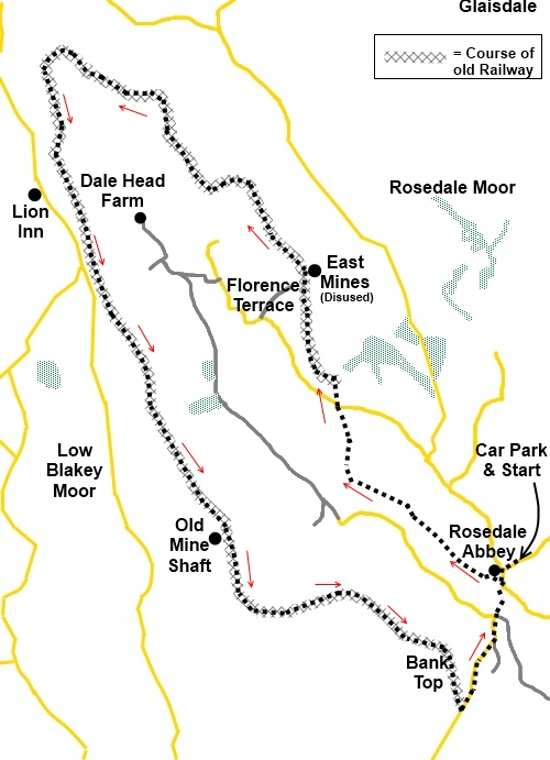
Introduction:
Rosedale was an important centre for
high grade ironstone mining from the 1850s to the 1920s. The mines are
closed but plenty of industrial archaeology remains with information boards.
A beneficial legacy as far as walkers are concerned is that the mining
industry resulted in what is now a disused railway route circling the entire
valley above Rosedale Abbey. This walk takes advantage of this track-bed and
although the walk is quite long it is easy because of course it is level, as
it hugs the contours of the land. It provides great views up and down the
valley and across the North Yorkshire Moors. The monolith of the RAF
Fylingdales radar station some 10 miles away is clearly visible.
The walk starts in Rosedale
Abbey where there is street parking and a free car park, the starting point
for the walk.
Rosedale Abbey is at the
heart of the North Yorkshire Moors and the best way to get there very much
depends on from which direction you arrive. It is best to consult an atlas
or get directions via Google Maps via my Location of Start Points via the “My
Walks” page.
Refreshments are available
in Rosedale Abbey at one of two pubs and tea rooms. There is also a pub part
way round the walk (The Lion at Blakey) and there is Dale Head Farm half way
round which does teas etc (opening variable).
Start:
From the car park (SE 726960), turn right and walk to the village centre. At the
cross roads, go straight ahead to the right of the village green. At the
small grassy triangle, turn right. As you round the corner, look out for the
church on the right with the “stump” which is the only remains of the
Cistercian Priory. Take the footpath opposite (SE 724959) marked with a
fingerpost for Dunn Carr Bridge.
This takes you into the
campsite and its tarmac drive. Turn right. The route through the campsite
and areas “out of bounds” are
clearly marked. As the drive swings to the left go through the kissing gate
straight ahead in the direction of the fingerpost for Dunn Carr Bridge.
Follow the obvious path
until shortly after entering a copse of trees there is a bridge to the left.
Ignore this and at the fork shortly beyond it, go left, crossing some wooden
boarding. Having crossed the boarding, bear slightly right and go through
the gate ahead bearing a yellow waymarker.
You then come to a ladder
stile and after crossing it, look out for a metal gate ahead with a walkers
gate attached. Through this, turn left on a broad track, descending
slightly.
As the track levels out,
look out for a stile on the right with a yellow waymark arrow and cross
this. Follow the right hand bank of the stream until you reach a footbridge
(SE 710968) however do not cross it but turn sharp right and follow the line
of stone slabs across the field towards the power pole in the centre of the
field (you could of course cut the corner if you are sure where you are).
The stone slabs guide you across the field to a stile and a twin plank short
footbridge. Beyond these head for the farm gate ahead.
Go straight ahead through
the kissing gate climbing slightly all the while. Through the next kissing
gate, the track follows the left hand boundary of the field and comes out at
Hill Houses by a row of garages. Follow the gravel track straight ahead.
Cross the road at Hill
Cottages (SE 709976) and go straight ahead on the marked bridleway. As you
pass a white painted house, you get the first glimpse of industrial
archaeology on the left.
As the track turns a
corner, you reach a gate with a blue bridleway arrow pointing to the right
and an information board. Ignore the blue arrow and go straight ahead. You
are now on the track bed of the old railway which you simply follow as it
circles the valley. As you reach an old spoil heap, the track turns left
then immediately right.
%20Rosedale%20and%20the%20railway%20track%20bed.jpg)
As you walk along, on the
skyline on the opposite side of the valley, look out for a cluster of
buildings which are the Lion Inn. There is an opportunity to visit this
later in the walk should you wish.
You pass the defunct workings of East Mines
with an information board and a little further on is a sign (SE 698998)
indicating teas at Dale Farm.
%20Kiln%20Remains%20at%20East%20Mines.jpg)
%20Heading%20Up%20Rosedale%20on%20the%20Old%20Track%20Bed.jpg)
%20View%20Down%20Rosedale.jpg)
Continue to follow the
track round the valley. You come to the remains of an old brick building
with its old window forming an arch at NZ 681004 and the Lion Inn is behind
it reached by a footpath with a fingerpost indicating it at SE 680999. There
is another at SE 683995.
At a crossroad of tracks,
just carry on straight ahead on the level track. Indeed, straight ahead is
virtually the only instruction needed for the rest of this walk.
There is the fenced off
remains of an old mineshaft at SE 697963 and if you stand on a large stone
there, you can just see the hole! After this mine, the track swings round to
the left in a large arc.
%20View%20From%20a%20Bench.jpg)
As you pass behind a row of
cottages, take the gravel path which branches off to the left and at the
road, turn left and walk down the steep hill back into Rosedale Abbey.
%20Rosedale%20Abbey%20in%20the%20Evening%20Sun.jpg)
If you need to buy any
hiking equipment/clothing before your trip see the Hiking
Store
All information on this
site is given in good faith and no liability is accepted in respect of any
damage, loss or injury which might result from acting on it.
|


.jpg)
.jpg)
.jpg)
%20Approaching%20the%20Lion%20Inn%20Turn%20Off.jpg)
%20East%20Mines%20Kilns%20and%20Fylingdales.jpg)