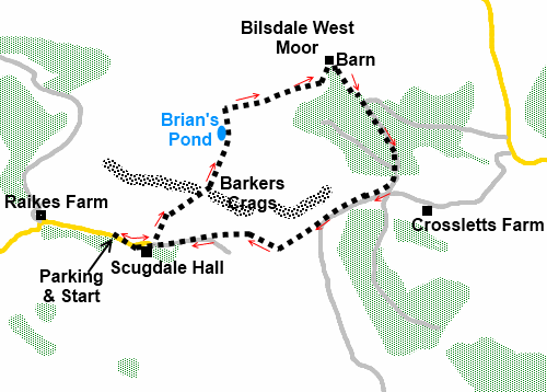
|
Scugdale
|
Starting
point and OS Grid reference:

Rough
lay-by on the left close to Scugdale Hall (NZ
516001)
|
Ordnance
Survey Map
OL26
NY Moors - Western area.
Buy this map from
List
of OS Maps
Note: If you use OS Maps on-line, you can download this route via this
link.
| |
Distance: 2.8 miles
| |
Traffic light rating:

(For explanation see My
Walks page)
| |


For advice on .gpx files see
My
Walks page
|

Click
the PDF logo above to give a printable version of this walk without the
photos.
|

To
view route as a dynamic Ordnance Survey map click here.
Introduction:
I would bet money that if you asked
most walkers where Scugdale was, you would draw a blank. It is a tranquil
cul-de-sac valley, a “time forgot” sort of place, on the edge of the
North York Moors and accessed via the lovely village of Swainby, just off
the A19.
This walk was intended to be a circular walk
taking in part of the Cleveland Way but was dramatically cut short by my bad
fall on Bilsdale West Moor which resulted in torn knee ligaments. The
distance walked was only 2.8 miles, hardly worth putting boots on for but
given the several weeks of suffering which resulted and the fact I had some
quite nice photos of what is a very scenic area, I was determined to publish
it anyway. I will return one day to complete the intended route but this
would be a lovely “stroll” with nice views for anyone with limited time.
It is especially beautiful in the August heather season. [Note did return
and complete, though in reverse order in September 2019. See Bilsdale
West Moor Circuit]
The walk starts at a rough roadside lay-by
just before Scugdale Hall. To get there, turn south east off the A172 for
Swainby. Head along the main street and after leaving the edge of the
village, turn left on to Scugdale Road. Keep straight ahead on this road.
After passing a row of cottages on the left at Huthwaite Green and a road
sign indicating a cul-de-sac, negotiate a 90° right hand bend, a 90° left
hand bend then two more sharp bends close together at Raikes Farm. ¼ mile
after this is the lay-by on the left.
You need to have any refreshments with you
but there are two nice pubs in Swainby afterwards or for lunch before.
Start:
Walk along the road in the same direction as you arrived and just past
Scugdale Hall, turn left on to a bridleway at a fingerpost. There is a sign
“Welcome to Scugdale” (NZ 518001).
%20view%20south%20to%20Whorlton%20Moor.jpg)
As you get close to the top of the bank there
is a path off to the right but ignore this and continue to the top.
%20Barkers%20Crags.jpg)
%20looking%20west%20along%20Scugdale.jpg)
At a ‘T’ junction of paths, turn right.
The path forks with a wider track going off to the right. Take this.
Pass Brian’s Pond (NZ 523007) on the left
and just past this, join a wide stony moorland path and turn right. On the
right shortly afterwards take a fainter track off to the right (NZ 523009).
There is a rudimentary tiny cairn which marks the spot. In the distance you
might spot a post with a white top.
%20Brian's%20Pond.jpg)
%20Bilsdale%20West%20Moor.jpg)
After passing a number of shooting positions,
the path splits. Take the right hand track heading towards the trees. Follow
this to a gate and turn right by a small barn (NZ529011) after going through
it. Go through two gates and follow the path alongside the trees.
%20Moorland%20view%20west.jpg)
On joining a broad stony track, turn right
and follow it through the trees. Exit the trees and midway across the open
space before the next group of trees, take the right turn (NZ 523004).
The track climbs gently and after passing
under some power lines turn right (NZ
528002), passing a fingerpost. Go through a gateway and the track descends
gently back into Scugdale, joining the road at Scugdale Hall. Follow the
road back to the car park.
If you need to buy any
hiking equipment/clothing before your trip see the Hiking
Store
All information on this
site is given in good faith and no liability is accepted in respect of any
damage, loss or injury which might result from acting on it.
|
