
|
|
|
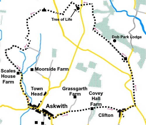
To view route as a dynamic Ordnance Survey map click here. Introduction: This walk from Askwith is not a straightforward outing
and presents a number of challenges, not least the navigational task of
finding your way across Access Land and locating the Tree of Life. There are
a number of inconvenient stiles and gates to negotiate, some of which are
poorly maintained. Odd gates may need to be climbed. In these circumstances,
you should always climb a gate at the hinges end to minimise strain on it. The
walk is nevertheless worthwhile because you get great views across the
Washburn Valley to the Menwith Hill RAF Station ‘Golf Balls’, and great
views from Askwith Moor, across Wharfedale . In
addition, you pass the ruins of Dob Park Lodge. This 17th Century
lodge was used as a viewing point to watch deer hunting. It was painted by
Turner in 1815. It is in a sorry state and although there were relatively
recent plans to turn it into a residence little seems to have happened. The
route described to the Tree of Life is via a gate on to the moors. The gate
is within a hundred yards of the stone on which they are carved but its low
prominence makes it difficult to spot. It has a design more complex than
most ‘cup and ring’ rocks, with many cups and lines. There seems no
specific reason why it has come to be known as the ‘Tree of Life’ other
than through local folklore, or a liberal interpretation of the design. It
is a Scheduled Monument and could be six or seven thousand years old. Please
do not add to its erosion by walking on it! After
passing the Askwith Moor trig. point, you come to the shooting hut. Behind
this are the remains of a stone cross although only the bottom section
remains. The
walk starts from the small village of Askwith, between Ilkley and Otley on
the north bank of the River Wharfe. To get there, from the traffic lights in
the centre of Ilkley, turn downhill, cross the river and turn first right.
From Otley, pass the market square (with it on your right), continue
downhill to cross the river and turn left along Weston Lane. Parking in
Askwith is on street. Please do not block any drives/junctions. Alternatively,
you could do the walk across the stepping stones from Burley nin Wharfedale
though this would add around three miles (including return) to the overall
distance. For directions to Askwith from Burley, see my Burley-in-Wharfedale
to Askwith, Denton and Ben Rhydding walk. Start: With
your back to the Askwith Arms, turn right and walk along the main street. Cross
the low road bridge over East Beck and past further cottages. As the road
bends sharply right, turn off left at the little, round grassy island, along
the lane (Hallam Lane) (SE 174480).
Follow
the lane until, at a sharp left hand bend, you reach a bungalow (Hallam
Cottage). Fork off right here, through a gate, along a footpath indicated by
a yellow footpath arrow for the Welcome Way (SE 178482). Through
another gate, follow the right hand field boundary. There are good views
across the valley to Burley Moor. Cross
a stream via a small wooden footbridge, then across a stile. Bear slightly
left from here, heading for the diagonally opposite corner of the field,
where you cross another stile. Ahead is the end of a stone wall. Pass this
and head for the corner of the right hand barn ahead. Turn left here, with
the barn on your right, in the direction of a home made footpath sign. At
the end of the barns, turn right through a farm gate, following another home
made sign for Clifton. The turn is also marked with a yellow arrow. Cross
the farmyard. The path turns left before leaving it. Just follow the yellow
markings. The
footpath is well trodden through some trees. Exit the trees via a stile then
keep to the right hand boundary. Cross
a farm drive (SE 189484) and go through the slit stile opposite. The
footpath bears slightly right and was well trodden and clear. There was a
sign warning of “Bull in Field” but only sheep were present. At
the far side of the field, cross a stile and head for the buildings which
form Clifton. The footpath enters the hamlet along a short section of narrow, walled footpath before connecting to a gravelled area. In the far left hand corner of the graveled area, climb a couple of steps, then turn right along a row of cottages (Top Row) to meet the road. Turn left along it.
At
the main road, turn left. Take care as this is a busy road, often with
quarry lorries but there is a verge and the distance is only a hundred and
fifty yards or so. Pass
the entrance to the radio mast and immediately after the drive to a house, turn right over a stone step
stile indicated with a public footpath fingerpost. The stile is quite
difficult to spot under the shade of the trees (SE 196485). Once over the stile, head left and follow the obvious footpath across four fields. In the fifth field, head for the far left hand corner and exit into the road. Turn right.
After
about three hundred yards, turn left along a track. Signs at the entrance
indicate properties “Dob Park House” and “Mistal” and there is a
public footpath fingerpost (SE 195496). About half way to Dob Park House, look out for a “two bar” stile on the left. This is between trees and is easy to miss if you are not concentrating. Bear right once over it to the stile in the stone wall which is obvious. The path has clearly been diverted round the properties.
Once past the properties, the path turns right to a walkers’ gate. Once through this, turn left, along a walled track. On the right are the ruins of Dob Park Lodge and in the distance is Swinsty reservoir and the Menwith Hill ‘Golf Balls’.
Enter
a field and cross it, keeping to the right of the windmill. As you get
closer to the boundary wall, you will see a stile. Cross and keep to the
left hand boundary to the next one. Cross
and turn right, following the right hand boundary to Midge Hall farm. The
path is straight across the farmyard and the exit is marked with a yellow
arrow. Beyond
the farm, the path curves left then right through a copse of trees before
crossing another stile marked with a yellow marker. Follow
a broad walled track to another broad track crossing your path. Cross this
and in the field opposite, follow the telegraph poles. At the far side of
the field, cross a stile (it is somewhat obscured by the trees.), and then
bear left to a ladder stile which you can see. Follow
the yellow markers to the right of the barn to the drive to Carr Farm and
turn left along it (SE 184513). At
the road, cross and go through the gate. You are now leaving the public
rights of way. This route to Access Land has been kindly agreed by the
farmer concerned. Please respect his kindness by ensuring you secure the
gate and leave no trace of your passing. Keep
straight ahead up the hill, navigating your way through the rocks. On
meeting the boundary wall at the edge of the moors, turn left to follow it,
going round a small ‘dog leg’ section, until you reach a metal gate (SE
180511). Go
through the gate. You are now very close to the Tree of Life but it is not easy to find. If you have the technology, its OS reference is SE 17978 51161 otherwise, from the gate, heading at 296° (roughly north west), you may be able to make out a faint track. Follow this for about sixty yards then turn right. You should be within a few yards of the Tree of Life stone.
Return
to the faint track and turn right. You should be heading at about 330°, a
little west of due north. After about a hundred and fifty yards, you should
meet another slightly less faint track at a ‘T’ junction, clearly used
by wheeled vehicles occasionally. Turn left along this. After just over a quarter of a mile, you will come to a small angular rock on the left, next to the track and you are at about a hundred yards from the road which will be obvious from the traffic (SE 176509). This rock marks the position where another small track/footpath turns off on the right. Follow this to a gate by the road.
Cross
the road and go through (or climb over; it may be locked) the opposite gate
to join a broad stony track (SE 179510). You will be pleased to know the
remaining navigation across Access Land is more straightforward! Follow this track to a shooting hut, passing on the way the Askwith Moor trig point to the left of the track.
From the shooting hut, a number of broad tracks radiate. The one you want is beyond the hut, leaving the area of the hut between 10 and 11 o’clock, relative to your approach to the hut, or at 220° (South West).
Follow
this clear track until it meets a farm gate. Strictly speaking, you should
pass down the right hand side of the fence, remaining on the Access Land
until you reach the bottom corner, where there is a Right of Way (ROW) for a
left turn. However the gate there is in very poor condition and secured in a
way which makes it impossible to open. It is therefore safer to climb the
first gate and proceed down the field to the bottom wall, where you join the
ROW. Turn left for a few yards then turn right through a gateway and drop
down to Top Moorside Farm. Turn
right and curve right through the farmyard, then left down the hill but only
for a few yards. Turn right through a gate to follow a rutted track along
the left hand border of the field. Through the trees, you might catch
glimpses of a pond. Go
through a gate, following a yellow footpath arrow, passing to the right of
Whin Hill Farm (SE 163500). It is now a simple matter of following its drive
(which changes from stony to a tarmac lane eventually) downhill back to
Askwith. Turn left when you reach the road junction, back to the centre of
the village. If you need to buy any hiking equipment/clothing before your trip see the Hiking Store All information on this site is given in good faith and no liability is accepted in respect of any damage, loss or injury which might result from acting on it.
| | |||||||||||||||||

.jpg)
.jpg)
.jpg)
%20View%20to%20Burley%20Moor.jpg)
%20Top%20Row%20Clifton.jpg)
%20View%20across%20the%20Washburn%20Valley%20to%20the%20Norwood%20Edge%20radio%20mast..jpg)
%20View%20along%20the%20Washburn%20Valley%20to%20Menwith%20Hill%20RAF%20station.jpg)
%20stile.jpg)
%20Dob%20Park%20Lodghe%20with%20Swinsty%20Reservoir%20and%20Menwith%20Hill%20in%20background.jpg)
%20Tree%20of%20Life.jpg)
%20Looking%20down%20Washburn%20Valley%20from%20the%20Tree%20of%20Life.jpg)
%20Rock%20marking%20the%20right%20turn%20referred%20to%20in%20the%20text.jpg)
%20Menwith%20Hill%20with%20heather%20from%20Askwith%20Moor.jpg)
%20Track%20across%20Askwith%20Moor.jpg)
%20Askwith%20Moor%20trig.%20point%20with%20shooting%20hut%20behind.jpg)
%20Cross%20remains%20at%20shooting%20hut.jpg)