
|
|
|
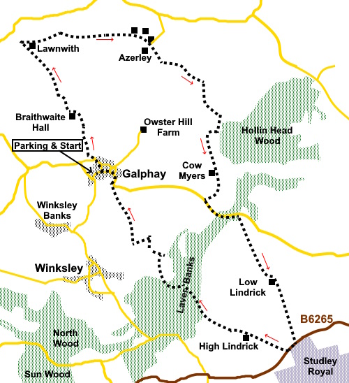
To view route as a dynamic Ordnance Survey map click here. Introduction: This circular walk starts from the attractive village of Galphay in the Nidderdale Area of Outstanding Natural Beauty. The walk is a mixture of passing through extensive agricultural land, woodland, by streams. The River Laver is crossed via Woodhouse Bridge, which is a Grade II, late 18th Century Listed Building with three arches. Galphay has a large village green with a flagpole and a nice looking pub. The village name is believed to stem from two parts Galga and Haga. Both words from the Dark Ages. The latter means enclosed field. Galga is an old English word referring to Gallows. So, Galphay was the Gallows Field! The walk passes the delightfully named Witch of the Woods house, a 17th Century house. It is so named on the Ordnance Survey map. One can only guess how it got its name. It also passes the unusual Braithwaite Hall, another Grade II Listed Building. It is thought to date from the 16th Century with periodic additions and restorations. The walk starts from the larger of two village greens in Galphay where there is room to park. The village is surrounded by a number of fairly tortuous lanes but the easiest route to describe is to leave the A61 at Ripon via the B6265 signposted for Pateley Bridge. After one and three quarter miles turn right on to Galphay Lane. Galphay is signposted. You will pass the Galphay Inn and the village green is just beyond. To get there any other way, good luck! Start: From the village green, walk along the road, passing the pub.
After passing the village hall, go through some gates to Braithwaite Hall.
Just after passing Braithwaite Hall, fork right along the gravel track. It turns to grass and you will reach two gates. Go through the right hand gate following the blue bridleway arrow. The path starts more or less down the centre of the field and continues in a straight line which, as the field widens, is more to the left of the field. At the end of the field, go through a gate and join a broad track. Turn left. Pass through the farmstead of Lawnwith then pass a wood. At the far side of the wood, turn right through a kissing gate following the edge of the wood in the direction of a yellow footpath arrow.
Cross a stile at the end of the wood and bear left, again following a yellow footpath arrow, to the opposite corner of the field at SE 245744 . Cross a stile and follow the right hand boundary of the next two fields. Cross a stile, the path is then straight across the next three fields. Cross a stile next to an ornate iron gate at Azerley (SE 256745), then keep right to follow the stream. Keep right at the next fork.
Continue through the woods, passing a house, then straight across a broad track.
After
Home Farm, the track splits, take the right hand fork. There is no Right of
Way to the left – a notice advises. The
track opens into a field and splits. Follow the main track. There is a small
stone bench at the junction. Follow the left hand boundary. Cross a footbridge and keep in the same direction across the first section of field to the far boundary. Bear right to follow the boundary as it curves right passing Witch of the Woods house (SE 268731).
About
half way up the field, bear left
to a gateway (SE 267730). Join a broad track and turn left. Follow
this clear broad track straight through Cow Myers farm, reaching the road at
SE 266 722. Turn left. Follow
the road for a third of a mile. Just beyond some woods, turn right (avoid
the tempting track into the woods!). There is an old fashioned metal sign
indicating a bridleway (SE 271720) Stay on
this track passing the farm buildings at Low Lindrick, for almost a mile and
a quarter to arrive at the road opposite a grand but now rather rough
gateway. This is them rear entrance to Studley Park but you cannot get in
this way. Turn
right along the road, keeping to the right hand verge. This is a very busy
road but the verge is wide and you only follow it for about a hundred and
fifty yards, where you turn right along a lane following an old stile
bridleway sign. When the lane splits, take the right fork along an wide gravel track. There are some long distance views to the North York Moors.
Keep
straight ahead at the farm. At a
fork, keep right following a public footpath fingerpost. Go left
at the next junction (SE 265709), through the trees and follow the main
track avoiding any turns off. Cross Woodhouse Bridge (SE 262712).
Exit the
woods by an abandoned farmhouse (SE 261712), passing through a gate marked
with a yellow footpath arrow. Enter a
field and head fin the direction of the diagonally opposite corner, passing
to the left of a line of trees across the field. As you pass the trees, bear
right to a corner (SE 260715), then follow the left hand boundary. At the end of the field, there is a field marked private According to my map, the footpath should go straight ahead here but the path has been diverted (not sure if officially). Turn left here in the direction of the yellow arrow. In practical terms, you are going round the same rectangle so it is no further.
About
two thirds of the way up the field, turn right through a walkers’ gate (SE
2590 7160) and follow the right hand boundary. At the
end of the field, turn left, following its right hand boundary. In effect
you are walking rough the edge of the field to avoid crop damage. At the
top of the field (SE 257717) things are a bit tricky. The footpath is over
the fence directly ahead then a right turn to follow the right hand
boundary. However, I could not see a stile and the crossing would have been
into a copious nettle bed. I therefore turned right following the boundary
now on the left to the end of the next field turning left to join the path
proper next to a stile. From
that stile, as if you had followed the proper path, keep straight ahead
(North), passing to the left of a power pole to a stile beyond. Cross and
carry on to a kissing gate you can see. Cross a
farm track and go over a stile and keep straight ahead, crossing a stream.
Cross a
stile keeping straight ahead in the direction of the yellow arrow. Continue
until you reach the road then turn left back into Galphay. If you need to buy any hiking equipment/clothing before your trip see the Hiking Store All information on this site is given in good faith and no liability is accepted in respect of any damage, loss or injury which might result from acting on it.
| | |||||||||||||||||

.jpg)
.jpg)
.jpg)
%20Galphay%20Inn.jpg)
%20Braithewaite%20Hall.jpg)
%20Field%20view%20near%20Lawnwith.jpg)
%20Ornate%20gate.jpg)
%20Field%20View.jpg)
%20Witch%20of%20the%20Woods%20House.jpg)
%20Forgotten.jpg)
%20View%20to%20the%20North%20York%20Moors.jpg)
%20River%20Laver%20at%20Woodhouse%20Bridge.jpg)
%20Woodhouse%20Bridge.jpg)
%20Sky.jpg)
%20Ruin%20near%20Galphay.jpg)
%20Wild%20flower%20meadow.jpg)