|
Gargrave
to Airton
|
Starting
point and OS Grid reference:

Gargrave
- free car park on North Street (SD 932543)
|
Ordnance
Survey Map
OL2
Yorkshire Dales – Southern and Western Areas.
Buy this map from
List
of OS Maps
Note: If you use OS Maps on-line, you can download this route via this
link.
| |
Distance: 8.8
miles
| |
Traffic light rating:

(For explanation see My
Walks page)
| |


For advice on .gpx files see
My
Walks page
|

Click
the PDF logo above to give a printable version of this walk without the
photos.
|
To
view route as a dynamic Ordnance Survey map click here.
Introduction:
Gargrave is a “honeypot” village between Settle and Skipton on the A65
in North Yorkshire, very popular with day trippers. Contrary to what many
believe, it is not within the Yorkshire Dales National Park boundary, which
is why I have listed this walk under North Yorkshire, although most of it
does fall within the National Park. The walk is a very easy one through
pleasant rolling countryside with nice views, especially of Flasby Fell and
in part follows the course of a youthful River Aire which later, having
grown in stature, flows through the City of Leeds. The walk also passes the
attractive village of Airton, formerly a Quaker village, so no pub! A
majestic mill building by the river has now been converted into apartments.
Refreshments and public
toilets are available in Gargrave along the A65.
Some road walking on quiet
lanes is involved.
The walk starts from a free
car park in Gargrave. To get to it, turn off the A65 at the Old Swan Inn on
to North Street. The car park is a hundred yards or so on the right hand
side.
Start:
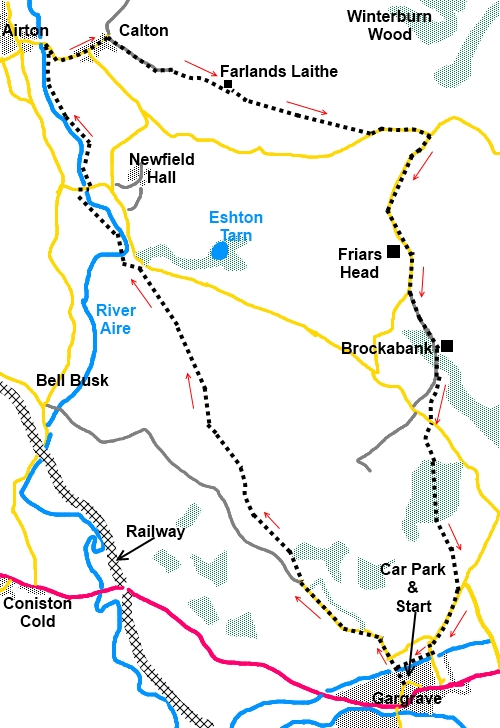
At the corner of the car park (SD 932543), there is a multi-fingerpost with
one pointing to the Leeds Liverpool Canal along West Street. Follow this
direction and cross the canal, then keep straight ahead.
At the road junction (SD
931545), straight ahead again, along Mark House Lane. Continue along the
lane round a couple of bends and keep going until you reach a clear finger
post on the right bearing the long distance footpath acorn symbol signing
the Pennine Way and Airton 3 miles (SD 924551).
The track across the field
is reasonably clear and initially parallels the lane before heading to the
right of a barn on a small hill then swinging left. Go through a kissing
gate and the path then climbs the gentle hill to the corner of the trees
where a fingerpost confirms the Pennine Way route.
Follow the fence line along
and go through the kissing gate then head for the gate opposite. The
path then goes to a point just to the left of the trees then follows the
line of the wall on the right.
Go through the gate in the
corner and follow the direction of the finger post for the Pennine Way.
Go through a double set of
gates and head downhill to the right of the wall ignoring any turns off. In
the corner of the field, by the road, go through the kissing gate (SD
912575) staying with the Pennine Way and
“Airton 11/3 miles”
signs (do not go on to the road).
The path goes left through
a walkers gate and follows the River Aire for a short distance to a
footbridge. Cross the footbridge and continue to follow the course of the
river until you get to a road (SD 907581). Turn right, cross Newfield Bridge
over the river then go immediately left to continue to follow the river.
%20Newfield%20Bridge.jpg)
At the next bridge, go up
on to the road where you can turn left along the road to have a look at
Airton and the impressive mill building but our route turns right along the
road, leaving the Pennine Way.
%20Converted%20mill%20buildings%20at%20Airton.jpg)
%20River%20Aire%20Meadow%20at%20Airton.jpg)
Stay on the road to the
village of Calton. As the road bends right, go straight ahead on the “no
through road”
(SD 908591). As the road/track divides at Manor Farm, go
right. You get to a confusing conglomeration of gates and farm buildings,
just keep straight ahead on the main track. As it divides SD 913590), bear
left following the finger post for “Cowper Cote 1 mile”.
The route becomes a little
walled lane before opening into a field. Keep straight ahead where a post
with a walkers arrow confirms the route. The path passes in front of an old
stone barn (Farlands Laithe) then through a walkers gate and straight ahead
over a stile at the bottom of the field then to the left of the farm
buildings you can see on the near horizon, which is Cowper Cote.
Go over the ladder stile to
the left of the farm then over a second and keep straight ahead in line with
the two stiles. After passing under the power lines, the path swings
slightly left then down to a small stile to the right. Do not follow the
power lines.
Once over this stile, head
to the opposite corner of the field where a small gated step stile next to
the large gate takes you into the road (SD 930585).
Turn left and walk along
the road to the junction just over a small bridge (SD 934585) then turn
right staying on this road for about ¾ mile. You pass the fantastic Friars
Head farmhouse, a 17th Century farmhouse
with great mullion windows. It is said to stand on the site of a monastic
farm that once belonged to the monks of Furness Abbey.
%20Friars%20Head.jpg)
About 250 yards past Friars
Head, as the road bends right, go left (in effect straight on) through a
walkers gate (SD 933573). As you approach the trees, the footpath goes
around the left hand side. There is an old lime kiln to the left.
As you approach the house (Brockabank),
go through the gate to its right. The path then curves left in front of the
house and when you reach its drive, turn right along it, crossing the river
by a stone bridge. As the track starts to rise towards the next farm, go
through the walkers gate on the left (SD 934565). Keep straight ahead
ignoring any paths off until you reach the road. At the road the route is
almost straight ahead. A finger post indicates Gargrave 1¼ miles.
Go across the field to a
stile in the left hand fence. Cross it and walk to the left of the power
pole nearest to you at which point you should see another stile going into
the trees via a kissing gate (SD 935560). The path through the trees is
clear.
As you exit the trees, head
slightly left. Flasby Fell looks down on you from the left. Head for what
looks like a jumble of posts/fence tensioners where there is quite an
unusual metal stile. Cross and head for the far left corner of the field and
on to the road. Turn right until you get to the Leeds Liverpool Canal. Go
right and walk along the towpath to the next bridge. Go left along the road
back to your starting point.
%20Leeds%20Liverpool%20canal%20and%20Flasby%20Fell.jpg)
%20Canal%20locks%20at%20Garvrave.jpg)
If you need to buy any
hiking equipment/clothing before your trip see the Hiking
Store
All information on this
site is given in good faith and no liability is accepted in respect of any
damage, loss or injury which might result from acting on it.
|


.jpg)
.jpg)
.jpg)