
|
|
|
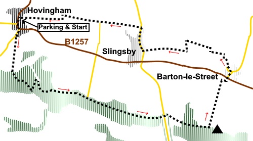
To view route as a dynamic Ordnance Survey map click here. Introduction: This is an easy walk along the northern edge of the Howardian Hills, an Area of Outstanding Natural Beauty (AONB), which is comparatively little visited. There are good views North, through the trees, to the North York Moors. Along the way, in the woods, are the remains of ancient earthworks which you can just about make out amongst the shrubbery. It is an area given over to woodland and arable and pasture fields. There are a number of quiet pretty villages and this walk visits three, Hovingham, Barton-le-Street and Slingsby, in that order. Hovingham
is a small market town. It has been
home to the Worsley family since 1563. They built Hovingham Hall in the
1700s. Roman remains have been found in the locality of the village. The
parish and Methodist churches were built in the 19th Century.
There is a large village green area, one or two shops and a hotel and pub. Barton-le-Street is a small
village with a large village green and not a great deal else, except for St.
Michael’s Church. This is unremarkable in itself, having been built in the
1870s but it contains over 250 pieces of Romanesque sculptures taken from
the previous church dating from 1160. The name Barton evidently comes from
the old English for barley farm. Slingsby as an identifiable
village began life in the 9th or 10th centuries. The
name stems from Old Norse Selungesbi
or Eslingesbi. After some to-ing and fro-ing through the centuries, the land
passed to the Mowbray family in the 12th Century. They
constructed a fortified manor house which later became Slingsby Castle
during the 16th Century. The ruins of Slingsby Castle can be
spotted through the trees but it is in a dangerous state and not open to the
public. There is a village green complete with multicoloured maypole. If you
want a glimpse of the castle, walk along the road to the right of the
village green, as you approach it on this walk, before continuing the route. The walk starts in Hovingham, where there is an ‘honesty box’ car park outside the village hall. Hovingham sits on the B1257 between Malton and the A170 and the best way to get there depends very much on which direction you are coming from, so I suggest using the blue Google icon at the top of the web page for the walk. Start: Exit the car park and turn left along the main street. Immediately after it turns the corner, turn right on a minor road, signposted for Sheriff Hutton and York. There is also a tourist sign for Yorkshire Lavender.
Just as you reach the National speed limit sign, turn left along the bridleway following the sign for “Ebor Way” (SE 667753).
After half a mile, the route enters the trees. This is possibly the most difficult navigational part! The track curves left until you reach a fork. Continue following the main track left. Avoid any turns off, most of which are marked as private access. As the track takes quite a sharp right turn, turn off left, following the blue bridleway arrow on a post at the edge of the trees. The bridleway drops down to a gate. Go through this and turn immediately left to follow a yellow arrow. The arrow is only visible once through the gate. The path follows the edge of the trees. Arrive at a ‘T’ junction of paths (SE 672741) and turn right, crossing the stream and shortly bear right to follow the fingerpost for the “Centenary Way”. The path through the trees is now obvious. Arrive at the end of a tarmac road (SE 685737). Continue straight ahead, following the fingerpost for “Centenary Way” and “Coneysthorpe 3 miles”.
Meet a road (SE 704732) and again, keep straight ahead following “Centenary Way” and “Coneysthorpe 2 miles”. Go through a gate, where there is an information board about the area. Keep straight ahead, ignoring a track off left. The path curves left, following the edge of the trees. In just under half a mile, meet a three way fingerpost. Turn left for “Barton-le-Street ¾ mile” (SE SE 716729) (note, if you reach a trig point, you have missed the turn!).
Follow the path downhill in a straight line until your way is blocked by a hedge, at the bottom of a large field. Turn right here and then shortly left to the main road.
Cross straight over the road into the village, going left at the next junction. Walk through the village, passing the church and village green. At the end of the green, turn left following the fingerpost for “Slingsby”. The lane bears right in front of a long, single storey building. Go through the farmyard following the signs and the broad stony track, until you reach some power lines. Turn left here following the sign for Slingsby (SE 720748). The route initially follows the power lines. At the end of the field, turn right following a blue bridleway arrow. After about fifty yards, turn left, following another sign for Slingsby. Arrive at a rather confusing junction of paths where there are two gates. The footpath route is straight ahead, to the left of the two gates. The path exits on to a broad stony track. Turn left along it, to a ‘T’ junction and turn right to follow the lane into Slingsby.
Follow the road round to the right, in the direction of the road sign for South Holme 1½ miles and Kirkby Moorside 9 miles.
Walk straight through the village. Opposite the caravan site on the right, turn left to follow the course of the disused Railway and crossing a wooden bridge. On reaching a tarmac lane, keep more or less straight ahead following an old style fingerpost. Follow the obvious path, turning left when you reach a marker post. About a hundred yards later, turn right over a wooden bridge to reach Hovingham. The path comes into Hovingham, next to the car park. If you need to buy any hiking equipment/clothing before your trip see the Hiking Store All information on this site is given in good faith and no liability is accepted in respect of any damage, loss or injury which might result from acting on it.
| | |||||||||||||||||

.jpg)
.jpg)
.jpg)
%20Centre%20of%20Hovingham.jpg)
%20Looking%20back%20along%20the%20Ebor%20Way%20to%20Hovingham.jpg)
%20Hazy%20View%20Towards%20The%20North%20York%20Moors.jpg)
%20View%20over%20hayfield%20to%20North%20York%20Moors.jpg)
%20Descending%20to%20Barton%20le%20Street.jpg)
%20Hay%20ready%20for%20collection%20near%20Barton%20le%20Street.jpg)
%20Village%20green%20at%20Slingsby.jpg)
%20Main%20Street%20at%20Slingsby.jpg)
%20View%20towards%20the%20Howardian%20Hills.jpg)