|
Howsham
to Kirkham Priory
Starting point and OS Grid reference:

Howsham
Bridge (SE 732625)
|
Ordnance Survey Map
OS Explorer 300 - Howardian
Hills & Malton.
Buy this map from
List
of OS Maps
Note: If you use OS Maps on-line, you can download this route via this
link.
| |
Distance:
7.6 miles
|
Date of Walk:
8 August 2018
| |
Ascent:
Descent:
See Walking Time Calculator
|
866ft (264m)
865ft (264m)
| |
Traffic
light rating:

(For explanation see My
Walks page)
| |


For advice on .gpx files see
My Walks page
|

Click
the PDF logo above to give a printable version of this walk without the
photos.
|
To
view route as a dynamic Ordnance Survey map click here.
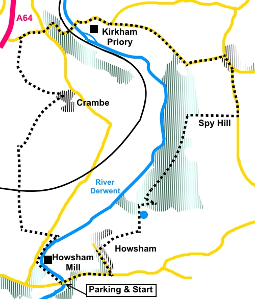
Introduction: This walk is a leisurely circular ramble
in the Howardian Hills of North Yorkshire. It starts near the historic
Howsham Mill and goes via the sleepy hamlet of Crambe before arriving at
Kirkham Priory, where there is an excellent lunch stop available at the
Stone Trough pub. There is then a short section of about a mile and a half
of road walking before crossing Spy Hill to enjoy the views.
Howsham Mill is an ornate
Georgian Gothic edifice on a small island in the River Derwent originally
built in 1755, to mill flour for the Howsham Estate. This activity continued
until 1947 after which it became derelict. Between 2003 and 2006, the
Renewable Heritage Trust restored the mill. It is now used as an
environmental education centre and also generates hydroelectricity using an
Archimedes screw. This can be seen from the riverside path which my route
follows.
Crambe is a quiet hamlet,
its main street dominated by the tower of St Michael’s Church. There is
not much to see here but it is worth a wander, just to experience the
tranquillity of the place.
Kirkham Priory is Grade 1
listed and under the care of English Heritage and can be explored by payment
of a modest charge. It was an Augustinian Priory until, as with most such
places, Henry Viii came along with his wrecking ball! The most impressive
part of the site is probably the medieval gatehouse. You get a good view of
this in passing, without having to pay!
The walk starts from a
rough lay-by adjacent to Howsham Bridge. The easiest way to describe the way
there, is to turn east off the A64 dual carriageway for Barton-le-Willows
(signposted). In the village, turn right at the give way sign, then continue
to follow this road, soon coming to a road sign for Howsham 2 miles. Stay on
this road until you reach the river bridge over the River Derwent. There is
a yellow Private Fishing sign opposite the lay-by, adjacent to the
walkers’ gate through which the walk starts. There is a bit more parking
immediately across the bridge.
A word of warning. There
was a section of footpath badly blocked by brambles. I was able to get
through at a cost of scratched legs (it was shorts weather!) but a pair of
secateurs would have been handy! The offending section has been reported to
North Yorkshire County Council on 26 August 2018 and acknowledgement
received but if there is still a problem at the time of your walk you might
like to repeat the exercise.
Start: From the parking area (SE 732625), go
through the walkers’ gate following the fingerpost for “Kirkham Abbey 3
miles”. Follow the path alongside the river and through a kissing gate at
the end of the first field.
Continue by the river,
passing at the other side of the water, Howsham Mill and its Archimedes
screw.
%20Howsham%20River%20Bridge.jpg)
%20Howsham%20Mill.jpg)
Continue to follow the
riverside path until you get to another walkers’ gate. Here, if you look
left, not especially clear in the trees, there is another gate (SE 732631).
Go through this and turn right following a yellow arrow and the right hand
boundary of the field.
Follow the path to the
road. The continuing route is straight across the road. The walkers’ gate
was somewhat buried in the hedge. This is the section where you might need
the secateurs!
%20Path%20blocked%20by%20brambles.jpg)
On reaching the farm
(Crambe Grange), keep straight ahead through two gates.
%20Wildlife%20at%20Crambe%20Grange%20(Alpacas).jpg)
At the end of the next
field, turn right at the corner and through another walkers’ gate (SE
727632).
Follow the path into the
field and follow the hedge on the right hand side. Part way along the field,
there is a gap in the hedge and a fingerpost for “Crambe”. Go through
the gap and turn left, now following the left boundary of the field.
Keep straight ahead to
the railway line which you need to cross with care (SE 727637).
At the end of the first
field, cross the access track to Clay Hall. Keep straight ahead, crossing
another track to Hilside Farm. Follow the left boundary of the field to
arrive at a third very clear broad track (SE 727643) and turn right along it
to Crambe hamlet. You will pass a fingerpost for a bridleway on the left to
“Whitwell-on-the-Hill ½ mile” but ignore this and continue straight
ahead on the main track.
%20Wide%20open%20spaces%20near%20Kirkham.jpg)
Shortly after going
through a gate, turn right on a grassy path to follow the fingerpost for
“Crambe ½ mile”. The path leads down through a small clump of trees and
up a bank at the other side.
At the road, turn right
for a look at Crambe, though continuation of the route is left at this point
and after going through a gate, there is fingerpost straight ahead for
Whitwell-on-the-Hill. However, despite the direction of the arrow, the path
is actually from the top right hand corner of the field. Go through the gate
here and follow the left hand boundary of the fields as they curve right.
%20Centre%20of%20Crambe.jpg)
Threatening%20skies%20near%20Kirkham.jpg)
At the road (Onhams
Lane), turn right for Kirkham.
As you cross the railway
line, you may notice the blue plaque on the signal box. This indicates that
the signal box was awarded a National Railway Heritage Award (NRHA) in 2011
for its refurbishment.
%20Award%20winning%20signal%20box%20at%20Kirkham.jpg)
Continue along the road,
passing and maybe patronising Kirkham Priory and the Stone Trough pub.
Continue on the road to the village of Westow, turning right at the ‘T’
junction and passing the Blacksmith’s Arms.
%20Kirkham%20Priory.jpg)
%20Gatehouse%20at%20Kirkham%20Priory.jpg)
About half a mile after
the pub, look out on the right for a broad track, just after a traffic sign
warning of oncoming vehicles in the middle of the road and indicated by a
fingerpost for “Howsham 2 miles” (SE 755646).
Follow the right hand
boundary of the field and over Spy Hill, from where as the name might
suggest, there are good views.
%20View%20at%20Spy%20Hill.jpg)
%20View%20at%20Spy%20Hill.jpg)
Go straight over Spy Hill
and down the other side, until you meet a fence. Turn left to follow it.
Go through a gate at the
end of the field and turn left along a forest track.
The track divides at a
bench. Take the right hand path (SE 746641).
At ‘T’ junction of
paths, turn right.
As you get close to the
end of the trees, look out for a walkers’ gate on the left. Go through
this and follow the path down, to cross a stream by a small lake (SE
742634). Beyond the lake, follow the path to a gate/style in the top right
hand corner. Cross the stile and turn left to follow the left hand boundary
of the field.
Go through the gap at the
end of the field, then turn right to follow the right hand boundary. Go
through a number of gates until you join the drive to an attractive bungalow
and turn left.
%20St%20Johns%20Church,%20Howsham.jpg)
%20War%20memorial,%20Howsham.jpg)
At the road, turn left
(SE 737629), through Howsham village and right at the next road junction to
return to the parking.
If you need to buy any
hiking equipment/clothing before your trip see the Hiking
Store
All information on this
site is given in good faith and no liability is accepted in respect of any
damage, loss or injury which might result from acting on it.
|


.jpg)
.jpg)
.jpg)