
|
|
|
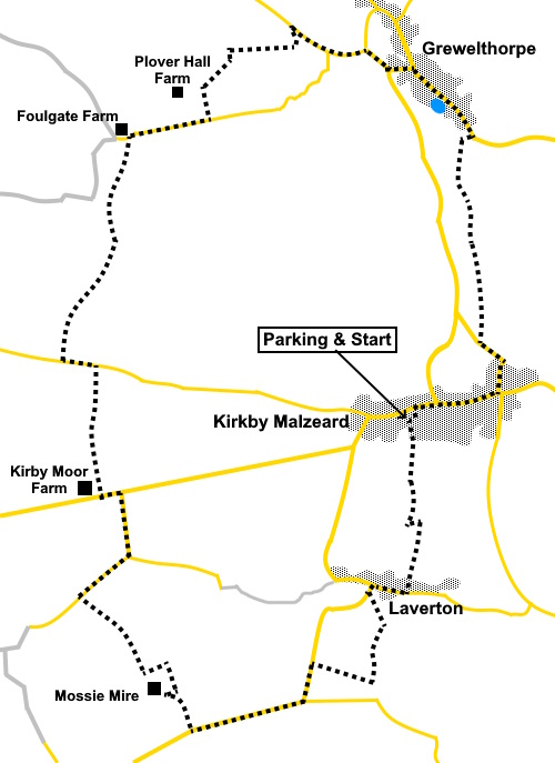
To view route as a dynamic Ordnance Survey map click here. Introduction: This is an easy circular walk through pleasant North Yorkshire countryside, starting at Kirkby Malzeard and passing through the pleasant hamlet of Laverton and Grewelthorpe village with its pretty duck pond. Kirkby Malzeard is officially a ‘town’ having been granted the right to hold a market by Edward I in 1307. Its name comes from two sources; Chirchebi, as it appears on the Domesday Book (meaning ‘church village’), which became Kirkby and Malzeard (meaning ‘bad clearing’ in Norman French. It owes its origins to farming and animals were brought to the market for sale. There is a pinfold where they were corralled. At one time it had a castle but this seems to have been demolished in 1173/4. There has been a church ay Kirkby Malzeard (St. Andrews) since around 1150 with subsequent additions. It suffered a bad fire in 1908 but was restored. The school building was built by subscription in 1862 and is still in use. You will pass it, opposite the church. There
is a Mechanics Institute which serves as a village hall and is one of the
few remaining in the country serving its original purpose – in brief to provide technical, scientific, and literacy education to
working-class men. Laverton’s origins may be older
than Kirkby’s as evidence has been found of Iron Age and Roman occupation.
It was a centre for straw plaiting and bonnet making, alongside traditional
trades like tailors, shoemakers, and blacksmiths. The village centres around the old
packhorse bridge. Grewelthorpe, known by some as
just Thorpe, is believed to have been settled by the Danes. There was also a
Roman encampment on the outskirts of the village. In the mid 19C, it was
famous for its cream cheese. Grewelthorpe has a very pretty
duck pond on which children used to ice skate in the days when we had
‘proper winters’. The walk starts from a small parking area outside the sports ground on Back Lane in Kirkby Malzeard. Kirkby Malzeard is west of a line from Ripon to Masham and you are best advised to consult an atlas or sat. nav. as a description of how to get there could be complicated! It is signposted from the centre of Ripon. From Masham, follow the signs for Grewelthorpe then to Kirkby Malzeard from there. Some of my photos are not of anything in particular, just pleasant countryside pictures to give you some idea of what to expect. Start: From the parking (SE 230742), follow the lane between the houses and the clubhouse. At the end of the houses, go through a walkers’ gate and follow the right hand boundary of the field. After crossing a stile, follow the right hand boundary until you get to a dilapidated wall then bear left to a farm gate half way along the field boundary where you join a lane. Turn right. Follow the lane to a ‘T’ junction where you turn right, Passing through part of the hamlet of Laverton. At the next road junction, turn left over the bridge and immediately turn left through a slit stile, marked with a public footpath fingerpost. Follow the river for a short distance until you come to a stile. Cross this and follow the fenced/hedged footpath beyond. Cross a stile and follow the left hand boundary in this and the next field. About three quarters of the way across this field, turn right to the left hand of two farm gates (SE 228728). Beyond the gate, follow the right hand boundary to the road where you turn left.
Follow the road to a junction and turn right. Stay on this road for just under half a mile and turn right up a farm track, over a cattle grid to Mossie Mire (SE 218725).
Pass the first dwelling on the right and just before you get to Mossie Mire farm, look out for a yellow arrow on the right. This actually points back the way you have come but it serves as the entrance to a fenced footpath which has been diverted from what was shown on my OS map and now runs in a rectangular shape anti-clockwise around a field to avoid the farmyard/house. Just follow it until your way is blocked by fairly newly planted trees and turn right through the gate there (SE 215728).
Follow the right hand boundary of the field to the bottom then bear left to a footbridge over the River Laver. Cross a stile and continue ahead up the hill in the direction of the yellow arrow. You will spot a short section of track in the corner of the field which takes you to the lane (Appleby Lane on the map) and turn right along it. At the road junction just under a quarter of a mile later, turn left. At
the next junction turn left again but only for a hundred and fifty yards or
so. Before reaching the first
farm on the right (Kirby Moor Farm), turn right to follow a public bridleway
fingerpost. Keep
to the right hand boundary of all fields until you reach another lane. Turn
left. After
about three hundred yards, turn right up a broad track, following a public
bridleway fingerpost. At a ‘T’ junction with another broad track, turn
right. At a
barn, follow the blue bridleway arrow through a gate. Continue
to follow blue bridleway arrows until you get to a stream which you have to
paddle across (it was not very deep on my visit). Once over the stream, bear left and follow the field boundary up the hill to Foulgate Farm, part way up the field, you cross another bridleway but ignore this. At the lane, turn right (SE 215758). Follow the lane for just over a quarter of a mile, passing the entrance to Plover Hall Farm. Turn left at the next farm gate you come to. Unfortunately this is not marked in any way. OS reference is SE 219759.
You pass
a dew pond and go through a gate into a field. From the gate, head for the
diagonally opposite corner, then turn left to Oak Stile Farm. Things
became a little tricky here as it was not too obvious which side of which
barn you were supposed to go, due to lack of signs/arrows and obstructions
and there was no one around to ask. I finished up turning right after the
first barn and squeezing past the obstructions into the field beyond. The
footpath route then goes through a gate immediately opposite, in effect
cutting across the corner of the field. The
route then goes across the field, just to the left of a power pole but in
the hedge beyond, there appeared to be no way through. I therefore turned
left to a rickety gate (SE 223765) and through it joined the lane I was
aiming for, turning right along it. At the
junction, go straight ahead, following the road sign for Grewelthorpe. At the
next junction, keep right, following the Masham sign. Left at the next
junction. Arrive
at the triangular village green and turn right along the main street, to
pass the pretty duck pond.
Walk through the village and as you get to where the national speed limit signs are, turn right up some steps. Enter a field and head for the diagonally opposite corner, where you cross a stile next to a ruined building.
The path
is now obvious and follows the right hand boundary of the following fields
before crossing a broad track and dropping down through a small copse of
trees to the road. Turn left and follow it to the market cross where you turn right along main street.
Turn left along a road called ‘The Green’. First right will return you to the car park. If you need to buy any hiking equipment/clothing before your trip see the Hiking Store All information on this site is given in good faith and no liability is accepted in respect of any damage, loss or injury which might result from acting on it.
| | |||||||||||||||||

.jpg)
.jpg)
.jpg)
%20Kirkby%20Malzeard%20circular.jpg)
%20Kirkby%20Malzeard%20circular.jpg)
%20Kirkby%20Malzeard%20circular.jpg)
%20Kirkby%20Malzeard%20circular.jpg)
%20Kirkby%20Malzeard%20circular.jpg)
%20Kirkby%20Malzeard%20circular.jpg)
%20Duck%20Pond%20at%20Grewelthorpe.jpg)
%20Ruined%20building.jpg)
%20St%20Andrews%20Church%20Kirkby%20Malzeard.jpg)
%20Market%20Cross.jpg)