|
Lindley
Wood Reservoir Walk
|
Starting
point and OS Grid reference:

At
turn off on Otley to Bluberhouses road (SE 196492)
|
Ordnance
Survey Map
OS Explorer Map 297 - Lower
Wharfedale & Washburn Valley.
Buy this map from
List
of OS Maps
Note: If you use OS Maps on-line, you can download this route via this
link.
| |
Distance: 6
miles
| |
Traffic light rating:

(For explanation see My
Walks page)
| |


For advice on .gpx files see
My
Walks page
|

Click
the PDF logo above to give a printable version of this walk without the
photos.
|
To
view route as a dynamic Ordnance Survey map click here.
Introduction:
This walk by Lindley Wood Reservoir
is a lovely easy walk with great views, for little effort, across the
Washburn Valley and over the reservoir itself. As a bonus, it can be linked
with my Washburn
Valley and Timble walk by Swinsty Reservoir to provide a longer walk of
some 13¼ miles altogether.
Lindley Wood was the first reservoir to be
built in the valley between 1869 and 1876, one of four (with Fewston,
Swinsty and Thruscross).
The walk crosses Dob Park bridge, a Grade II
listed, ancient packhorse bridge dating back to the 17th century,
which carried the route from Dob Park Mill. From here, the return route is
quite a steep pull back to the car park but it is easy walking along a broad
track and tarmac lane and not enough to justify other than a green traffic
light..
Various rare species of bird may be seen on
the water and in the pleasant woods so it could be worth taking binoculars.
A lot of people like to start walks in this
valley from various valley bottom parking places but I think by starting
here, above Dob Park, you get to enjoy better views on the descent to the
reservoir.
The parking spot is found by heading north
from Otley over its river bridge and up the steep hill. Pass the Roebuck pub
(known by everyone locally as The Spite from previous incarnations) Pass the
turn for Clifton, then the road turns sharply right then soon left. On this
left bend, there is a right “dead end” turn on to Dob Park Road
(unsigned) which you take. There
is limited rough parking immediately on the right of this lane (SE 196492). If
this parking is full, do not waste time going further down the lane as there
is no more parking. Instead, return to the road from which you turned and
continue for about ¾ of a mile where you will find parking on the right.
There is a handy bench about three quarters
of the way round for lunch.
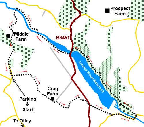
Start:
From the parking (SE 196492), head downhill on Dob Park Road, for only 70
yards or so and turn right to follow a fingerpost for the Six Dales Trail
along a walled track.
%20Start%20of%20walk.jpg)
%20View%20north%20near%20start%20of%20walk.jpg)
Follow the obvious track and as it swings
right at 90°, you get good views towards the reservoir. Almscliff Crag can
be seen on the horizon in the distance.
The track swings left just before a wooded
area and drops down to Crag Farm. At the farm, keep straight ahead along its
access track. Immediately after the track bends left, not far past the farm,
go through the gate on the right hand side (SE
206487).
The footpath passes some trees and after
going through the gate at the end of the field, turn left and a ladder stile
comes into view.
%20View%20across%20Lindley%20Wood%20reservoir.jpg)
Cross the stile and head down the right hand
boundary of the next field, just above a little valley. As the boundary
bends right SE211488), follow it round keeping to the right hand side of the
field.
%20Dam%20at%20Lindley%20Wood%20Reservoir.jpg)
%20Looking%20along%20Lindley%20Wood%20reservoir%20to%20Dob%20Park.jpg)
As the field starts to narrow near its end,
cross the stone step stile by the gate, to the road.
Cross the road and take the footpath opposite
indicated by the old style metal footpath post. A wooden stile with a yellow
arrow indicates the way ahead.
Keep to the right hand side of the next two
fields exiting into the road via a stile (SE
219484). Turn left and follow the road down to the bridge.
Go over the bridge and as it starts to rise,
turn left to follow the fingerpost for Norwood Bottom. The path goes to the
left of the large gateposts.
Follow the obvious path through the woods
alongside the reservoir, until you reach the B6451 road by the bridge. Cross
the bridge and turn right along the waterside indicated by another old stile
footpath post. Just after you turn, there is a bench overlooking the water
for a picnic spot.
%20Washburn%20Valley%20from%20the%20bridge.jpg)
%20B6451%20bridge.jpg)
The path follows the left hand bank of the
River Washburn before crossing a bridge to the other side where you turn
left, to continue following the river.
%20River%20Washburn.jpg)
On reaching a broad track, with a ford
crossing the river, branch left to cross Dob Park packhorse bridge. It is
then simply a case of following the lane, at first a stony track, then
tarmac, back to the car.
%20Dob%20Park%20packhorse%20bridge.jpg)
%20Dob%20park%20bridge.jpg)
%20Lane%20from%20Dob%20Park%20Bridge.jpg)
If you need to buy any
hiking equipment/clothing before your trip see the Hiking
Store
All information on this
site is given in good faith and no liability is accepted in respect of any
damage, loss or injury which might result from acting on it.
|


.jpg)
.jpg)
.jpg)