
|
|
|
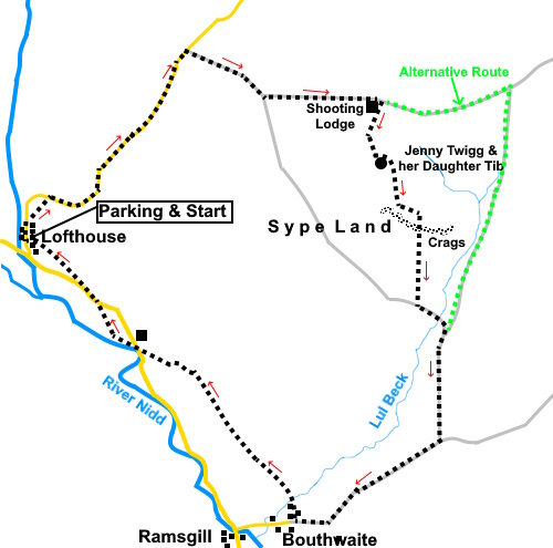
To view route as a dynamic Ordnance Survey map click here. Introduction: This walk from Lofthouse takes you via Jenny Twigg amd
her daughter Tib to Sype Land with its amazing weather eroded rocks. There
are fabulous views over and along Nidderdale. I
planned this walk after spotting the names Jenny Twigg and her daughter Tib
whilst scouring the OS map for a walk which was mainly on tracks and so less
likely to be waterlogged after a very wet winter and indeed heavy rain the
night before. The names aroused my curiosity! The
route involves crossing Access Land and I was unsure how boggy this was
going to be, so, as a backstop, I could have continued on the main tracks as
indicated on the map by the “Alternative Route” in green. However the
Access Land proved remarkably free of bog. The
origins of Lofthouse are probably to house agricultural workers and there
was also some lead mining nearby. Between 1904 and 1908, Bradord Corporation
built a light railway, with a station at Lofthouse to service the
construction of Angram and Scar House Reservoirs along the valley. This
provided a period of prosperity for the village and the Crown Hotel,
formerly a farmhouse, was upgraded to a hotel. The railway also carried
passengers. Unfortunately, once the reservoirs were completed, the railway
was no longer economic and it closed in 1929. In
the second half of the century, the village declined but has had something
of a renaissance with the popularity of tourism and being in an Area of
Outstanding Natural Beauty. Jenny
Twigg and her Daughter Tib are two remarkable weather eroded rocks standing
as sentinels separate from the rest of the rocks on Sype Land. Of course,
they come complete with a legend. A brief version is that a mother and
daughter ran a pub which catered for travelling peddlers. Some of these
peddlers were never seen again and this mother and daughter were becoming
prosperous. You can guess the rest! The pair were thought to be witches who
turned into these stones and have watched over the valley ever since,
perhaps waiting for new victims! Sype
Land has some remarkable weather eroded crags. The photos really tell their
story. As
mentioned above, my route took advantage of the Access land. There are no
footpaths marked and none visible to the crags but as long as you have good
visibility, the direction of travel is pretty obvious. You
will need to climb over two locked gates to get on and off this section.
Please climb the gates at the hinge side where they are strongest. Note dogs
are not allowed because of the risk to nesting birds. You also need to watch
out for them yourself when walking across the heather, though I did not see
either birds or nests. I tried to pick my way across the moor using areas
which were clearer, presumably where heather had been burned but some
trudging across the heather was unavoidable. Precise routes may vary as
different areas grow or are burned. There
will be times when access to this area is not possible because there is
shooting going on. The area is owned by the Swinton Estate and their website
has dates of shoots shown. On those occasions, you will need to stick to the
main public Rights of Way via the alternative route shown but you can still
see Jenny and her daughter, especially if you have binoculars. The walk starts
from the car park at the Memorial Hall in Lofthouse, where my walk to Scar
House Reservoir also starts. To get to Lofthouse, heading west through
Pateley Bridge on the B6265, turn right after crossing the river bridge,
signposted for Ramsgill, Lofthouse and Middlesmoor. Continue along this road
past the expanse of Gouthwaite Reservoir and Ramsgill until you reach a
right turn signposted with a small road sign for Masham 10 miles. It is easy
to miss this turn but some blue warning signs saying Unsuitable for Goods
Vehicles and Buses indicate it. Start: From the car park (SE 101735), turn right up the road,
passing through the village. Just past the national speed limit signs, turn
right to follow a footpath indicated by a fingerpost (SE 102737). This is a
steep path but it cuts off a loop in the road. On meeting the road again, turn right to follow it. The road is steep but there is little traffic and the good news is that once you reach the next instruction, all the climbing for the walk is virtually finished! There are also great views.
Follow the road for just over a mile, until you see a broad track on the right. It has a blue sign warning “Unsuitable for Motor Vehicles” (SE 115751). Follow this track. After about half a mile, it divides. Take the left fork.
Continue to follow the track for another half mile until you reach a shooting lodge on the right (SE 130746). You now need to decide whether to try the Access Land route to see the rocks. Otherwise follow the track for about three quarters of a mile to a junction then turn right to follow another broad track (SE 141748), picking up the rest of my described route at # below.
Assuming you are visiting the rocks, you will need to climb the gate on to the Access Land. You will be able to see Jenny Twigg and her daughter Tib in the near distance. Follow the line of grouse butts and at about the fifth one along, make your way across to them at (SE 130742).
From there, you can see the outliers of the rocks at Sype Land crags (roughly 107 ° magnetic or SE).
You
will reach a wall. There is an easy crossing point where it joins a fence at SE
132740. You will reach the top of the crags. Bear left to follow them.
At some point you will see a huge flat faced rock with its smooth face at about 45° in a southerly direction. About a hundred and fifty yards before this you can find a point to descend to below the crags to join up with a grassy track visible below (SE 134737). There was a sunny spot here against a rock, sheltered from the wind for sandwiches.
Follow
the grassy track down to a gate at SE 133730. Over this, join a broad track
and turn left. Reach a junction with another broad track, after crossing a substantial bridge over Lul Beck and turn right, following it down into the valley. #
After about half a mile, reach a junction with another broad track (SE 135719). Turn right following the fingerpost for “6 Dales Trail”.
After
just short of a mile, you meet a major junction of tracks and road at the
hamlet of Bouthwaite. Turn right following a fingerpost for “Public
Footpath”, “Nidderdale Way” and “Low Sikes 1¼ miles”. Follow
the Nidderdale Way, passing Longside Farm, where it goes through a small
walkers’ gate into the field below. The path through the field is obvious. At
the end of the field the path divides. Keep right. The
next building is Longside House where diverting into the woods would be an
easy mistake. The footpath is actually alongside the fence immediately next
to the property. The
path reaches the road at Low Sikes (SE110726). Cross straight over and
follow the path, initially parallel with the river. After
crossing a stile, the path bears right and there is a barn ahead with a tall
doorway. The onward route is via
a gateway well to the right of this barn, by a small copse of trees. The
path then bears right to join the road via a kissing gate. Turn left along
the road. Just
as you get to the village sign for Lofthouse, turn right along a footpath
indicated by a fingerpost fpr “Lofthouse”. The
car park is now clearly visible ahead. If you need to buy any hiking equipment/clothing before your trip see the Hiking Store All information on this site is given in good faith and no liability is accepted in respect of any damage, loss or injury which might result from acting on it.
| | |||||||||||||||||

.jpg)
.jpg)
.jpg)
%20View%20to%20Gouthwaite%20Reservoir.jpg)
%20Looking%20over%20Lofthouse.jpg)
%20View%20along%20the%20track.jpg)
%20View%20to%20Sype%20Land%20Crags.jpg)
%20Shooting%20Lodge.jpg)
%20Jenny%20Twigg%20and%20her%20daughter%20Tib.jpg)
%20Wind%20eroded%20rocks.jpg)
%20Wind%20eroded%20rocks.jpg)
%20Rocks%20at%20the%20top%20of%20the%20crags.jpg)
%20Flat%20faced%20rock%20referred%20to%20in%20the%20text.jpg)
%20View%20along%20the%20crags.jpg)
%20Looking%20along%20Lul%20Beck.jpg)
%20View%20over%20Nidderdale.jpg)
%20Looking%20up%20Nidderdale.jpg)