|
Lund's
Tower and Cowling Pinacle
|
Starting
point and OS Grid reference:

St
Thomas’s Church, Sutton-in-Craven (SE 007442)
|
Ordnance
Survey Map
OL
21 - South Pennines.
Buy this map from
List
of OS Maps
Note: If you use OS Maps on-line, you can download this route via this
link.
| |
Distance: 7.2
miles
| |
Traffic light rating:

(For explanation see My
Walks page)
| |


For advice on .gpx files see
My
Walks page
|

Click
the PDF logo above to give a printable version of this walk without the
photos.
|
To
view route as a dynamic Ordnance Survey map click here.
Introduction:
This
walk is an easy half day stroll but one which rewards with fabulous views of
the Aire Valley, Simons Seat, Pen-y-Ghent and Pendle Hill to name but a few.
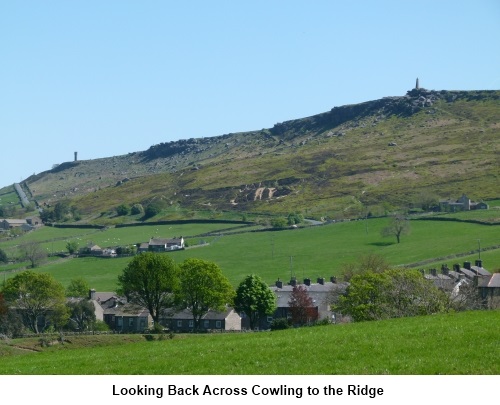
It takes in Lund’s Tower which you can climb to maximise the 360° view.
Lund’s Tower was built by James Lund of Malsis Hall thought to have been
built for his daughter or possibly for Queen Victoria's Jubilee. Cowling
Pinacle which is signposted as such is actually shown on the Ordnance Survey
map as Wainman’s Pinacle. This is a more appropriate name as it was built
by Richard Wainman of Carr Head Hall to commemorate the defeat of Napoleon
in 1815.
Start: The walk starts in Sutton-in-Craven which is
to the west of the B6265 between Keighley and Skipton. There is only street
parking available. For a common point of reference, the walk starts St
Thomas’s Church opposite the park on Main Street (SE 007442). With your
back to the church, turn left and walk to the end of Main Street.
At the end of Main Street, cross straight
over the road and walk down the left hand side of the Black Bull pub along
Ash Grove. Turn right at the end (Bent Lane).
Follow Bent Lane which becomes a farm track. As the tarmac ends, you
can see the castellated tower of Lund’s Tower on the skyline which is your
first goal. As the track forks (the left hand fork going into The Grange)
fork right.
Pass through the hamlet of Bent (SD 996442)
and continue to follow the track as it swings left by a barn. Remain on the
track and cross the
stile you come to at the left of a gate. Walk along the footpath between the
trees and cross another stile. Keep to the right hand side of the field to
the top right hand corner where there is a small gate. Turn right in front
of the cottage (SD 993434).
Follow this track which becomes concrete
after the cobbles and when it forks right to a derelict burned out farm,
fork left. The track exits into a road where you turn left (SD 989432). If
you look behind you at this point, Pendle Hill peeps over the horizon.
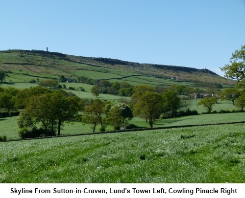
The road climbs and as you pass beneath the
tower, look out for a footpath on the right (SD 992432), indicated by a
finger post indicating Cowling Pinacle half a mile. Some concrete steps climb
up to the tower but if you happen to be looking for a good lunch spot, a few
yards left at the bottom of the steps leads to a couple of picnic tables.
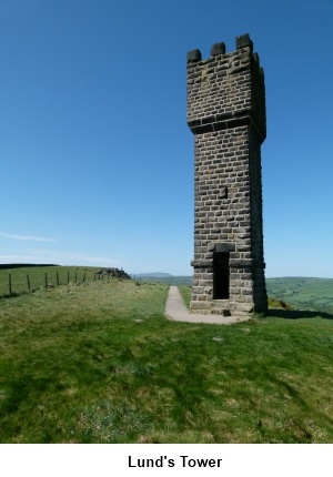
The tower which can be climbed offers a great
vantage point from its top but take great care. It is very dark inside after
the brilliance of the daylight and there is no handrail. The stairs are also
open at the top with no guard rail. There are good views along the ridge to
Cowling Pinacle and Pendle Hill beyond.
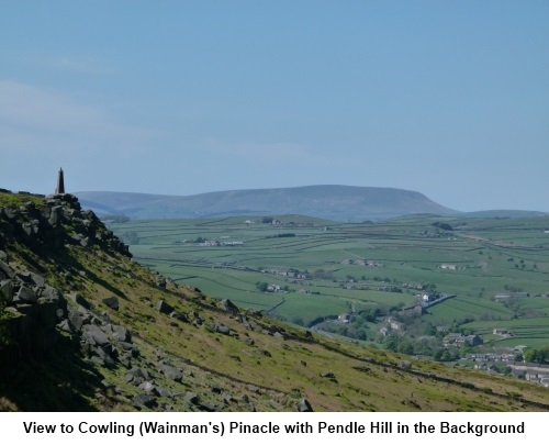
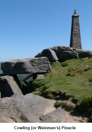
Stay on the main track heading for the
Pinacle (SD 985429) and continue straight ahead beyond it (ignoring the left
turn at the corer of the wall) to the farmhouse at is obviously also a working
stoneyard. Pass to the right of the buildings. Head across the field
beyond and through the kissing gate. The path descends a small hill and at a
stone wall, go left through a small gate and immediately right through a
narrow stile.
Once through the stile descend to a track and
turn right (SD 975427). It looks as though there was a sunken lane at this
point but it is now impassable. The path skirts round this over a raised
hump in the ground.
After passing an old concrete water tank now
housing a green plastic one, walk down to the cottages going between them to
the lane (Fold Lane). The cottage to the left has a Victorian stile
lamppost.
At the main road, turn left. As you leave the
village, turn right down Winkholme Lane (leading to Gill Lane) (SD 970431).
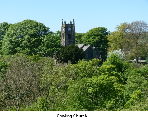
Walk down through the hamlet, over the river
bridge and up the other side. As you get to the church turn right through
the little gateway to the right of the churchyard (SD 968431) and follow the
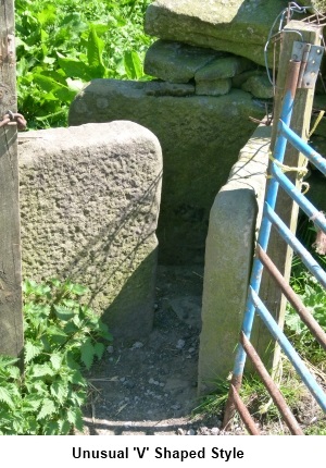
broad bridle path past the radio mast. As you pass a barn, look out for the
unusual ‘V’ shaped stile to the right of a gate ahead of you and follow
the path through it.
The route now becomes a narrower footpath
following the course of the river below. At a fork, go left passing a bench
dedicated to a Brian Garside (“A very special man!”).
Turn
left over a new bridge painted green then immediately right to follow the
stream. The area here can get quite well visited and what look like paths
get trampled all over. The best advice is to follow the course of the river
until you reach some stone steps to the right going to the river. Bear left
here away from the river (although if you want a restful sit next to the
river, if you descend the stone steps, there is a bench by the water).
The path exits through a small stone stile
into the road (SD 981445). Turn right and after a few yards, look out for a
finger post on the left. Go
through a narrow stile and descend
the field to the road below.
Turn left at the road, cross over a brook
then turn right where a finger post indicates the path (SD 982445). Cross a
stone step stile then after
going through a squeeze stile and crossing a footbridge, the stile in the
next field is difficult to spot. It is in the far left hand corner under the
trees.
After the next two gates, the footpath opens
into a farm lane. Turn right. Continue on this lane past Scott House Farm
before turning right on to a footpath marked with a yellow arrow immediately
past the gate to Green House Farm (SD 995450). The footpath has been
diverted and circles around the farm going through another gate. Walk down
the next field and after passing through two gates, go under the arch
between the houses.
Turn left after the arch and walk through to
the main road and turn right. Immediately after crossing the river (SD
995446) (and this means immediately!), cross the road and go through a small
gate by the left hand cottage.
At first glance, it looks like a gate into the property but there is a
finger post which is easy to miss.
The path initially follows the river. Until
at a newish gateway, it swings to the right. Through a kissing gate, stick
to the path on the right and look out for a stile on the right to some stone
steps. This is your route heading away from the river. Cross a field and
pass between two houses into a suburban street (Hazel grove). Turn right and
continue to Bent Lane (which was on your outward route). Turn left and left
again on Ash Grove back to your start point.
If
you need to buy any hiking equipment/clothing before your trip see the Hiking
Store
All information on this
site is given in good faith and no liability is accepted in respect of any
damage, loss or injury which might result from acting on it.
|


.jpg)
.jpg)
.jpg)