
|
|
|
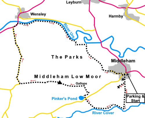
To view route as a dynamic Ordnance Survey map click here. Introduction: This is a lovely walk from Middleham in Wensleydale. It crosses Middleham Moor which is Access Land so you are free to wander at will. The views of Wensleydale from the summit are beautiful. I have walked sections of this walk before, notably in my Middleham to East Witton and Harmby to Middleham walks. Middleham is the centre of racehorse country and there are ‘gallops’ across the moor fenced in with white rails. It is obviously unwise to walk within the fencing as you would not be wise to be in the way of racehorses travelling at potentially 30/40 mph! In any case, the soft nature of the surface of the gallops will make for hard walking! However if you are lucky enough to see them in action, it is an impressive sight. Middleham is famous for its massive 12th Century castle, the childhood home of Richard III. It is greatly out of proportion to the relatively small village. It is in the care of English Heritage. The village has an attractive cobbled centre and Georgian houses and cars can be parked free in the market square and on the main street. Public toilets and a selection of cafes/pubs are available both at Middleham. On the outskirts of the village is Williams Hill, the remains of an 11th Century motte and bailey, a predecessor to the main castle. Its ditchwork is clearly visible. The route passes Pinker’s Pond, a tarn created in the 1900s as part of the work to construct the road. It is popular for bird watching. It is named after a racehorse of the same name which won its first race at Catterick Bridge in 1962. Wensley is a small, pretty village from which the dale gets its name, unlike other dales which take their names from the rivers which run through them. In this dale, the river is the Ure. Wensley received its market charter in 1202 and held the only market at that time. It boasts a fine pub, the Three Horseshoes and the White Rose Candle Workshop where as well as buying candles, you can watch them being made. The walk starts from the cobbled market square in Middleham. To get there, take the A6108 from either Leyburn to the west or Ripon to the east and follow the signs. Start: From the market square, walk uphill along the main street (Coverham Lane) and look out on the left for an old, narrow, cobbled lane on the left alongside the Castle Keep Tea Rooms and turn up here. This takes you past the entrance to the magnificent Middleham Castle which if you can spare the time is well worth a look round.
Continue past the castle and look out for a walkers' gate on the right from which a footpath runs to the obvious Williams Hill. It is worth climbing this for the view, not least over Middleham Castle. Note the easiest way to climb Williams Hill is to head to the right as you get to it and you will see a well trodden path to the top.
Return to the main footpath and continue along it to just above the river at a ‘T’ junction of paths, crossing a ‘gallop’ on the way. Turn right at the ‘T’ junction (SE 127865). Keep following the obvious path, passing pretty Hullo Bridge (SE 118865), which you do not need to cross other than to take a photo! Shortly after the bridge, the path curves right.
The path arrives at a road by Pinker’s Pond (SE 114869). Cross straight over the road, climbing to the right of the pond.
Just past the pond, the route curves right just in front of an old quarry. Reach a broad track. I turned left briefly and then headed north across Middleham Moor to the white rail of the ‘gallops’, clearly visible. Turn left to follow the rail. This is the best way of ensuring you do not miss the trig. point at (SE 105874).
From the trig point, the route bears gently right towards a copse of trees, passing the end of a row of white railings.
You will
reach a broad track of similar material to the ‘gallops’, obviously an
access for the horses. Follow it along ensuring you do not get in the way of
any of them! It is easier to walk on the grass in some places anyway. At the road (SE 092874), turn right and follow in downhill to Wensley. Turn right just before the bridge to follow the southern bank of the river. To see the village first or visit the pub, cross the river bridge.
The path follows the river closely for just under a mile and a half. It then turns directly away from the river (south) at a grey gate/fence for about two hundred yards, as the river bends north. It then turns left along a broad track. The next section is quite difficult to describe but I will do my best. The paths are quite well walked so in all probability, the route will be clear on the ground. Look out for a metal walkers’ gate on the right and immediately after it, turn right up a footpath. Almost immediately, go through another walkers’ gate and turn left to follow a field boundary for a few yards before striking out left across the field. At the time of my walk, there was a tree in the centre of the field (which I obviously cannot be sure will remain indefinitely) but you need to be to its left. In the fence line beyond the tree, look for a gateway. Go through the copse of trees beyond and through another gate, bearing slightly left to follow a blue bridleway arrow. Follow the left hand field boundary until the boundary ends at a stretch of grass. Cross it to a gate and follow the obvious path beyond there. About three quarters of the way across the field, the path curves left to a gate (SE 118882). Through this gate you can take either path into the village. I opted for the right hand path climbing slightly, to the diagonally opposite corner of the field. Join the
broad access track to a house and turn left. Join a tarmac lane and turn left back into Middleham.
If you need to buy any hiking equipment/clothing before your trip see the Hiking Store All information on this site is given in good faith and no liability is accepted in respect of any damage, loss or injury which might result from acting on it.
| | |||||||||||||||||

.jpg)
.jpg)
.jpg)
%20Market%20Square%20and%20Market%20Cross,%20Middleham.jpg)
%20Cobbles%20lane%20to%20the%20castle.jpg)
%20Williams%20Hill.jpg)
%20Earthworks%20on%20Williams%20Hill.jpg)
%20Middleham%20Castle.jpg)
%20View%20to%20Pen%20Hill.jpg)
%20Hullo%20Bridge.jpg)
%20River%20Cover%20from%20Hullo%20bridge.jpg)
%20Pinkers%20Pond.jpg)
%20View%20to%20Braithwaite%20Moor.jpg)
%20Looking%20along%20the%20gallops.jpg)
%20Trig%20point%20on%20Leyburn%20Moor.jpg)
%20Looking%20up%20Wensleydale%20to%20The%20Mount.jpg)
%20The%20Mount%20Tower.jpg)
%20Pretty%20cottages%20in%20Wensley.jpg)
%20Holy%20Trinity%20Church%20Wensley.jpg)
%20Wensley%20Bridge.jpg)
%20Old%20School%20Middleham.jpg)