|
South
Stainley Circular
|
Starting
point and OS Grid reference:

South
Stainley – Church car park – honesty box
(SE 306632)
|
Ordnance
Survey Map
OS
Explorer 299 – Ripon & Boroughbridge.
Buy this map from
List
of OS Maps
Note: If you use OS Maps on-line, you can download this route via this
link.
| |
Distance: 6.3 miles
| |
Traffic light rating:
  
(For explanation see My
Walks page)
| |


For advice on .gpx files see
My
Walks page
|

Click
the PDF logo above to give a printable version of this walk without the
photos.
|

To
view route as a dynamic Ordnance Survey map click here.
Introduction:
This is an easy
walk, almost entirely along well defined tracks. It is ideal for the
short winter days. There are good views across to the North York Moors,
including the Kilburn White Horse and to the west on the homeward section.
The walk takes in the attractive villages of
Copgrove, Burton Leonard and South Stainley itself, with their equally
attractive churches. Burton Leonard especially is very picturesque with its
village green areas and the opportunity for refreshment at the Royal Oak. – check opening times.
St Michael and All Saints church at Copgrove
has a useful seat for a picnic lunch and there is another bench in the
village on a grassy area on Mongahs Lane in Copgrove.
The walk starts from the church car park at
South Stainley. This parking is available for public use except before
11.00am on a Sunday. There is an honesty box and I urge anyone using the car
park to make a donation to encourage retention of the facility. To get to
the car park, turn east off the A61 at South Stainley, about 5½ miles north
of the centre of Harrogate. The junction is not signposted. You need to turn
down the right hand side of the The Inn. Follow the road through the
village and the car park is opposite the church.
Start:
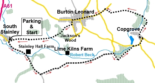
From the car park (SE 306632), facing the church, turn right to walk along
the broad tarmac track, in the direction of the “Public Bridleway”
fingerpost. You immediately pass a sign to show you are entering Mountgarret
Estates land.
%20St%20Wilfred's%20Church%20South%20Stainley.jpg)
When the track splits, the left hand arm
indicated as a private road to Stainley Hall Farmhouse, turn right over the
bridge. Stay on the main track, passing the old drive to Stainley Hall
Farmhouse which goes through two significant gateposts in the field to your
left.
%20Stainley%20hall%20farmhouse.jpg)
Go through a gate, ignoring the right turn
(SE 313626). The track climbs very gently through the woods. You soon leave
the trees to walk between open fields. At a ‘T’ junction, where there is
an old stone milepost, turn left to follow the blue bridleway arrow (SE
316622). This track is shown as Raikes Lane on the OS map.
%20old%20Milepost%20at%20Raikes%20Lane.jpg)
%20Autumn%20in%20Raikes%20Lane.jpg)
Pass the end of a lane with a cattle grid (SE
323625), descending to farm buildings with red tiled roofs (Limekiln Lane on
the OS map). Although a sign indicates the public bridleway heads down here,
ignore this and keep straight ahead. You soon go over another cattle grid
where there is another “Public Bridleway” fingerpost. Follow its
direction straight ahead.
The track crosses open fields and you will
see Robert Beck to the left.
After passing a steel barrier, the track
becomes hedged and you are following the course of two sets of powerlines.
After a few hundred yards, the track curves right leaving the power lines
behind.
Pass under another two sets of powerlines,
before descending to a wooded area. You arrive at a ‘T’ junction in the
trees next to a ford with concrete over wide pipes (SE 3376628). Turn right
here, following the old style metal public bridleway sign.
The track climbs gently past a wood on the
left. At the end of the wood, after passing under powerlines again, turn
left off what is now a tarmac track, through a gate to walk alongside
another side of the same woods (SE 338626). The gate is not marked but it is
the only one so easy to spot. The track passes between hedgerows.
Follow this track to the road where you turn
right into Copgrove (SE 343630). Before continuing however, it is worth
turning left for 50 yards or so to the bridge, for a look along the length
of the lake in front of the Hall.
%20Lake%20at%20Copgrove.jpg)
Follow the road into Copgrove. There can be
quite a bit of traffic on this stretch, including some heavy lorries.
However, there are wide verges to keep you out of harms way and you are only
on it for ¼ mile. Stay on the main road as you pass the old gatehouse,
following the road sign for “Stavely 1½ Boroughbridge
5 miles”.
When the main road bends right (SE 346633),
turn left along Mongahs Lane. Before doing so however, you might like to
view St Michael and All Angels church on the corner or avail yourself of the
bench in the churchyard for your picnic. Alternatively you will soon pass
another bench on a grassy area on Mongahs Lane.
%20St%20Michael%20and%20All%20Saints%20church%20Copgrove.jpg)
Follow Mongahs Lane and not far past the
bench, turn left, then almost immediately right by the electricity
transformer, to follow the footpath between the houses. As the track bends
left, go straight ahead to follow the yellow footpath arrow to the left of
Newholme Cottage. Cross a stile into a field and keep straight ahead as the
field descends to trees, where the route goes anti-clockwise around the
right hand end of them.
By the trees, cross a stile on to a broad
track and turn left.
As the track bends right to barns, go over
the stile straight ahead on the bend and walk down the right hand side of
the stream a few yards to a footbridge (SE 346639). Cross this and keep
straight ahead to follow the broad track, rising slightly to the right of
the woods.
Follow the track as it curves to the right
and it is along this section, as the land drops away to the right where
there are good views across to the North York Moors. If the weather is clear
you should be able to make out the White Horse at Kilburn.
%20View%20towards%20the%20NY%20Moors.jpg)
%20NY%20Moors%20and%20White%20Horse.jpg)
Cross a cattle grid (or use the stile)
keeping straight ahead and ignoring the footpath off to the right. Also
ignore a track off to the left on a right hand bend.
At the road (SE 335641), turn left and go
straight over at the crossroads into Burton Leonard, along Mill Lane.
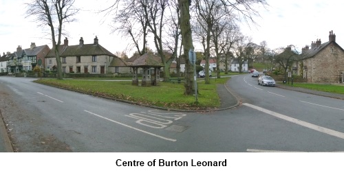
Pass St Leonard’s
Church, the village green with its shelter and village pump and climb the
slight hill. On the green to the left are a couple of large trees with
circular seats around them. Turn left along Scarah Lane. Look out for white
painted Prospect House on the left and opposite this, turn right following
the “Public Footpath” fingerpost (SE 325637).
%20St%20Leonard's%20Church.jpg)

%20Burton%20Leonard.jpg)
As the field descends, there are good views
to the south-west.
%20View%20SW%20from%20Nr%20Burton%20Leonard.jpg)
The path passes through Jackson’s Wood.
When the track curves left and a sign indicates no public right of way, turn
right on the bend to follow the public footpath arrow. The path opens into a
field. Head for the diagonally opposite corner.
%20Track%20Through%20Jackson's%20Wood.jpg)
At the corner, go through the gap in the
hedge and bear round to the right on a broad track. Follow the track as it
meanders through the fields. After crossing a level field, along its right
hand boundary, the track turns sharp left and there is again a sign
indicating no right of way. Go straight ahead (i.e. do not go round the
bend) heading towards some woods. The path goes over a stile at the right
hand end of the woods, and follows the edge of them. At the next corner of
the woods, go over another stile and follow the right hand field boundary.
You come in sight of South Stainley Church.
Follow the left hand boundary wall of the churchyard back to the car park.
If you need to buy any
hiking equipment/clothing before your trip see the Hiking
Store
All information on this
site is given in good faith and no liability is accepted in respect of any
damage, loss or injury which might result from acting on it.
|
