|
Thruscross
Reservoir Walk
|
Starting
point and OS Grid reference:

Free Yorkshire Water car park on Reservoir Road (SE 154574).
|
Ordnance
Survey Map
OS
Explorer 297 – Lower Wharfedale and Washburn Valley.
Buy this map from
List
of OS Maps
Note: If you use OS Maps on-line, you can download this route via this
link.
| |
Distance: 4.8 miles
| |
Traffic light rating:


(For explanation see My
Walks page)
| |


For advice on .gpx files see
My
Walks page
|

Click
the PDF logo above to give a printable version of this walk without the
photos.
|
To
view route as a dynamic Ordnance Survey map click here.
Introduction:
Thruscross Reservoir is the last of
four reservoirs, as you head north up the Washburn Valley, in the Nidderdale
Area of Outstanding Natural Beauty. The others are Fewston, Swinsty and
Lindley Wood. Whereas the latter stem from Victorian times, Thruscross was
constructed in the 1960s and was completed in 1966. Flooding of the valley
meant the loss of West End village, which disappeared beneath the waters.
Sometimes, when there is a very severe drought, the water level drops
sufficiently to expose the remains of the village and its stone bridge.
Personally, I think it would have been more appropriate to name it West End
Reservoir, to commemorate the village it destroyed.
The dam is an impressive structure, albeit
concrete rather than the more attractive stone of other reservoirs.
The shape of Thruscross Reservoir makes it a
bit more interesting than some reservoirs and it is quite a demanding walk
in places, due to ups and downs in the trees. Wayfinding in the trees can
also be tricky and also because when the bracken is at its most rampant in
summer, sections of the path to the NE of the reservoir can be difficult to
spot, to say the least. The steep parts tend to be short but numerous so I
have erred on the side of an amber traffic light, rather than lull anyone
into thinking this walk is a piece of cake!
Much of the route is a concessionary one made
available by Yorkshire Water, so it does not all appear as a Right of Way on
an OS map. Although black arrows mark some of the route, they are small and
difficult to spot in places.
I have included GPS information but a GPS
receiver is mostly useless because the paths are either amongst conifer
trees, where there is no signal, or are so clear by the water’s edge, as
to render one unnecessary. One may help amongst the bracken.
Even after a dry spell, there are likely to
be muddy sections so I recommend boots and gaiters.
The walk starts from the car park provided by
Yorkshire Water (SE 154574). To get there, turn north off the A59 at
Blubberhouses, between Harrogate and Skipton, signposted to West End 2½
miles. After 1.8 miles, turn right on to Reservoir Road, which is signposted
for Dacre 4 miles, Greenhow Hill 6 miles and Pateley Bridge 9 miles.
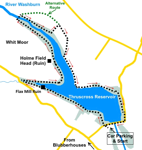
Start:
Leave the car park (SE 154574) by the main entrance and across the lane. Go
through the gateway at the other side and walk down the path through the
trees. At the water’s edge, the path bears left, going clockwise around
the reservoir. You will pass the ruin of an old flax mill by the water’s
edge.
%20View%20over%20Thruscross%20Reservoir.jpg)
%20View%20towards%20northern%20arm%20of%20reservoir.jpg)
%20Waterside%20Path.jpg)
%20Flax%20mill%20remains.jpg)
Follow the path to a narrow stile which exits
into the lane. However, do not go through this but take the narrow path to
the right which descends to a small footbridge over Capelshaw Beck (SE
140582). Cross this and turn right. There are a couple of paths here but
take the one furthest right.
%20Footbridge%20over%20Capelshaw%20Beck.jpg)
At a ‘T’ junction of paths, turn right
again.
After passing a ruined farmhouse, Holme Field
Head, on your left, come to a junction of footpaths. Keep right following
the black arrow.
%20Ruin%20of%20Holme%20Field%20Head%20Farmhouse.jpg)
%20River%20Washburn.jpg)
Through the trees, finding the correct path
can be a bit tricky but eventually, you drop down to follow the river
Washburn. Turn left to follow the path alongside it, to a bridge (SE
139593). This bridge is one of the ugliest I have ever seen. It looks to
have started life as a couple of stone pillars with a surface supported by a
couple of steel girders. However at some point the Health and Safety police
must have decreed that handrails should be fitted, so these look to have
been have been added as a separate structure, using a bracing principle. The
net effect is a jumble of scaffolding. It is safe and serves the purpose but
my goodness, it is ugly! I digress.
Cross the bridge, where you will find a stile
“crossroads”. Here you have the choice of taking the path up to the
rocky outcrop ahead where you turn right to follow the path along the ridge
(see alternative route on sketch map). However I turned right to follow the
path through the trees. With hindsight, I wished I had taken the path to the
rocks as this next section is very muddy in places and wayfinding is not so
easy; but I like a challenge!
%20Rocky%20outcrop%20at%20Roundells%20Allotment.jpg)
Eventually, the path climbs a steep section
emerging above the trees (SE 145591). Do
not make the mistake I initially made of turning immediately right to
follow what seems to be a path along the fence line but go straight ahead to
the top of the low ridge and pick up the path (SE 146592), which comes from
the rocky outcrop mentioned above, and turn right (SE). Finding this path,
as I found, can be tricky when the bracken is at its height.
Follow the path along the ridge. It turns
right at a marker post (SE 147589) and drops down to a ladder stile. Cross
this and follow the path along by the reservoir. At this point, the path is
surfaced with large stones.
%20Waterside%20Path%20on%20return%20leg.jpg)
The path eventually starts to run parallel
with the road before exiting into it (SE 157576). Turn right to cross the
reservoir dam via the road and look out for the car park where you started,
on the left.
%20Looking%20along%20the%20reservoir%20from%20the%20dam.jpg)
%20Thruscross%20Reservoir%20dam.jpg)
If you need to buy any
hiking equipment/clothing before your trip see the Hiking
Store
All information on this
site is given in good faith and no liability is accepted in respect of any
damage, loss or injury which might result from acting on it.
|


.jpg)
.jpg)
.jpg)