|
Washburn
Valley and the Three Reservoirs Walk
|
Starting
point and OS Grid reference:

Car park at Swinsty Reservoir (SE 199538)
|
Ordnance
Survey Map
OS Explorer Map 297 - Lower
Wharfedale & Washburn Valley.
Buy this map from
List
of OS Maps
Note: If you use OS Maps on-line, you can download this route via this
link
| |
Distance: 8.5 miles
| |
Traffic light rating:

(For explanation see My
Walks page)
| |


For advice on .gpx files see
My
Walks page
|

Click
the PDF logo above to give a printable version of this walk without the
photos.
|
To
view route as a dynamic Ordnance Survey map click here.
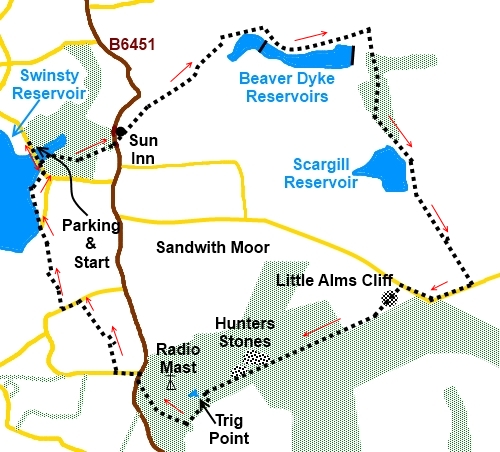
Introduction: There
are a multitude of walks in the Washburn Valley itself. This walk from
Swinsty Reservoir starts in the valley but climbs very gently away from it
to include Beaver Dyke and Scargill reservoirs, Little Alms Cliff (no doubt
named because of its resemblance to the better know Almscliffe Crag) and
Hunters Stones.
The walk goes
through Haverah Park, formerly
one of the royal parks of the Forest of Knaresborough created about
1117 and you can still see deer if you are lucky.
This is a very easy
walk of water (reservoirs and babbling brooks) and forests and for little
effort provides lovely far ranging views.
Please note that
after rain, the route can be very muddy in parts.
There are no
refreshment opportunities en route other than what you bring yourself. There
are a couple of good spots to enjoy your sandwiches mentioned below.
Afterwards, the Sun
Inn at Norwood is close by and open all day.
The walk starts
from the car park at Swinsty Reservoir. To get there, turn west off the
B6451 between the A59 and Otley, signposted Fewston. The car park is on the
left after crossing the causeway across the reservoir.
Start: Leave the car park (SE 199538) and
walk back across the causeway. Turn left on to the public footpath with the
fingerpost for “Dalesway Link” and “Brame lane” (SE 200536). Be sure
to bear right here and follow the yellow arrow.
%20view%20over%20swinsty%20reservoir.jpg)
Follow the path as
it wends its way through the trees. There are dilapidated walls at both
sides. When the walls start to diverge and the path appears to fork, follow
the path on the left which, for a while, follows the left hand wall.
At the edge of the
woods, go through a walkers’ gate where the path bears off very slightly
to the left. Go over a stile and follow the left hand boundary of the field
and through a gateway to the road (SE207538).
Turn left along the
road for a few yards and at the Sun Inn (to its right) turn right following
the fingerpost for “Dalesway Link” and “Bank Slack ¾ mile”. The
path passes the front door of the pub and through a gap in the wall passing
a barn conversion named Twin Paddock Barn.
Follow the drive
and as it swings right (SE 212543), bear left across the grass following the
public footpath fingerpost to a kissing gate in the bottom left hand corner.
From here, the path bears slightly left across the next field to another
kissing gate which you should be able to see. Through this and follow the
direction of the arrow straight ahead.
Go through another
gate and the route goes round the bottom of a banking on top of which sits
Bank End Farm. You reach a dilapidated wall but do not make the mistake of
climbing the banking here. Follow the right of the dilapidated wall until
you reach a walkers’ gate with yellow arrows. You cannot easily see the
gate until you are almost at it.
Through this gate
and the path does then climb the banking to a gate where another yellow
arrow directs you along the left hand edge of the trees.
You come in sight
of the first reservoir (Beaver Dyke – actually two reservoirs together)
and the windmills. The path passes the left of the reservoir on top of a
banking for a while, before descending right, to the wall.
%20beaver%20dyke%20reservoir%20and%20wind%20turbines.jpg)
Follow the course
of the wall for a short distance and as you get to an old gateway, the path
veers round to the left as indicated by the arrows. After quickly going
through another gateway and a short section of walled track, turn right at a
gatepost, indicated by yellow arrows.
Follow the obvious
path along passing a ruined barn. There are a couple of useful seats here on
which to enjoy your sandwiches with a fine view of the reservoir.
Eventually, the
path drops down to the wall alongside the reservoir and follows it along to
the dam.
Continue straight
ahead at the dam (do not cross it). You soon come to a gate from where the
path goes left through the trees. When you come out on a farm track just
above another dam, go straight ahead on this, passing several farm buildings
and under some power lines.
Immediately after
passing under the power lines, turn right through a gate (SE
230548) and follow the right hand boundary of the field. At the bottom, a
yellow arrow on the gate confirms the route.
Turn left when
reaching the reservoir service road (SE 231546).
You now follow this
service road for 1½ miles passing through Low Scargill Plantation (where I
have seen deer), past and Scargill Reservoir with its ornate bridge across
the spillway. As the road climbs, there are good views left, across to the
North Yorkshire Moors.
%20scargill%20reservoir%20spillway%20and%20bridge.jpg)
As you pass a
barrier across the service road, there are some rocks off to the left which
provide another good lunch stop with good views over the Washburn Valley and
to the Menwith Hill radar domes to the north.
%20menwith%20hill.jpg)
When the service
road reaches the “proper” road (SE 240524), turn right and walk along
the road (there are wide verges), past the car park for just under ½ mile
and look out on the left for the unmistakable rocky outcrop of Little Alms
Cliff. Turn left off the road at a small rough lay-by (SE 234524)and take
the path to and over the top of the outcrop. There are great views from the
top.
%20little%20alms%20cliff%20from%20the%20road.jpg)
%20little%20alms%20cliff.jpg)
Over the top and
the path becomes indistinct. The path splits into two and you want to head
left towards where the trees form a right angle (heading left of the tower).
There is a stile at the corner but you cannot see it until you are almost
there (SE
228520).
Over the stile and
the path follows the course of the fire break between the trees, alongside a
dilapidated wall. This section can be particularly muddy.
You come to an area
of large rocks, Hunters Stones (SE 218516).
%20approaching%20hunters%20stones.jpg)
%20hunters%20stones.jpg)
From Hunters
Stones, you need to be careful to take the correct route as the jumble of
rocks, tracks and trees can be quite confusing. The actual path is straight
on from the route you followed along the fire break. Keep to the left of the
stones (preferably use a compass to ensure you leave the stones at 245°
(Trees make a GPS receiver unreliable). After crossing a broad
track/firebreak, take the path ahead through the trees and you should arrive
at a stone wall more or less opposite a trig. point perched on a rock in the
field beyond – see photo.
%20trig%20point.JPG)
[If you go wrong and
come to the corner of two walls with the radio mast in front of you. Turn
left to follow the walk along the edge of the trees (no footpath – you
have to make your own way). Eventually the trig. point mentioned above comes
into view and when you reach a track from the left, you are back on course
as at # below.]
The radio mast is a
useful reference point (whenever
you can see it through the trees) as it should always be to your right. In
effect, whichever of the routes you pick below, you are effectively walking
clockwise round it.
# Turn left here and follow the wall.
At an old narrow gateway, go through the wall on the right and turn left.
There are great views across Wharfedale here. Follow the path down to a wide
track (SE 215514).
%20view%20over%20wharfedale.jpg)
I followed the
course of official footpaths here but I believe that if you turned right on
this wide track then, at the next ‘T’ junction of tracks, turned left,
then right at another ‘T’ junction, you would reach the B6451 as below.
Try it if you like. Otherwise, continue as in the next paragraph.
To follow the
“official” footpaths, on reaching the wide track, across the track and
very slightly to the left, another footpath descends the slope alongside the
wall. Follow this to a stile on the right (SE 215513). Cross this then go
across the field to the bottom of the tress at the opposite side where there
is a gate (SE 213511). Through the gate then go right at about 45° and
follow the track through the trees.
Follow this track
to join the main road – the B6451 at a rough parking area (SE
209515). Turn right here for a few yards then cross the road to turn left
along a minor road (marked as Top Lane on the OS map). Be
very careful crossing the B6451 as there is a blind summit to the left and
it is a very fast road.
Take the first
turning on the right following the finger post for “Brat Lane ½ mile” (SE
207516). As you arrive at the gateposts to the property, turn right through
the walkers’ gate and walk round the back of the property. At its rear,
turn right through another walkers’ gate heading downhill towards Swinsty
Reservoir.
%20washburn%20valley%20reservoirs.jpg)
On reaching the
road (Brat Lane), turn left then first right to Scow hall Farm (SE
202522). There is a public bridleway fingerpost. Go straight through the
farmyard following the track as it curves left.
You get to three
gates. Go through the one on the left. Follow the track downhill and as it
turns left, go right through a red gate. There is a blue arrow on a post
indicating the direction. The path is now walled.
Follow this path
down through another red gate until you reach a main reservoir road. Cross
this slightly left through some iron gates and follow the path round the
reservoir back to the car park.
If you need to buy any
hiking equipment/clothing before your trip see the Hiking
Store
All information on this
site is given in good faith and no liability is accepted in respect of any
damage, loss or injury which might result from acting on it.
|


.jpg)
.jpg)
.jpg)