|
Dovedale
and Tissington
Starting point and OS Grid reference:

Thorpe
village – free car park at Narlows Lane (SK
164505)
|
Ordnance Survey Map
OL24
– The White Peak area.
Buy this map from
List
of OS Maps
Note: If you use OS Maps on-line, you can download this route via this
link.
| |
Distance: 7.8 miles
|
Date of Walk: 20
April 2015
| |
Ascent:
Descent:
See Walking Time Calculator
|
1553 ft (473m)
1555 ft (474m)
| |
Traffic
light rating:


(For explanation see My
Walks page)
| |


For advice on .gpx files see
My Walks page
|

Click
the PDF logo above to give a printable version of this walk without the
photos.
|
To
view route as a dynamic Ordnance Survey map click here.
Introduction:
A Dovedale walk is virtually an
obligatory outing for anyone who has ever walked in the Peak District.
Hardly surprising as it is a dramatic limestone gorge, a beauty spot with
few equals. Many start it from the village of Milldale and treat it as a
linear “there and back” stroll. However this route creates a circular
walk also taking in the beautiful village of Tissington and a section of the
Tissington Trail.
Dovedale is very popular and there is no
chance that you will have it to yourself but the attractive scenery makes it
worthwhile. However, I would avoid peak periods (no pun intended!) if
possible
It is an easy walk with a slight climb out of
Dovedale at Hall Dale.
The melting water from the Ice Ages created
Dovedale and caves which have been used by ancient man for a variety of
purposes.
The River Dove is well known to trout
fishermen and made famous by Izaak Walton's The
Compleat Angler. It forms the boundary between Derbyshire and
Staffordshire.
There are a number of interesting rock
features, not least Ilam Rock (technically in Staffordshire), Dove Holes
(caves) and Tissington Spires.
There are masses of blackthorn bushes so if
you like sloe gin, autumn would be a good time to do the walk!
Tissington village is a beautiful unspoiled
spot and has been controlled by the FitzHerbert family since the reign of
Elizabeth I. The family live in a Jacobean Manor in the village centre,
built in 1609. The village is perhaps best known as the home of well
dressing which attracts huge crowds when the 5 wells are dressed with
boards, decorated with flower petals, on Ascension Day. Unfortunately, it
lacks a pub! However there is a tea room.
The Tissington Trail runs for 13 miles from
Ashbourne to Parsley Hay, following the course of the Buxton to Ashbourne
railway line, which closed in the 1960s. This route just follows one and a
half miles of it. It is very popular with cyclists, some of whom do not seem
to have the “nous” to warn you of their approach so take care.
Refreshments are available at Tissington
which is quite near to the end of the walk. Otherwise it is a picnic. There
are toilets also at Tissington.
The walk starts from free parking at Narlows
Lane car park at the village of Thorpe (where there is a pub!). To get
there, turn west off the A515 (opposite the main turn to Tissington), signed
for Thorpe and Ilam. The car park is on the right, just on entering the
village.
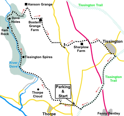
Start:
Turn right out of the car park (SK 164505). At the road junction, go
straight ahead following the road sign for “Thorpe Dovedale and Ilam”.
Walk along the road for a quarter of a mile
and at the entrance to the hotel, The Peveril of the Peak, turn right
through a squeeze stile, following the public footpath fingerpost and yellow
arrow for the Limestone Way (SK 159505).
The route is obvious and at the second stile,
a National Trust sign indicates you are entering Thorpe Pastures. Turn left
here to follow the public footpath fingerpost
for “Dovedale ¾ mile”. Note the signs for the firing range on
the right which will soon provide a useful guide for the route.
Follow the footpath behind the hotel and when
the wall on the left turns sharp left, turn right at about 45° to the wall.
Heading to the right of Thorpe Cloud (the hill with its distinctive conical
shape) and staring to descend down Lin Dale. The path is well walked and
obvious. If in any doubt, follow the line of the firing range signs.
%20Thorpe%20Cloud.jpg)
The path drops down to meet a broad path in
the valley bottom (SK 152514). Turn right to follow the course of the river
Dove, along the right hand river bank, the direction of the public footpath
fingerpost to Milldale 2½ miles.
%20Stepping%20stones%20in%20Dovedale.jpg)
%20View%20with%20blackthorn.jpg)
%20River%20Dove.jpg)
The path climbs some steps at SK 146518
before descending again.
You pass the rocky bluffs of Tissington
Spires (right), Ilam Rock (left) and the double caves of Dove Holes.
%20Tissington%20Spires.jpg)
%20Ilam%20Rock.jpg)
At SK 142531 come to a footbridge between two
pinnacles of rock but do not cross it Continue along the riverbank following
the fingerpost for Milldale 1¼ miles.
%20Dove%20holes.jpg)
At SK 142536, pass the two caves of Dove
Holes and shortly after this, turn right to follow the public footpath sign
for Alsop-en-le-Dale 1¾ miles. The path climbs quite steeply through the
woods (hence the amber traffic light), before leaving them via a walkers’
gate. Keep straight ahead to a three way fingerpost which you can see.
At the fingerpost, join a broad access track
to the farm. Turn right following the fingerpost for Tissington. You need to
concentrate now. As the farm track swings right, leave it and continue
straight ahead, to the corner of the walls just to the right of the copse of
trees (SK 150534). Here is a fingerpost for Tissington (rather dilapidated
when I did this walk). Follow it over a stone stile, alongside the left and
field boundary, until you reach a stone step stile. Cross this to follow the
public footpath fingerpost. There are good views here back over Dovedale.
%20Looking%20back%20over%20Dovedale.jpg)
Follow the right hand boundary of the field
and after passing a copse of trees, arrive at Bostern Grange Farm. Turn
right through the farmyard (SK 153534), following a clear track. At a
gateway, there is a stone step stile to the left. From here head slightly
left to stay parallel with the wall.
When the wall turns left, keep straight ahead
towards the nearest copse of trees. Arrive at a post follow the direction
arrow through a gateway, bearing slightly left.
After crossing the next field, go through a
squeeze stile and turn left (SK 156526), following a public footpath
fingerpost (one of three).
Drop down the field to the narrowest point,
to a walkers’ gate with a yellow arrow. There are far reaching views to
the east as you descend this field to a tarmac lane. Turn right along it.
Follow the road for about 300 yards, then
cross a stone stile on the left (SK 161524), following the direction of the
fingerpost. Descend into the valley, following the wall on the left, in
effect going back on yourself. In the valley bottom (SK 161525), turn right,
curving anti-clockwise round a copse of trees.
As you round the copse of trees, the route
heads to the far right hand corner of the field where there is a gate and
stile. Over the stile, bear right slightly and at the corner of the wall,
turn right to follow the right hand boundary wall, to the track to Sharplow
Farm. Turn right then left before the farmhouse and continue to the road
(the A515) (SK 169527).
Turn right for about 100 yards, watching for
traffic. This moves quickly along here but there is a verge. Turn left along
a side road, which takes you to Tissington.
Follow the road into Tissington, passing the
church and at the junction, turn left, passing the village pond. The road
curves right. Turn right for the Tissington Trail.
%20Tissington.jpg)
%20Tissington%20Hall.jpg)
%20Hall%20Well%20Tissington.jpg)
%20Town%20Well%20Tissington.jpg)
When you reach the Trail, turn right to
follow the sign for Ashborne (SK 179521). There is a small kiosk here where
refreshments can be obtained and there are public toilets.
%20Tissington%20trail.jpg)
Continue on the trail until you reach point
68 on the National Cycle Network (SK 166503). Turn right through the car
parking area back to Thorpe.
If you need to buy any
hiking equipment/clothing before your trip see the Hiking
Store
All information on this
site is given in good faith and no liability is accepted in respect of any
damage, loss or injury which might result from acting on it.
|


.jpg)
.jpg)
.jpg)