|
Kinder
Scout
Starting point and OS Grid reference:

Pay
and Display Car Park Edale (SK 124853)
|
Ordnance Survey Map
OL1
The Peak District – Dark Peak Area.
Buy this map from
List
of OS Maps
Note: If you use OS Maps on-line, you can download this route via this
link.
| |
Distance:
10.5
Miles
|
Date of Walk: 10 June 2011
| |
Ascent:
Descent:
See Walking Time Calculator
|
647m (2123ft)
645m (2115ft)
| |
Traffic
light rating:


(For explanation see My
Walks page)
| |


For advice on .gpx files see
My Walks page
|

Click
the PDF logo above to give a printable version of this walk without the
photos.
|
To
view route as a dynamic Ordnance Survey map click here.
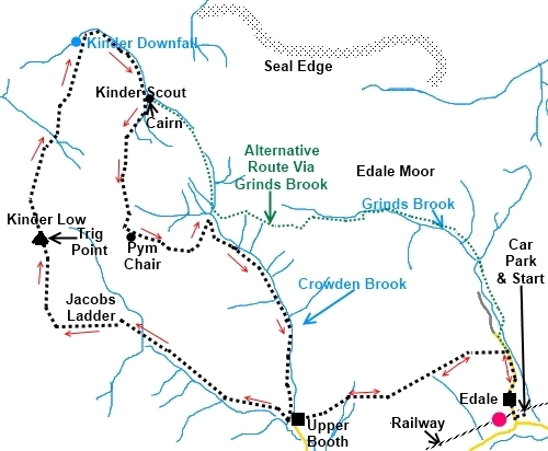
Introduction: This walk
on Kinder Scout starts from the
hamlet of Edale and takes you over the exposed plateau of Kinder Scout to
Kinder Downfall via Jacobs Ladder, across the plateau to the southern edge
to see some of the weird shaped rocks and the very steep descent of Crowden
Clough. There are good views across the Cheshire Plain to Manchester and
South to the Mam Tor ridge. A paradox of this walk is that to appreciate the
best of Kinder Downfall with its 30 metre waterfall, there needs to have
been plenty of recent rains yet the walk as a whole is best done after a
long dry spell as Kinder Scout is essentially a huge peat bog! From Kinder
Downfall there is an alternative route to Edale via Grinds Brook (shown on
the sketch map in green) with a probably better defined path but this would
miss out some of the weird shaped rocks and the famous Pym Chair.
Kinder Scout is famous as
the site of a mass trespass in 1932 from which stemmed the majority of the
public rights of access to the countryside that we enjoy today. The moorland
is designated as “open country” with “Right to Roam” access.
Some safety points.
Firstly, I can almost guarantee that if cloud descends on the featureless
plateau, you will get lost unless you have a compass and know how to use it.
The section from the cairn across to Pym Chair is extremely boggy and
progress is impeded by metal shuttering installed to retain moisture. So, it
is hard work! Secondly, the descent of Crowden Clough is incredibly steep and slippery
after rain. Walking Poles will help. This is also a good walk on which to
use gaiters.
Edale is most easily
reached by turning north off the A6187 at Hope between Hathersage and
Castleton. There is a pay and display car park with toilets at Edale from
where the walk starts (SK 124853).
%20The%20Old%20Nags%20Head.jpg)
Start: Leave the car park via the
pedestrian access next to the toilets and turn right passing the Moorland
Centre and Edale Parish Church. Continue to the Nags Head pub and here take
the path to the left signed by the finger post for the Pennine Way (with the
acorn symbol) and Upper Booth (SK 123860). At a stile, keep straight ahead
on the Pennine Way. Stay on the main track ignoring any routes off to the
right.
%20Panorama.jpg)
At the enclave of Upper
Booth, the track passes between the farm buildings turning left past a red
post box in the barn wall. As you get to a junction with a red telephone
box, turn right staying on the broad track (SK 102853). A finger post
confirms the Pennine Way and Jacobs Ladder 1 mile. Cross the stream and over
the bridge ignoring the footpath on the right and stay on the main track to
Lee Farm where there is a small information centre (SK 096855).
The track passes between
the buildings and soon you come to Jacobs Ladder indicated by a National
Trust Sign. It derived its name from one Jacob Marshall who farmed in Edale
in the 1700s and cut steps in the hillside to make it easier to climb. The
steps are now “manicured” stone ones. Climb these.
%20Jacobs%20Ladder.jpg)
%20Cairn%20above%20Jacobs%20Ladder.jpg)
Where the track at a couple
of junctions, keep right and head for the large stone outcrop you can see
comprising 8 main “blocks” at Edale Rocks (SK 079867) . There are some
good sandwich spots here!
%20Edale%20rocks.jpg)
%20Pym%20Chair.jpg)
Keep straight ahead here
and you will soon catch sight of the trig. point (SK 079870). The track
passes to the left of it, heading north before bending north north east.
Follow the edge of the plateau and if the weather is clear you will see
Manchester to the west and plane activity at the airport.
%20Trig%20Point%20at%20Kinder%20Low.jpg)
%20Overlooking%20Kinder%20Reservoir.jpg)
The sight of Kinder
Downfall is unmistakable, a deep cleft in the plateau with the stream
tumbling over the edge (though very tranquil on my visit) (SK 083889). From
here, turn right and follow the stream across the plateau. The path varies
between right and left of the stream, is indistinct in some places and could
be tricky if the stream is in full flow.
%20Kinder%20Downfall.jpg)
At a fork marked by a small
cairn (SK089884), the “official” footpath branches left (alternative
route in green on the sketch map) and heads directly to Grindsbrook Clough
but this walk remains with the main stream, making use of the open access
rights, heading south to see some of the unusual rocks not least Pym Chair.
If the peat is boggy, I recommend you stay on the alternative route.
As the stream peters out,
bear left. There is a faint path but you have to weave around some metal
pilings inserted into the peat as part of the preservation works. As you
reach the higher ground, you will see stone cairn. Head for this and you
will then see a large outcrop of rocks known as The Woolpacks on the
southern edge of the plateau – Pym Chair is just to their right (west) (SK
088870). Make your way across the moor to these.
%20Approaching%20Pym%20Chair.jpg)
Turn left at the rocks and
follow the faint path descending until you meet the clear main track. Turn
left on this and follow it for about 1½ miles. You come to Crowden Clough
(SK 095872), another unmistakable
cleft in the plateau with the very steep path starting in an easterly
direction at its head.
As Crowden Clough levels
out, follow the stream down the valley to Upper Booth then turn left and
retrace your steps to Edale.
%20Woolpacks.jpg)
If you need to buy any hiking
equipment/clothing before your trip see the Hiking
Store
All information on this
site is given in good faith and no liability is accepted in respect of any
damage, loss or injury which might result from acting on it.
|


.jpg)
.jpg)
.jpg)