|
Mam
Tor Circuit
Starting point and OS Grid reference: 
Hope
village
- SK171835 - Parking in small pay & display cp.
|
Ordnance Survey Map
OL1
The Peak District – Dark Peak Area.
Buy this map from
List
of OS Maps
.Note: If you use OS Maps on-line, you can download this route via this
link.
| |
Distance: 8 Miles
|
Date of Walk: 17 October 2010
| |
Ascent:
Descent:
See Walking Time Calculator
|
1597ft (487m)
1599ft (487m)
| |
Traffic
light rating: 

(For explanation see My
Walks page)
| |


For advice on .gpx files see
My Walks page
|

Click
the PDF logo above to give a printable version of this walk without the
photos.
|
To
view route as a dynamic Ordnance Survey map click here.
Introduction: A popular,
straightforward walk over the ridge above Castleton, taking in Lose Hill (or
Wards Piece, named in honour of George Herbert Bridges Ward who
pioneered rambling, forming the first rambling club in Britain and worked
assiduously for the rambling rights we know today ), Mam Tor, and Castleton
itself where a welcome pint can be had.
Start the walk in the village of Hope
(SK171835) where there is a pay and display car park opposite Hope Garage.
Start: Turn right out of the car park and take
the left turn on the road to Edale alongside the Old Hall hotel. Walk along
this road until you see the road on the right signposted Hope Cemetery. Just
opposite this junction on the left is a narrow stone stile and finger post.
Take this path (SK171839).
Follow this path just past the farm
buildings where there is a “crossroads” of paths with a four way finger
post. Turn right. Follow this path straight ahead and over the railway.
Continue straight on ignoring two footpaths on the left in a north westerly
direction, passing an old barn then stay on the right hand side of the wall
past Losehill Farm (SK159847).
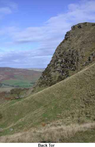
The clear path now rises to Lose Hill
itself (476 metres/1562ft) (SK153854) where a round orientation table marks the summit. Views stretch out
before you of Edale and Kinder Scout. Head left (westwards) following the
paved path. After going over Back Tor (SK145850) be sure to look back to
appreciate the view of its precipice.
%20View%20over%20Hope.jpg)
%20View%20to%20Win%20Hill.jpg)
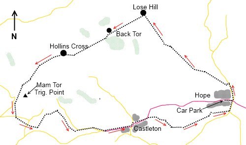
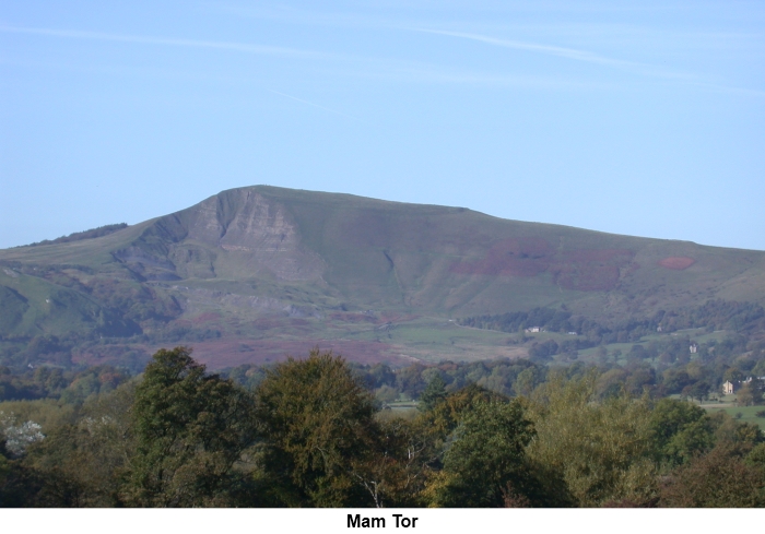
The path now continues via Hollins Cross
to Mam Tor itself with its trig. point (517 metres/1696 ft) (SK128836) and
stone flagged area with interesting art inset. Here there are magnificent
views of the Hope Valley with its prominent cement factory and Castleton.
%20Looking%20back%20along%20the%20ridge.jpg)
Descend down the obvious path to the
road, turn left and take the path on the left. Cross one field to another
road, the A6187 (SK126831). Across the road you will see a gate and finger
post. Go through this gate. Almost immediately the path forks and you want
the left fork. Follow the path across to the B6061 and go straight across
through another gate. Follow this path to the first farm you come to Winnats
Head Farm. The path passes to the left (North)
of the farm but at the farm, turn left (North). This track may not be too
clear and it heads to the Blue John Cavern.
Pass in front of the cavern buildings
and immediately opposite is a small gate. Go through it and follow the
footpath which curves round to Treak Cliff Cavern. Descend the path from
Treak Cliff to the road. Follow
the main road through the centre of Castleton.
As you are leaving Castleton, watch out
for a green metal sign on the right “Public Footpath to Hope” (SK154831)
indicating a broad track. Follow this track which eventually
becomes a normal and well walked footpath following the course of
Peakshole Water. Cross the railway and continue until you reach a country
lane. Turn left and it will take you into Hope.
%20Mam%20Tor%20summit%20and%20trig..jpg)
If
you need to buy any hiking equipment/clothing before your trip see the Hiking
Store
All information on this
site is given in good faith and no liability is accepted in respect of any
damage, loss or injury which might result from acting on it.
|


.jpg)
.jpg)
.jpg)