
|
|
|
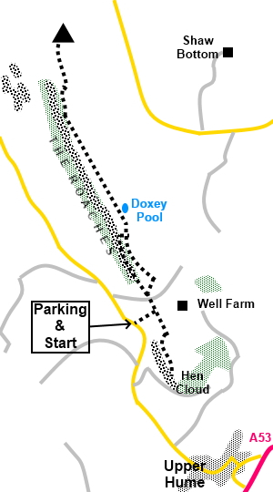
To view route as a dynamic Ordnance Survey map click here. Introduction: The Roaches are a dramatic rocky ridge on the far western side of the Peak District. Consequently, they are often thought to be in Derbyshire though are in fact in Staffordshire. They are a coarse sandstone, generally referred to as gritstone, beloved of rock climbers and indeed, you are likely to see climbers when doing this walk, not least because there is a climbing school nearby. The name “Roaches” is believed to have come from the French for rock, “Roche”. At their highest point, they rise to 1657ft (505m), well above the surrounding area and so give a fantastic view all along their length. Separated from the main ridge is Hen Cloud but this is worth the modest climb in itself because its rocks at the summit really complement the views. On top of The Roaches is Doxey Pool, a small tarn, supposedly inhabited by a mermaid who entices the unwary into the pool to join her. As with all good mermaid stories, I was disappointed (again!). This is a circular short walk of only 3.4 miles. I kept it short because bad weather was expected but the walk could easily be extended to include Back Forest and the cave Lud’s Church and/or Ramshaw Rocks, another impressive, if shorter outcrop overlooking the A53. However, one bonus of doing it this way was that I walked along the bottom of The Roaches first and their towering mass against the sky was quite a site. I also had time to soak in the vistas. The summit path along the ridge is fairly level though there is a slightly challenging descent, although there is an easier path round (SK 005626). However, you will miss some of the best bits of the ridge if you take this route. There are some steep drops on this walk, especially if you are looking for the photo opportunities, so care is needed. The walk starts from a lay-by on a minor road off the A53, about 3 miles north of Leek, signposted for Upper Hulme. This is a road which loops back to the A53. Turn off this loop road (unsigned) and simply follow the narrow road. There are many lay-by parking areas giving some idea of how popular The Roaches are. I parked in the third lay-by which sits between Hen Cloud and The Roaches. Start: Just by the lay-by (SK 006619), turn right indicated by a fingerpost, through a walkers gate. There is a yellow public footpath arrow.
Climb the hill on the broad green path ignoring the first gateway. When the path divides, keep straight ahead. As the hill levels out at the col, turn right through a walkers’ gate (SK008620) and follow the obvious path to the summit of Hen Cloud (SK 009616).
Return the same way to the gate and go straight across the col and through another gate and follow the path straight ahead.
When the path divides, keep left to follow the bottom of the crags. Just after going through an old gateway, there is a great view (SK 006623).
Continue on the path through the trees, where you get the spectacular skyline created by the crags. When you meet another path at a ‘T’ junction of paths, turn right to climb the gap between the crags (SK005625).
At the top of the hill, turn left, following the well trodden path to the right of the dilapidated wall.
At SK 004628, pass Doxey Pool.
Continue along the ridge to the trig point (SK 001639).
Return the same way but on meeting the point where you climbed up from the trees, continue along the ridge.
You reach a point where you start you descent from the ridge down the ‘nose’ of the ridge back to the col. This is a little tricky and care is needed.
Continue the descent until you come to an obvious large gap on the left, through which is a view to a derelict farmhouse. Turn left through the gap and follow the path down to the col. A right turn here will return you to the parking area.
If you need to buy any hiking equipment/clothing before your trip see the Hiking Store All information on this site is given in good faith and no liability is accepted in respect of any damage, loss or injury which might result from acting on it.
| | |||||||||||||||||

.jpg)
.jpg)
.jpg)
%20Hen%20Cloud%20From%20The%20Road.jpg)
%20Hen%20Cloud.jpg)
%20View%20from%20Hen%20Cloud%20with%20Tittesworth%20Reservoir.jpg)
%20Rock%20outcrops%20on%20Hen%20Cloud.jpg)
%20Eroded%20rocks%20on%20Hen%20Cloud.jpg)
%20SE%20End%20of%20the%20Roaches.jpg)
%20View%20from%20the%20Roaches%20to%20Hen%20Cloud.jpg)
%20Crags%20on%20the%20Roaches.jpg)
%20Crags%20on%20the%20Roaches.jpg)
%20Looking%20along%20the%20summit%20path%20of%20the%20roaches.jpg)
%20Doxey%20Pool.jpg)
%20Dramatic%20Rock%20Strata%20on%20the%20Roaches.jpg)
%20Trig%20Point%20on%20the%20Roaches.jpg)
%20View%20North%20from%20the%20Roachesw.jpg)
%20View%20of%20part%20of%20the%20descent.jpg)
%20The%20gap%20to%20look%20for%20on%20the%20descent.jpg)