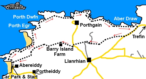
|
Abereiddy
to Porthgain
|
Starting
point and OS Grid reference:

Free
car park at Abereiddy (SM797321)
|
Ordnance
Survey Map
OL35
– North Pembrokeshire.
Buy this map from
List
of OS Maps
Note: If you use OS Maps on-line, you can download this route via this
link.
| |
Distance: 5.86
miles
| |
Traffic light rating:


(For explanation see My
Walks page)
| |


For advice on .gpx files see
My
Walks page
|

Click
the PDF logo above to give a printable version of this walk without the
photos.
|

To
view route as a dynamic Ordnance Survey map click here.
Introduction:
Abereiddy is spelt as two words on
the OS map but locally on signs as one, so on the basis that the locals know
best, I use the one word version.
This is a short easy walk
which takes you on an interesting journey through some of Pembrokeshire’s
industrial heritage and amongst some dramatically indented coastline with
sheer cliffs. Refreshments are available in Porthgain (notably the Sloop
Inn) and there are a couple of interesting galleries/shops. Public toilets
are available in Porthgain and at Abereiddy (a cream building set back from
the beach).
The walk begins from the
large free car park at Abereiddy. To get there, turn off the A487 Fishguard
to St. Davids road at Croes-goch on to a side road signposted Abereiddy
Beach. Turn right at the first junction then straight across at the
crossroads.
Start:
From Abereiddy car park (SM797321) and facing the sea, turn right.
Where the coast path starts, there is an interesting information board which
tells you about the slate quarrying which used to go on here. Before going
far on the coast path, it is worth turning left at the first finger post to
see the aptly named Blue Lagoon (SM
795314), a remnant of the slate industry with ruined buildings. It is
popular for “coasteering”.
%20Blue%20Lagoon.jpg)
%20Ruins%20at%20Blue%20Lagoon%20and%20Tower.jpg)
%20Way%20to%20Tower.jpg)
(To look at the round tower
you can see on the cliff tops (SM 793395) and which is referred to on the
information board, you need to descend a cleft from the cliff tops then
climb up to it – see photo above).
%20Bay%20North%20of%20Abereiddy.jpg)
Retrace your steps to the
fingerpost and follow the coast path signs designated by the acorn sign, to
Porthgain. En route, you pass ruined buildings connected with brickmaking
and note the tall cone shaped structures as you approach Porthgain, on the
cliffs at either side of the channel to the harbour. One is painted white
(SM 814327). These would have been used to guide boats to the
entrance.
%20Entry%20Channel%20to%20Porthgain.jpg)
%20Porthgain.jpg)
As you get close to the
harbour, originally built in 1851, there is a massive brick built edifice on
the right. This is the remains of the old brickworks which was in its heyday
from 1889-1912.
%20Coastline%20Near%20Porthgain.jpg) From Porthgain, follow the coastal path north
passing the white channel marker at close quarters. Stay on the path until
it meets the road just before the village of Trefin (SM 833324). Turn right
and walk along the road passing a house called Awel-for on the right.
From Porthgain, follow the coastal path north
passing the white channel marker at close quarters. Stay on the path until
it meets the road just before the village of Trefin (SM 833324). Turn right
and walk along the road passing a house called Awel-for on the right.
One field beyond the house,
look out for a footpath on the right indicated by a fingerpost (SM 829321)
and go diagonally across the field and through the gate. Turn left and
follow the fence and banking on the left.
The footpath becomes a
broad track which takes you to a farm (SM 819319) (Henllys). Here, bear left
following the fingerpost for Porthgain.
As you approach and pass a
group of white cottages (at Felindre House), ignore the first fingerpost on
the right but turn off at the second over a stile (SM 817319). Follow the
right hand boundary of the field to the stone stile at the end (heading in
the direction of the white buildings ahead). You will soon see a stile next
to a power pole which exits into the road (SM 814310).
Turn left and immediately
right to Barry Island farm according to the map but represented in actuality
by a sign “Ynys Barry Holiday Cottages and Lodges”. At the junction of
the tracks, keep right. A sign soon advises that the road to the beach is
closed to all vehicles – footpath only – although it is a tarmac road
for a while.
As you pass between two
sets of white painted gateposts, the tarmac stops and it becomes a rougher
track. Pass a three way fingerpost and follow “Abereiddy 1 mile”
straight ahead.
At a gateway with another
three way fingerpost, continue following the sigh for Abereiddy.
The track enters a field
where there is yet another three way fingerpost. Turn left. The footpath
route actually goes diagonally across the field to a stile but if the field
is in crop, be charitable and walk round its edge (it is only a small
field).
Over the stile and the car
park where you started will be clearly visible. Follow the obvious path to
it.
If you need to buy any hiking
equipment/clothing before your trip see the Hiking
Store
All information on this
site is given in good faith and no liability is accepted in respect of any
damage, loss or injury which might result from acting on it.
|
