
|
|
|
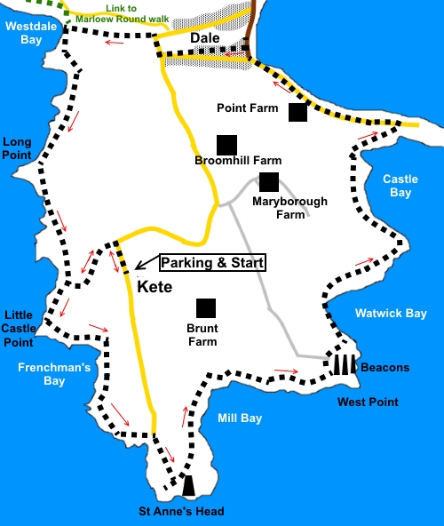
To view route as a dynamic Ordnance Survey map click here. Introduction: This walk explores At Anne’s Head, west of Milford haven. As with much of Pembrokeshire, there are superb coastal views and dramatic cliffs. It starts from an area known as Kete, on the edge of what was once a Royal Naval base, which was used in World War II for training radar technicians and Fighter Direction Officers. Their job was to detect enemy aircraft. The radar equipment was near the coast but in the early days aircraft could not be spared so Walls Ice Cream vans were requisitioned. One trike would be an “enemy aircraft” and the Fighter Direction Officers would direct other “fighter” trikes to attack it. Eventually, it was decided real planes would be better! Some of the concrete “flight paths” can still be seen. At St. Anne’s head is the white painted lighthouse, known as St. Anne’s Low Light. A rebuild was completed in 1844 but this and the older lighthouse nearby (converted into an observation tower just before World War II), the “High Light” were originally built in 1714. There are various connected cottages nearby, now holiday cottages. Nearby is a must see section of cliffs at Cobbler’s Hole where the rock strata synclines (down-folds) and anticlines (up-folds) are very clearly visible in the red sandstone. Just past St. Anne’s Head, you arrive at Mill Bay. Here Henry Tudor landed on 7 August 1485, from France, on his way to clobber Richard III at the Battle of Bosworth on 22 August 1485. Evidently he has 55 ships and 4000 men. Henry thus became Henry VII, Henry VIII’s dad. The rest is history! On then to the pretty village of Dale. Here you can get refreshments at pub or café before walking via what remains of medieval Dale Castle, which was originally owned by the De Vale family. Its situation was one reason why Henry VII landed at Mill Bay – it could not be seen from the castle. Dale is a popular boating centre. The walk starts from a somewhat remote National Trust car park at Kete but for a change, it is free! You could of course start from Dale as it is a circular walk. To get to Dale, follow the B4327 from the circular one way system in Haverfordwest and follow the road signs. The B4327 ends at Dale. Turn right in Dale and follow the road for one and three quarter miles. The NT car park is obvious and on the right. Note if you wanted a more demanding walk, you could combine it with the Marloes Round walk, as a short half-mile walk on the coast path would link the two. This would give you an overall distance of around 16/17 miles. Start: Exit the car park (SM 803042) and turn left along the road. As the road bends right (SM 803044), turn left through a kissing gate and follow the concrete track. At the end of the concrete, go through another kissing gate and bear right to another. Through this, join the coast path and turn left.
Essentially, all you need to do now is keep the sea on the right and follow the coast path.
The route comes to the access track to the St. Anne’s Head lighthouse complex (SM 805032). Turn right following the Coastal Path fingerpost. Just before the lighthouse is a diversion to the right which is worth the detour for the view but also to see the dramatic rock strata.
Return to a walker’s gate off the road, by the big yellow “Private” sign painted on the road and through this, turn 90° right. It has to be pointed out that this is not the most direct route for this short section but is the “official route” and the one the property owners want you to take. Follow the fence round in front of the houses before turning left to follow the fingerpost.
Follow the obvious Coastal Path, passing the large rock with plaque commemorating the landing of Henry Tudor, on his way to defeat Richard III in 1485 (SM 808034). At SM 817036, are three navigation marker beacons. At the broad track to one of the beacons, just cross straight over to follow the coast path, following the direction of the fingerpost.
Just past here at SM 818036, is a stone bench which makes for a handy lunch stop. At SM 815041, pass a path which drops down to a sandy beach at Watwick Bay.
At SM 821044, pass a large single navigation beacon. At SM 818050, cross a bridge at Castle Beach. At SM 821052, is an apparent right turn, which you could be forgiven for expecting that it would take you out to Dale Point. However you would be disappointed because after not very far, the way is blocked by barbed wire (I tried it!). This area is the private domain of the Dale Fort Field Centre. When the path meets a tarmac lane, turn left along it, to arrive at the very attractive Dale, a small resort with lots of boating activity. There are pub and café opportunities for refreshments.
At the road junction, turn left following the road signs for St Anne’s Head and Milford Haven. As the road bends right, follow it round, following the road sign for Haverfordwest and Milford Haven. At the next bend, by Dale Castle, a 13th Century castle remodelled into a house in 1910, into turn left, following a fingerpost for the Coast Path.
As the broader track turns left, turn right through a walkers’ gate, signposted to the Coast Path. After a short walk along a broad valley, go through a kissing gate and turn left to follow the coast path, indicated by the “acorn” sign.
Continue until you reach a section where there is a banking on the left hand side, probably connected with an Iron Age fort which stood nearby. Follow to the first gap where there is a water trough. Turn left here and retrace your steps to the car park. If you need to buy any hiking equipment/clothing before your trip see the Hiking Store All information on this site is given in good faith and no liability is accepted in respect of any damage, loss or injury which might result from acting on it.
| | |||||||||||||||||

.jpg)
.jpg)
.jpg)
%20View%20to%20Wooltack%20Point%20nad%20Skomer%20Island.jpg)
%20Great%20Castle%20Head.jpg)
%20St%20Annes%20Head.jpg)
%20Old%20lighthouse%20St%20Annes%20Head.jpg)
%20Dramatic%20folded%20rock%20strata%20at%20St%20Annes%20Head.jpg)
%20New%20lighthouse%20St%20Annes%20Head.jpg)
%20Looking%20back%20at%20St%20Anne's%20head%20across%20Mill%20Bay.jpg)
%20Watwick%20Bay.jpg)
%20Watwick%20Bay%20beach.jpg)
%20Sea%20front%20at%20dale.jpg)
%20Remains%20of%20Dale%20Castle.jpg)
%20Looking%20back%20to%20Dale.jpg)