
|
|
|
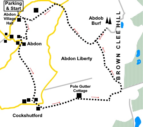
To view route as a dynamic Ordnance Survey map click here. Introduction: The summit of Brown Clee Hill, called Abdon Burf, is the highest point in Shropshire at 1770ft (540m). There was once an Iron Age fort here. It is now topped by various radio/radar installations resulting in some rather unsightly masts. However the compensation is that the views over Shropshire are fabulous and you realise what a pretty county it is, being very rural and lacking, in this immediate area, any major towns/cities. A topograph outlines various landmarks including Wenlock Edge and Long Mynd. During World War II, there were a number of plane crashes on this hill of both German and Allied aircraft. It is possible that more aircraft crashed on the Clee Hills than any others – around 19 with the loss of 43 lives. A memorial you will pass commemorates 23 who died on Brown Clee Hill itself. En route, you pass through the delightfully named Cockshutford! The walk passes Pole Gutter cottage which was a post Medieval ‘Squatter Cottage’, a squatter’s encroachment on Clee Liberty common. The term does not have the same connotation as squatter today and was a feature of about the 17th Century when labourers were allowed, even encouraged to build a cottage in order to work in the landowner’s local quarries or mines. The walk starts from the car park of Abdon village hall where walkers are allowed to park to explore the hills. There is a voluntary donations box – don’t be mean! Getting to Abdon is a navigational challenge in itself, along narrow lanes and far too complicated to try to explain. Use an atlas/sat. nav. The link to Google maps on the web page will give directions. Start: From Abdon village hall, exit via the five bar gate in the back left hand corner of the car park. Cross the field to the stile and bear right in the direction of the yellow arrow, you need to head for the very far, right hand corner of the field. Descend into the gully and turn right through a walkers’ gate (SO 578865).
Follow the drive to the right of the cottage and just after the gate, turn left over a stile and immediately right, following the yellow arrow. [Note: It is worth saying here that I am not sure I followed the best route. According the OS map and the Shropshire Definitive Map, which I checked on my return home, there is a Right of Way directly along the drive to the road but for whatever reason, I was sidetracked by the arrows and stiles. You will have to decide for yourself. I describe the route I followed.] After a hundred yards or so along the field, cross a stile on the right and follow the footpath through the trees, emerging at a cottage. It is not easy to find your way through the trees but if is not far and you cross a plank footbridge to reach the cottage. Turn left to the road. At the road (and this applies which ever way you follow – see note above), turn left (SO 577863). Pass Manor House Farm and as the road bends right, turn left along a broad track indicated by a yellow arrow. There is a fingerpost for “Brown Clee Hill 0.9 mile 30 minutes”. However the writing is on the reverse side of the fingerpost! Arrive at two farm gates and take the left one, then follow the right hand boundary. As you get almost to the end of the field, bear left i.e. do not go through the gate directly ahead but bear left through a gateway indicated by a yellow arrow. Cross a stile and head to the diagonally opposite corner of the field. In this large field, go to the very point of the diagonally opposite corner, ignoring a stile to the right which is clearly marked as not being a public footpath. In the corner of the field is a stile, which you cannot see until you are almost at it. Cross the stile and turn right following a yellow arrow (SO 580855), following the right hand boundary. At the end of the field, cross a stile and drop down to the far left hand corner of the next field and cross the stile and footbridge. Arrive at a broad track and turn left to the road by a phone box and left again along the road. After only fifty yards or so, before crossing the bridge over the stream, turn right along a broad gravel track. At a five bar gate, simply continue along the broad track. A sign tells you are entering Clee Liberty Common. When the track bends sharp left (SO 585851), leave it in a straight ahead direction, on the green track. You now follow this obvious route, climbing steadily, passing Pole Gutter Cottage, half hidden in the trees (SO 588852), until you reach the top by what is shown on the OS map as an information centre but what in reality was just an enclosed area in the trees, with a notice board and a bench or two (SO 597853). Without going into this area, turn left, heading towards the radio masts.
The views west as you climb and from this point are beautiful.
Head for the gate and through it, follow the obvious path indicated by the arrow on the gatepost for “Shropshire Way Main Route”. After a few yards, branch off to the right to see a memorial (SO 596855) to twenty three Allied and German airmen who died in crashes during WWII. Turn left at the memorial to rejoin the main path and continue towards the radio masts.
When the track divides, follow the right fork to the summit. An unusual feature of the ‘Trig. Point’ is that the Flush Bracket Benchmark plate normally seen on the side of the pillar, in this case is set into the top step leading to the topograph. The three grooved mounting point for the theodolite is a few steps lower.
Retrace your steps and go through the gate ahead. Continue straight ahead on the clear descending track, which soon curves right.
Continue to follow it ignoring any turns off, including where it crosses another section of the Shropshire Way (SO 587866) until you reach the road. Turn right along the road to a road junction by a phone box (now a mini-library!) and turn left.
After about a hundred yards, turn left at a bridleway fingerpost, with a blue horseshoe. Follow the left hand boundary in this and the next field. In the third field, continue in the same direction, ignoring a footpath immediately off to the right over a stile. Continue keeping the line of trees on your left, until you are about two thirds of the way along the field. Turn right here to a stile in the fence which you crossed on your outward journey. Cross this and the last field to return to the car park. If you need to buy any hiking equipment/clothing before your trip see the Hiking Store All information on this site is given in good faith and no liability is accepted in respect of any damage, loss or injury which might result from acting on it.
| | |||||||||||||||||

.jpg)
.jpg)
.jpg)
%20Brown%20Clee%20Hill.jpg)
%20Pole%20Gutter%20Cottage.jpg)
%20Looking%20up%20the%20path%20to%20Brown%20Clee%20Hill.jpg)
%20Looking%20down%20the%20path%20on%20Brown%20Clee%20Hill.jpg)
%20View%20west.jpg)
%20The%20information%20point.jpg)
%20Memorial%20to%20airmen.jpg)
%20Looking%20along%20Brown%20Clee%20Hill%20to%20Clee%20Burf.jpg)
%20Summit%20of%20Abdon%20Burf.jpg)
%20Masts%20on%20Abdon%20Burf.jpg)
%20View%20East%20from%20Abdon%20Burf.jpg)
%20View%20north%20from%20Abdon%20Burf.jpg)
%20Topograpf%20with%20Trig%20point.jpg)
%20View%20on%20the%20descent%20path.jpg)
%20Phone%20box%20library.jpg)