|
Addingham to Bradley Via Skipton Moor
Starting point and OS Grid reference:

Addingham
- Roadside parking on Turner lane (SE065499)
|
Ordnance Survey Map
OL
21 South Pennines.
Buy this map from
List
of OS Maps
Note: If you use OS Maps on-line, you can download this route via this
link.
| |
Distance:
11.5
miles
|
Date of Walk:
8 February 2012
| |
Ascent:
Descent:
See Walking Time Calculator
|
1646ft (502m)
1646ft (502m)
| |
Traffic
light rating: 

(For explanation see My
Walks page)
| |


For advice on .gpx files see
My Walks page
|

Click
the PDF logo above to give a printable version of this walk without the
photos.
|
To
view route as a dynamic Ordnance Survey map click here.
Introduction:
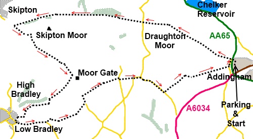
Starting from Addingham in Wharfedale,
West Yorkshire, this walk starts following the ancient route from Addinham
to Skipton but stops short of Skipton and curves south west across a higher
part of Skipton Moor to picturesque Bradley in Airedale, an ancient spinning
and weaving village. The Leeds/Liverpool canal passes the outskirts of the
village and you will catch glimpses of it. One of the best aspects of this
walk is the opportunity to indulge in excellent food and beer at the cosy
Slaters Arms in Bradley.
The walk starts from Turner Lane (SE065450)
in Addingham, a “dead end” road with plenty of parking space just
beyond the main housing. To get there, turn off the A65 between Iklley and
Skipton at the roundabout at the western end of the bypass on to the B6160
towards the village. Take the first left (Moor Park Way), left again (Moor
Park Drive) and left at the end on to Turner Lane.
Start:
Having parked, walk back along Turner Lane to its end and turn left on to
Moor Lane (SE 066500). Moor Lane is interrupted by the main road village
by-pass which you cross and continue along the metalled road as it begins to
rise.
%20View%20over%20Chelker%20Reservoir.jpg)
%20Old%20Milestone.jpg)
%20View%20North%20to%20Buckden%20Pike.jpg)
%20View%20North%20with%20Skipton.jpg)
%20View%20over%20Skipton.jpg)
Eventually, the tarmac gives way to a stony
track which continues to rise until it reaches a minor road where there is
an ancient milestone (SE 040511). Cross this road and the track levels out
and continues straight ahead, becoming a walled track and passing a conifer
plantation on the right before descending through deciduous trees. As you
descend amongst these trees towards Skipton look out for a stile on the left
with a white arrow and cross this (SE 005510).
Follow the path as it climbs the hill passing
beneath a small rocky outcrop. Here, cross a gated stone stile. Go straight
ahead across the open moorland, ignoring the path off to the left.
Essentially, you are roughly following the wall on the right but the path
swings away left at first climbing steadily.
As you join a track from the left, go right.
At a fork where a couple of land drains empty into a hollow, take the right
fork, your line being towards the power pole on top of the hill.
The path forks at a post with two yellow
footpath arrows. Go right.
Cross a stone stile at the top of the hill
and follow the wall on the right until it starts to turn away to the right
and the path forks, take the left hand fork indicated by a yellow footpath
arrow.
The path descends to a stream then up the
other side towards another post and some large rocks. There are good views
from here towards Pendle Hill.
%20View%20west%20from%20Skipton%20Moor.jpg)
Cross the next stile and walk diagonally
across the next field to another stile in the far corner.
The next field is a large one sloping
downhill with a barn built into the left hand boundary wall. Walk diagonally
down this field to the far corner heading towards Moor Gate farm. Go through
the gateway (SE 020496) at the bottom of the field, and turn right to head
towards the next farm (Higher House Farm). Go over the stile/through the
gate and follow the farm track down past the farm buildings and Lower House
Farm a little further on.
Continue to follow the track as it curves
left passing beneath some power lines. This track leads down into Bradley.
On reaching the road, turn left along Main Street. If visiting the Slaters
Arms, continue along Main Street and
as it curves left to become Crag Lane, you will see the pub. Otherwise, turn
left at St Mary’s Church (SE 005483) along Silsden Road (leading to
Jackson’s Lane).
Stay on this road as it climbs quite steeply,
passing Wishburn Farm. Just past the national speed limit signs, ignore the
footpath on the right and the next on the left, both indicated by
fingerposts.
%20Looking%20Back%20Towards%20Bradley.jpg)
As the road bends to the right, look out for
a fingerpost on the left indicating a public bridleway (SE 013484). Go
through the gate but instead of following the bridleway straight ahead, bear
right to walk diagonally across the field and go through the gateway at the
top right hand corner, turning right as indicated by the yellow arrows and
follow the wall.
Cross a gated stile in this wall and turn
left. Go through a gate into the next field and follow the right hand wall
in this field. Go right into the next field which gradually narrows and go
over the stile at the end. At the end of the next field, turn right to the
road (SE 025489).
Turn left at the road then right at a
fingerpost for Becka Close Lane (SE 023491). Follow the wall along by the
trees on the right then over a wooden stile. Go through another gate then
bear left diagonally across the next field to the farmstead Jenkin (SE
029494). Go round the right hand side of it into its lane and turn right.
%20View%20towards%20Ilkley%20Moor.jpg)
Go over a cattle grid on to the road, turn
right then immediately left indicated by a green public footpath fingerpost.
This takes you to Schoolmaster Farm. Pass in front of the farmhouse and stay
on the broad track. As it bends to the right (SE 036496), go into the field
ahead and cross it diagonally to exit into the road (Walkers Lane). If you
miss the way in to the field (as I did!) just stay on the track to the road.
Turn left at the road. Walk along the road,
ignoring the first road on the left (Jowetts Lane) until you get to Bank
Lane. Turn left here and almost on the junction on the right take the public
bridleway indicated by the fingerpost (SE 046492).
You are now in a very long series of narrow
fields. Walk along these until you exit at a walled lane where you turn
right.
At the road, turn left and as it curves to
the left, turn right to cross the by-pass and retrace your steps to Turner
lane where you started.
If you need to buy any
hiking equipment/clothing before your trip see the Hiking
Store
All information on this
site is given in good faith and no liability is accepted in respect of any
damage, loss or injury which might result from acting on it.
|


.jpg)
.jpg)
.jpg)