|
Barwick-in-Elmet
Circular
|
Starting
point and OS Grid reference:

The
maypole in Barwick-in-Elmet (SE 340375) – on street car parking.
|
Ordnance
Survey Map
Explorer
Map 289 - Leeds, Harrogate, Wetherby and Pontefract.
Buy this map from
List
of OS Maps
Note: If you use OS Maps on-line, you can download this route via this
link.
| |
Distance: 9.8 miles
| |
Traffic light rating:

(For explanation see My
Walks page)
| |


For advice on .gpx files see
My
Walks page
|

Click
the PDF logo above to give a printable version of this walk without the
photos.
|
To
view route as a dynamic Ordnance Survey map click here.
Introduction:
This is an ideal walk for anyone
wanting something of respectable length but almost wholly flat, as it
follows well defined bridle paths and course of old railway tracks. It
starts at Barwick-in-Elmet, a village which survives from the ancient Celtic
kingdom of Elmet. It dates back to several hundred years BC and there are
ancient earthworks in the area, some of which are passed on this walk. Its
main claim to fame nowadays is its huge maypole standing some at 86 feet
which is the subject of a Spring Bank Holiday festival every three years to
re-erect it, after routine maintenance.
The walk passes through Aberford where there
are a couple of pubs, notably the Arabian Horse, for refreshments.
Parking is a case of finding an on street
spot. As a common reference point, the walk starts at the maypole which is
by the Gascoigne Arms in the centre of the village.
%20Barwicks%20famous%20maypole.jpg) To get to Barwick-in-Elmet (pronounced “Barrick”),
turn off the A64 where signposted, about 1¼ miles north east of the Leeds
Ring Road (A6120). To get to Barwick-in-Elmet (pronounced “Barrick”),
turn off the A64 where signposted, about 1¼ miles north east of the Leeds
Ring Road (A6120).
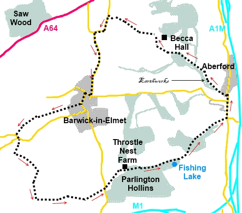
Start:
With your back to the maypole (SE 340375) and the Gascoigne Arms on your
right, proceed along Main Street. Turn right on Carrfield Road. Cross over
Elmwood Lane staying on Carrfield Road which eventually continues as a broad
rough track, the public right of way being indicated by a fingerpost.
At a metal kissing gate, turn right to follow
the hedge line. At the next gateway, turn left to follow the direction of
the yellow footpath arrow. On reaching the road on the outskirts of Scholes
(SE 383365), turn left and first right on to Leeds Road. Immediately after
turning, take the track on the left signposted Public Bridleway and bearing
an owl motif, indicating this section is part of the Leeds Country Way.
When the track splits at a four way
fingerpost, turn left remaining on the public bridleway. The track follows
the outside of a small wood. Ignore a broad track on the left and pass the
barrier which says “Authorised Vehicles Only”.
Ignore a footpath on the left.
When the path splits, bear left.
At a crossroad of tracks (SE 388350), turn
left. Stay on the main track straight ahead through the golf course,
ignoring any turns off and come out past a farm. Stay on the farm track to
the road and cross over heading for Throstle Nest Farm. As you get to the
farm (SE 409357), branch off to the right where you enter the Parlington
Estate (Parlington Hall now demolished).
Keep straight ahead at two cottages.
%20Fishing%20Lake.jpg)
%20Tunnel%20Entrance.jpg)
Pass a fishing lake on the right (SE 421358)
and shortly after this, when the track forks take the right fork indicated
by a metal bridleway sign. At the old railway tunnel, you have the option to
go through it or divert round the track to the right hand side. The tunnel
can be very muddy and at the time of my visit, there was great danger of
treading on frogs! There is a second small tunnel too. Parlington’s
Triumphal Arch appears on the horizon after the tunnels.
You will also come across a tree with an
unusual configuration, known as Nellie's Tree. This was a deliberate
cultivation by a man called Vic Stead a hundred years or so ago. He grafted
a sapling between two others, to form the shape of a letter 'N', to woo his
love! Locals also know it as the Love Tree.
It
won England’s Tree of the Year in 2018, in a competition organised by the
Woodland Trust.
%20Nellies%20Tree.jpg)
%20Parlington's%20Triumphal%20Arch.jpg)
Pass the old lodge house to Parlington Hall
which is Grade II listed.
%20Lodge%20House.jpg)
%20Aberford.jpg)
On reaching the road (SE 433369) on the
outskirts of Aberford, turn left, and walk into the village. Just past the
Arabian Horse pub, turn left on Becca Lane (SE 434375). It is along here
where you might make out the ancient earthworks, Becca Banks, amongst the
trees. When the track forks, the right hand arm heading to a house, keep
left.
As you approach Becca Hall , take a left
turn (SE 422385) and shortly
afterwards, is a three way fingerpost. Take the direction of “Public
Bridleway Leading to York Road”.
Follow it alongside a wood then a section of
field to a gate and then a hawthorn hedge on the left.
%20farmland%20View.jpg)
Just past Becca Home Farm , look out for the
left turn across a field (SE 416389). There is a finger post but the angles
of the arms were a little deceptive when I visited. Part way across the
field is a post with a yellow diamond confirming the route and when I
visited (2012) there was a tree in the middle of the field which makes a
good point to aim for. From the tree head turn right and head for the right
hand corner of the copse of trees (SE 412390).
A post with a yellow top confirms the route.
Follow the edge of the trees on your left and
as they finish, follow the hedge on the left to another footpath indicator
post. Follow the field edge. The path exits the field and turns left round
another field.
As you pass the next copse of trees, cross a
plank bridge over a stream then a stile (SE 407393) and follow the path
across the field to the marker post at the road. Turn left and walk along
the road back to Barwick-in-Elmet, going left at the ‘T’ junction.
If you need to buy any
hiking equipment/clothing before your trip see the Hiking
Store
All information on this
site is given in good faith and no liability is accepted in respect of any
damage, loss or injury which might result from acting on it.
|


.jpg)
.jpg)
.jpg)