|
Burley-in-Wharfedale
Walk - River Wharfe and Eastfield Lane
|
Starting
point and OS Grid reference:

The
Roundhouse, Burley-in-Wharfedale (SE 166464). Car park at rear of Queens
Hall.
|
Ordnance
Survey Map
OS Explorer 297 Lower Wharfedale & Washburn Valley.
Buy this map from
List
of OS Maps
Note: If you use OS Maps on-line, you can download this route via this
link.
| |
Distance: 3 miles
| |
Traffic light rating:

(For explanation see My
Walks page)
| |


For advice on .gpx files see
My
Walks page
|

Click
the PDF logo above to give a printable version of this walk without the
photos.
|
To
view route as a dynamic Ordnance Survey map click here.
Introduction:
This walk explores the
eastern edge of Burley-in-Wharfedale, including the site of the Pudding
Tree, the old mill dam, Burley Hall and the River Wharfe. There are
especially attractive views of Otley Chevin on the section to Otley Golf
Course.
The Pudding Tree was an elm tree (now felled
and replaced) where every seven years till 1787 a giant pudding was cooked
and given to villagers. It contained 30 stones of flour and 30 stones of
fruit. It was boiled, sold and eaten under the tree. One wonders how well
the centre was cooked!
The dam, built originally to provide power to
the corn mill, is now an attractive pool opposite Burley Hall. This was
originally the manor house of Burley. No
doubt rebuilt several times in its history, the present building was built
to replace a house which burnt down in 1822. It remained in private
possession under a series of families, until after the Second World War it
was sold to the local authorities for use as a residential home for the
elderly. It is now a residential and nursing home.
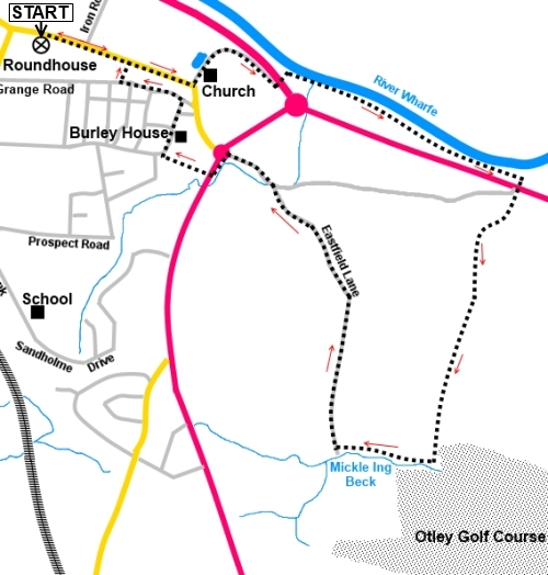
Start:
From the roundhouse in Burley’s park (SE 166464), turn right along Main
Street and continue walking to the bend at St Mary’s Church. Turn left
along Corn Mill Lane (SE 171463).
Note the plaque about the Pudding Tree in the circular stone bed at the
corner.
%20Pudding%20tree.jpg)
%20St%20Mary's%20Church%20Burley.jpg)
%20Mill%20Dam.jpg)
%20Footpath%20by%20Burley%20Hall.jpg)
Pass the dam and corn mill. Just past the
corn mill, the tarmac peters out. Follow the footpath down to the main road
and cross it to continue down the footpath opposite, marked with a public
footpath fingerpost, to the river.
At the river, turn right to follow its bank
to the end of the field and before entering the next, turn right through the
kissing gate (SE 180460). Cross the main road again, taking great care, as
this is a fast stretch and at the start of the old Otley Road, turn left on
the bend, again following a public footpath fingerpost. Almost immediately,
turn right over a stile to follow the yellow footpath arrow.
%20River%20Wharfe.jpg)
Climb the short banking and bear left to go
past the right hand corner of Laund House Farm and follow its boundary wall
anti-clockwise. Keep to the left hand side of the next two fields, passing
under some power lines.
%20Panorama%20Rombalds%20Moor.jpg)
%20View%20of%20Otley%20Chevin.jpg)
You reach Mickle Ing Beck, where a footbridge
crosses into Otley Golf Course. Do not cross but turn right to follow the
right hand side of the beck along the field (SE 178452).
Go through two metal gates. The last one
leads you into the broad track which is Eastfield Lane (SE 175452). Turn
right to follow Eastfield Lane down to the old Otley Road, passing Lowland
Farm and a number of houses, the last one being The Old Farm.
%20View%20North.jpg)
%20Edge%20of%20Burley%20with%20Moors%20behind.JPG)
At the road turn left to the roundabout. Turn
left and immediately cross to the ladder stile (which will be visible) and
over it into Burley House Field.
%20Stile%20Entry%20to%20Burley%20House%20Field.jpg)
Walk straight across Burley House Field,
leaving it via a kissing gate in the right hand corner. Note the remains of
the stone “ha-ha” which would have provided a barrier to prevent
livestock entering the grounds of Burley House, in years past, whilst being
invisible from the house side. Turn right along Langford Lane, passing the
high stone wall and the rear of Burley House.
%20Colourful%20Trees.jpg)
At the junction with Back Lane, turn left, to
return to the park and the roundhouse. However it is worth a short
diversion, after 200 yards or so, to see the garden of the Methodist Church,
by turning right through it (permitted access) then left along Main Street.
If you need to buy any
hiking equipment/clothing before your trip see the Hiking
Store
All information on this
site is given in good faith and no liability is accepted in respect of any
damage, loss or injury which might result from acting on it.
|


.jpg)
.jpg)
.jpg)