|
Burley-in-Wharfedale
to Ilkley and the Swastika Stone
|
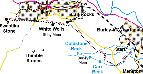
Starting
point and OS Grid reference:

Train station car park at Burley-in-Wharfedale (SE
164457)
|
Ordnance
Survey Map
OS Explorer 297 - Lower Wharfedale & Washburn Valley.
Buy this map from
List
of OS Maps
Note: If you use OS Maps on-line, you can download this route via this
link.
| |
Distance: 7.8
miles
| |
Traffic light rating:

(For explanation see My
Walks page)
| |


For advice on .gpx files see
My
Walks page
|

Click
the PDF logo above to give a printable version of this walk without the
photos.
|
To
view route as a dynamic Ordnance Survey map click here.
Introduction:
There is a common misconception that all the moors above Burley-in-Wharfedale
and Ilkley are “Ilkley Moor”, a belief no doubt encouraged by the “On
Ilkley Moor Baht ‘at” song. In fact the collective name is Rombalds Moor
and this easy walk crosses the Burley and Ilkley Moor sections of it. It is
a useful walk in that it can be accomplished by getting a train to Burley from Leeds or Bradford and
a return train from Ilkley afterwards. Buses are also available but if you
arrive in Burley by bus, you need to make your way up Station Road to the
train station where the walk starts. If you come by car, parking in the
vicinity of the station is limited and other than on a Saturday or Sunday,
the station car park will be full of commuters.
There are various choices for food and drink en route ranging from
the pub/hotel at the Cow and calf Hotel, a refreshment kiosk and multiple
choices in Ilkley itself.
I have chosen the scenic
route out of Burley but quicker ways to the moors are via Hag Farm Road
behind the station (picking up the walk at SE 159446) or simply straight up
Station Road (which becomes Moor Lane) (picking up the walk at SE 150451)
but my route is more interesting.
The path follow the edge of
the moor with good views across lower Wharfedale, takes in the famous Cow
and calf rocks, goes to White Wells, a bath house built by Squire Middleton
in the 18th century for the local people and finally the Swastika
Stone so named because of the ancient swastika type design on it. As far as
I know, no-one has ever deciphered what it means. The design closest to the
path is actually a Victorian copy of the fainter ancient original behind.
The bath house is open irregularly to the public but you will need
to check opening in advance if you want to see it.
Start:
Leave Burley-in-Wharfedale railway station via platform 2 (the platform
you arrive on from Leeds or Bradford) (SE
164457).Go straight across the car park and down the ginnel/snicket/alleyway
(depending on where you come from!) into Prospect Road. Turn right and first
right again into Rose Bank. Walk along Rose Bank and turn right after about
400 yards along here, into Heather Rise. As this road bends
to the right, keep straight on along the footpath between the gardens.
Do not go under the railway
bridge but instead as you approach it, climb the steep steps on the left (SE
165455). At the top, turn left along the disused railway line. Continue
until you pass (but ignore) a footpath on the left down some steps. The path
forks. Take the right fork and descend to a kissing gate then immediately
right through another. (Note the
former route directly across the field via a footbridge is no longer a
public footpath Right of Way).
Follow the path through the woods to the
railway embankment then left through another kissing gate, to follow the
course of the embankment (Note: the
former route which crossed the railway is now closed)
Follow the embankment to a cattle arch and
turn right under the railway, via two kissing gates. Follow the left hand
boundary of the field, ignoring a stile on the left.
At the corner of the field, go through
another kissing gate and again, follow the left hand boundary of the field,
passing the ruins of an old building.
Cross a two plank footbridge over a stream
and follow the left hand boundary and the course of the stream.
Continuing following the left hand boundary
of subsequent fields until you arrive at the second squeeze stile, where you
exit into a broader track. There is a post with various yellow footpath
arrows (SE 159446).
Go
straight on here.
%20Three%20stoned%20stile.jpg)
%20Old%20Mill%20Chimney.jpg)
Continue following the
course of the beck ignoring any turns left or right and go through an
unusual three stoned stile. Follow the footpath until you come to a group of
cottages, cross the beck once again via the stile and bridge and go up the
drive between the houses. The drive exits into the road (SE 156444). Take
great care here as there are blind bends and speeding cars. Cross the road
and follow the track immediately opposite.
Remain on this main track
ignoring any turns off as it rises to the open moors and after crossing the
cattle grid, turn right and follow the broad track (SE 149447). You pass in
front of a large stone house bearing the date 1861 and an old quarry on the
left. The track descends gently to another farm at which point you come to
another well used footpath on the left and start to ascend it (SE 150451).
At a fork, keep right then ignore the immediate right turn and continue
climbing gently.
%20View%20towards%20burley-in-Wharfedale.jpg)
At the next junction, turn
right heading to the valley/ravine with the stream at the bottom (Coldstone
Beck). Cross the stream and climb the other side and stay on the left of the
stone wall. Stay on the main path as it follows the edge of the moors until
you reach the unmistakable Cow and Calf Rocks.
Avoid the obvious tracks
going down to the road.
As you pass above the Cow
and Calf Hotel, look out for the large rocks on the right which is where the
Cow and Calf Rocks are (SE 130467). There is a right fork here which you may
wish to use to get a closer look at the rocks. There is a kiosk below where
refreshments can be obtained. Return to this fork and turn right passing
behind the old quarry area behind the rocks.
%20Cow%20and%20Calf%20Rocks.jpg)
%20Old%20quarry.jpg)
Another old quarry appears
with a copse of fir trees growing in it. Walk round the back of this old
quarry. You come to a small valley on the left with a stream and part way
down this, just after passing an outcrop of rocks, descend the steep footpath to
the stream and up the other side heading for another copse of trees ahead.
As you enter the copse of
trees, you will see the white buildings of White Wells ahead which is your
next destination. Go straight ahead through the trees.
%20View%20towards%20Ilkley.jpg)
%20View%20to%20White%20Wells.jpg)
It is now a case of heading
towards White Wells via whatever is the easiest path. I say this because in
the summer, the bracken grows quite high and picking out any path in
particular can be difficult. The one I used started off curving right then
swinging left but as long as you keep heading roughly in the direction of
the buildings, you will get there eventually, probably passing a tarn (which
may be a mass of reeds in summer) with a wooden post with “F20” written
on it.
%20White%20Wells.jpg)
At White Wells (SE 118468),
refreshments may be available and there are picnic tables. It is usually
open at weekends 2pm - 5pm
during school holidays, particularly the summer holidays and flies flags to
indicate when it is open. A limited facility public toilet is situated in
the small separate white building. When White Wells is open, it is worth
having a look at the old public bath through the doorway next to the cottage
(signed).
Walk across the front of White Wells and
follow the main track
downhill. After crossing a cobbled ford and turning the
corner, take the footpath on the left (SE 116468). At a fork, take the right
fork.
On reaching the tarmac
road, turn left. After about 150 yards, turn right on to a footpath
indicated by a green fingerpost. Follow this broad footpath as it passes
along the rear boundary of houses. You pass a reservoir.
Go over a footbridge
crossing Hebers Ghyll where there is a finger post indicating it. Ignore
this and carry straight on to see the Swastika Stone but remember it as this
is your eventual way into Ilkley.
Go through a metal gate and
ignore the steeply descending path to the right, go straight across the dip
and where the path forks go left and follow this round to the Swastika Stone
which is inside the railed enclosure which you can see ahead
(SE 096470).
%20View%20at%20Swastika%20Stone.jpg)
%20Swastika%20Stone.jpg)
After seeing the Swastika
Stone, retrace your steps to the Hebers Ghyll finger post (SE 099469) and
follow it down. By a bench in a walled enclosure, turn right and follow the
path down the ghyll over a series of bridges, ignoring any minor turns off
here and there.
The path exits into Hebers
Ghyll Drive. Turn right and follow this along to Grove Road. Go right on
Grove Road which becomes The Grove, the main shopping street through Ilkley.
Walk along here and across the roundabout to reach the bus/train stations.
Note 1 Railtrack
are intending to close this footpath route across the railway. At the time
of writing, (December 2018) no date is set but it might have happened by the
time you do this walk. See
this diagram. The path C to F in black will close and be replaced by the
green route C – I –G - F which goes under a stone arch beneath the
railway at I.
If you need to buy any hiking
equipment/clothing before your trip see the Hiking
Store
All information on this
site is given in good faith and no liability is accepted in respect of any
damage, loss or injury which might result from acting on it.
|


.jpg)
.jpg)
.jpg)