
|
|
|
To view route as a dynamic Ordnance Survey map click here. Introduction: This straightforward walk takes you from the up market village of East Keswick to Harewood, home of the famous Harewood House. The route travels along the banks of the River Wharfe, where you get views along the valley to Almscliff Crag, through an attractive stretch of woodland on the Harewood Estate and back along part of the Leeds Country Way which, at a slightly elevated level, provides good views over the valley to the North. Unfortunately, my day was one of grey cloud with only odd sunny spells so views and sadly the photos, were rather muted. East
Keswick is around four miles south-west of Wetherby and is a conservation
area. The name ‘Keswick’ is believed to have come from Old English words
cēse, meaning cheese and wīc, meaning specialised
farm. So the conclusion is that there was a cheese farm. ‘East’ seems to
have been added at some point as a distinguishing feature. An agricultural
estate features in the Domesday Book. Edwin Lascelles (one of the Earl
of Harewood ancestors) bought the estate in 1739 but the family had to sell
it to pay off death duties in 1950 and existing tenant farmers were able to
buy. The area is very much still agricultural although the village itself is
home to many affluent residents, who earn their money by other means. Harewood is a much smaller village
and home to Harewood House, a country house with a vast acreage which is
open to the public. The village’s existence was originally as home to
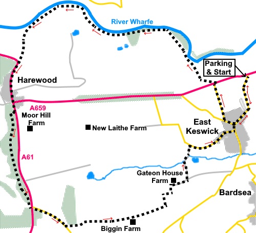
those who serviced the Harewood Estate and probably still is. The walk starts at a free car park
at the junction of Crabtree Lane and the A659, one and a half miles west of
its junction with the A58. It is signposted for East Keswick. This is the
best direction to approach for ease of finding it, as from the west, there
are three other roads leading to East Keswick. There are some picnic tables
to help identify the spot. The walk initially follows part of
the Ebor Way. This is shown on the OS map as along the A659, from the start
of the walk. However, this is a very fast, busy road and the verges are very
narrow. I felt it would be foolhardy in the extreme to walk along this
stretch of road and I therefore began the walk by walking up into the
village and looping round down to one of the other roads which link the
village to the A659. It is then only necessary to cross it and head straight
down to the river. This might make the walk three quarters of a mile longer
than it would otherwise be but on the other hand, I am still here! Start: Walk away from the A659, up Crabtree Lane (SE 363454) into the village. Turn right along Lumby Lane, the first ‘proper’ junction you come to other than side roads to houses.
After about a hundred yards, turn right again along Cleavesty Lane (SE 359446). This takes you down to the A659. Turn right briefly along the wide verge for only fifty yards or so and carefully cross the road to follow a public footpath fingerpost.
Follow the path down to the river and follow its bank west.
The path is pretty clear but at
one point you enter wide grassy stretch with neatly planted willow on the
left. Turn right here to walk closer to the river bank. The turn is marked
by a yellow topped post with arrows (SE 346462). You now follow the river bank for one and a half miles.
Reach another indicator post (SE
325463). Turn left on what is more or less a green lane between two rows of
hedging. Follow this path up to the A61 and
turn left. There is a pavement. When this peters out, cross carefully, as
this is another busy, fast road and follow the opposite pavement. Continue
along the road passing a memorial garden where there are some benches where
you could have a picnic, if you do not mind the traffic noise.
Alternatively, the Harewood Arms is just across the road!
Walk past the grand entrance to
Harewood House and there is a point to make about the OS map. The route
follows a permissive path through the woods on the Harewood Estate. It is
marked in brown dashes on the map. At the time of writing, this is shown as
running from the main driveway to the House. However, it seems to have
altered and you now should continue along the main road. Look out for a gate
on the right, next to an old stone house, marked with a sign for “The
Wallside Permissive Path”. Go through this gate (SE 322448) and follow the path to a fence. Keep left of this and join the broad track through the woods, by turning turn left.
Follow the track for a mile, until
you reach another broad track at a ‘T’ junction, where you join the
Leeds Country Way (SE 325431). Turn left. Cross the A61 again and head down the road opposite, signposted for “Wike 1 mile”. Follow it for less than half a mile and look out for a fingerpost on the left, indicating a bridleway, just before the thirty mph speed limit signs. Follow this clear path, passing Biggin Farm, and avoiding any footpath off to the side. At the end of a long field, meet a broad track at a ‘T’ junction. There is a sign on the gatepost which says “Horses must keep to the bridleway”. Turn left there, following the Leeds Country Way fingerpost. It is a clear track and there are plenty of private/keep out signs to stop you going wrong! Pass Gateon House Farm.
Pass the end of a ‘loudly’
marked private lane and within a few yards, turn left following the public
bridleway fingerpost and leaving the Leeds Country Way (SE 352436). At the road, turn right to take you into East Keswick, then left at the main street to return to the car park.
If you need to buy any hiking equipment/clothing before your trip see the Hiking Store All information on this site is given in good faith and no liability is accepted in respect of any damage, loss or injury which might result from acting on it.
| | |||||||||||||||||

.jpg)
.jpg)
.jpg)
%20Vew%20East%20ascending%20Crabtree%20Lane.jpg)
%20View%20north%20just%20after%20crossing%20the%20A659.jpg)
%20River%20Wharfe.jpg)
%20View%20west%20along%20the%20valley%20to%20Almscliff%20Crag.jpg)
%20View%20east%20on%20joining%20the%20A61.jpg)
%20Track%20through%20the%20woodland%20on%20the%20Harewood%20Estate.jpg)
%20Autumn%20colours%20on%20the%20Harewood%20Estate.jpg)
%20View%20over%20the%20Harewood%20Estate.jpg)
%20View%20from%20the%20Leeds%20Country%20Way.jpg)
%20East%20Keswick.jpg)