
|
|
|
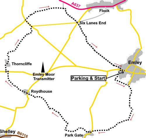
To view route as a dynamic Ordnance Survey map click here. Introduction: Emley is in a sort of ‘no man’s land’ in the triangle formed by Huddersfield, Wakefield and Barnsley and this walk, suggested by a friend of mine, was born out of curiosity as to the area. It is of course most famous due to proximity to the mast for the Emley Moor Transmitting Station from which most of the television in Yorkshire comes. Indeed I have lost count of the number of times I have seen this mast in the distance during my walks. Strictly speaking, the correct name for the mast is the Arqiva Tower, after the company which owns and operates it but I have never heard anyone refer to it in that way. The mast is said to be the tallest freestanding structure in the UK at 1084ft, a foot taller than the Eiffel Tower. It was constructed in 1971 after the original metal mast was felled by the weight of ice in the winter of 1969. The mast dominates the skyline from many vantage points in Yorkshire and certainly on this walk, always on your right. If you find it on your left whilst following this route, you have gone seriously wrong! The village of Emley dates from Anglo-Saxon times. The name comes from the name ‘Em(m)a’ or ‘Eama’ and ‘lēah’ meaning a wood or woodland clearing, though was recorded in the Domesday book as ‘Amalie’ and ‘Amelia’. In the past iron ore and coal mining were important industries. Farming was and still is important in the area. In 1253 King Henry II awarded a Royal Charter to Emley, hence the market cross (or what remains of it). This walk offers some pleasant long distance countryside views and, if you happen to be doing it at the right time of year, take a container to collect blackberries. Genuinely, I have never seen so many during a walk. Overall, this is an easy walk with little gradient. The walk starts from a car park close to the stump of the market cross, opposite the end of Church Street. There are so many permutations of ways to get there, depending on where you are coming from, refer to a map or use sat.nav. Start: Turn left out of the car park and at the white painted market cross, turn right along the road then soon left along Tyburn Lane.
At the end of Tyburn Lane, follow the footpath. After a hundred and fifty yards or so, turn left over a stile.
About a quarter of a way along the field, there is a path off to the left but ignore this and continue to follow the left hand boundary when the clear path peters out
As you get to the corner of the field, ignore the path forking left over a stile with a post and way marker. Instead, turn right down the broad track. The track bends sharply right to a property but carry straight on down the grassy track to a farm gate. Turn right here. At the bottom of the field, cross a stile and head for the far left hand corner of the next field. As you get to the corner, cross over the dilapidated wall and turn immediately right to a stile. Cross this and follow the right hand boundary for a short distance to a broad track and turn left (SE 245121). After a hundred and fifty yards or so, turn right on to a footpath.
After going through a gate, head for the far side of the field, about a third of the way from the right hand corner. Go through a walkers’ gate and follow the left hand boundary. Follow the field boundary as it curves left and turn left at the corner. A short distance takes you to the broad access track to the farm (Blacker Farm) where you turn right. Follow this track to the road where you turn left at Park Gate. Look out for a public footpath sign on the left hand side but pointing right. Turn right along what begins as a drive to the houses before becoming a stony track/footpath. You will pass a left turn over a footbridge but ignore this and continue along the main path until it exits over a stile into a broad track. Turn right. You will reach an impressive set of gates blocking the way but there is a walkers’ gate to their right hand side to maintain access to the Right of Way. When you reach a junction keep left (SE 227116). The track soon bends right to the property but keep straight ahead over a stile, then keeping to the right hand boundary in this field and the next. After entering the third field, quickly bear left at about 45° to the trees. When you reach the wall, follow it as it curves left. As the wall ends, cross a double stile then turn right following the curve of the field, ignoring the first path off to the right. Cross the next stile which involves crossing a plank bridge. In the field after the bridge, the path curves left in an arc to the farm (Wool Row Farm). The map here is a little misleading as it suggests you join a wide track. However, when you get to the edge of the field at the farm, turn right up the side of the field. You will soon come to a stile on the left. Cross
the stile and go straight across the field to the house you can see. The
Right of Way passes the front of the garage to reach the road where you turn
right.
Immediately before the Three Acres Inn, turn left along a no through road and continue passing Hillcrest Farm and follow the obvious track after the cottages. When it divides, fork right over a stile and head to about a quarter of the way (from the right) along the far side of the field Follow the left hand boundary of the next and subsequent field until you reach the road where you turn right for a few yards. Turn left up a broad drive indicated by a public footpath fingerpost on a lamp post The Right of Way bends left at the houses then right at a junction to pass to the right of the property Thornycroft. When the track opens into a field, turn right and follow the right hand boundary. At the top of the field, turn left to follow the wall. The route of the footpath is now clear, to the right of the trees and also to the right of the houses ahead, where a fenced section takes you to the road. Turn left along the road for about three hundred yards. It is quite busy with traffic but there is a narrow grass verge.
Keep a look out for Rose Cottage (Number 5) on the left and just and opposite this, turn right following a public footpath fingerpost. The next stile is visible ahead, where you continue in the same direction to emerge in a lane at Near Cockermouth Farm. Turn right for a few yards, then left over a stile following a public footpath fingerpost. Follow the direction of the arrow and it leads to a walkers’ gate. Through that, follow the right hand boundary. The path exits into the access drive to the farm and the route is more or less straight ahead, following the left hand boundary of the fields but switches to the other side just before reaching a cottage with a cream rendered gable wall.
Turn right immediately by the gable end of the cottage. The path emerges at a broad track. Turn right. You arrive at the aptly named Six Lane Ends. Go straight over the junction and along the track Crawshaw Lane. At a crossroads of tracks, continue straight ahead and keep following the track until it emerges at the end of a cul de sac road. Follow this uphill to the junction where you turn left to return to the car park. If you need to buy any hiking equipment/clothing before your trip see the Hiking Store All information on this site is given in good faith and no liability is accepted in respect of any damage, loss or injury which might result from acting on it.
| | |||||||||||||||||

.jpg)
.jpg)
.jpg)
%20Stump%20of%20the%20old%20market%20cross%20in%20Emley.jpg)
%20First%20sight%20of%20the%20Emmley%20Moor%20mast.jpg)
%20Emley%20Moor%20mast%20again.jpg)
%20View%20towards%20Clayton%20West.jpg)
%20View%20towards%20Skelmanthorpe%20and%20Shelley.jpg)
%20Countryside%20View.jpg)
%20View%20over%20Calderdale.jpg)
%20View%20over%20Calderdale.jpg)
%20View%20towards%20Huddersfield.%20Victoria%20Tower%20just%20visible..jpg)
%20Buckwheat%20anmd%20Emley%20Moor%20mast.jpg)
%20Pleasant%20view.jpg)