|
Ilkley
to Addingham Via Dean Beck
|
Starting
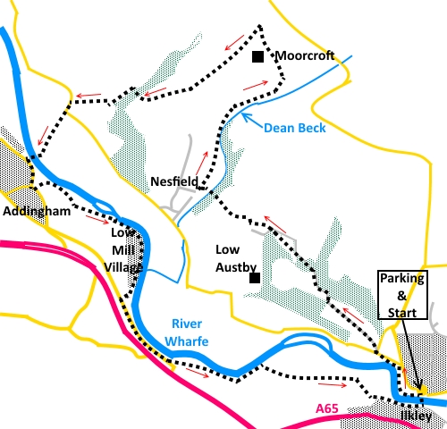
point and OS Grid reference:

Free
roadside parking on Denton Road, Ilkley (SE 112482)
|
Ordnance
Survey Map
OS Explorer 297 Lower Wharfedale & Washburn Valley.
Buy this map from
List
of OS Maps
Note: If you use OS Maps on-line, you can download this route via this
link.
| |
Distance: 6.5
miles
|
Date of Walk: 20
August 2014
| |
Traffic light rating:
 but see *
in text
but see *
in text
(For explanation see My
Walks page)
| |


For advice on .gpx files see
My
Walks page
|

Click
the PDF logo above to give a printable version of this walk without the
photos.
|
To
view route as a dynamic Ordnance Survey map click here.
Introduction:
This walk from Ilkley to Addingham is
something of a dog-leg route, which starts in West Yorkshire but wanders back and forth
across the boundary with North Yorkshire. This was to create a more
interesting route than walking along what might seem the straightforward
lane route and also to visit some of the surprisingly fine viewpoints along
the way. I say surprising because although the overall climb is no more than
about 600ft, the views to the Yorkshire Dales, Beamsley
Beacon and over the Wharfe Valley to Rombalds Moor are well worth the
trip.
The lane, mentioned above, is variously named
Nessfield Road, Common Holme Lane, Gill Lane and West Hall Lane (to name but
a few) at different sections along its length. It is narrow but fairly well
used by motorists, cutting off a corner to/from the A59, which can make for
unpleasant walking. It is also a cycle route.
*
There is one tricky section of steep and
usually muddy descent, during the walk, to Dean Beck. It is short and there
are small trees and branches to provide some handholds but you have to be
prepared for a slip and a muddy bum – that’s the bottom line! Once over
Dean Beck, depending on the time of year, bracken can mask the route but a
little determination, at right angles to the beck, will get you quickly to a
broad track.
There are
refreshment opportunities at various establishments in Addingham. My
personal favourite is The Crown pub.
The walk starts from the old stone bridge at
Ilkley. To get there, turn north, away from the town centre, at the main
traffic lights in Ilkley, signposted “Middleton”. Cross the river then
turn first left, along Denton Road. Park as near to the traffic island by
the old stone bridge as you can.
Start:
Walk along Denton Road and at the old bridge, by the traffic island, take
the footpath along the right hand (north) riverbank, following the public
footpath fingerpost. It comes out on to Nesfield Road by Ilkley Golf course.
Cross straight over and turn left along the no through road, Owler Park
Road.
%20Old%20Stone%20Bridge%20Ilkley.jpg)
Continue to follow Owler Park Road for just
over half a mile turning right past Austby (on gateposts), then left. There
are then two more gentle bends, first right, then left. At the next fairly
gentle right hand bend, look out for a stile on the left marked by a yellow
footpath arrow (NB in July 2020, it was reported to me that this yellow
arrow was missing. If you happen to see it replaced, I would appreciate it
if you could let me know). The stile is just before a house on the right called Friars
Hill.
Cross the stile and head up the field to the
diagonally opposite corner, coming out by High Austby Cottage – there is a
stone sign for the cottage with the footpath route to the right
indicated. Take the lane to the right of the cottage.
Around this junction were signs warning of a
steep hill and unbridged stream ahead and giving an alternative route to
Gill Lane. However, Gill Lane is the route I was specifically trying to
avoid, so I pressed on!
Go straight across the farmyard at High
Austby Farm and take the walled track. Views to the left over Rombalds Moor
start to open up.
%20View%20to%20Addingham.jpg)
The track ends at a somewhat rickety old
barn. Go straight ahead through the metal gate. There is a white arrow
indicating the footpath. Keep to
the right hand boundary of the field. There are views over Addingham ahead.
Go through the gate at the end of the field.
The path now descends the very awkward slope mentioned above, to Dean Beck.
Cross Dean Beck as best you can. There had
been some heavy rain a day or two before I did this walk but the stream flow
was small, with plenty of stones and crossing was easy. Unfortunately, it
being summer, bracken was in full growth and there was no sign of the path
up the opposite bank. If there was an arrow, I missed it. It was therefore a
case of fighting through the bracken. If you have similar problems finding
the path, keep ahead, at right angles to the beck, and you will soon come to
a broad track. Turn right here.
In less than 100 yards, you will catch sight
of the house through the trees, to which the track leads. Before you get to
the house, look out for a path off to the left, indicated by a yellow arrow
on a tree (easy to miss).
%20View%20down%20Dean%20Beck.jpg)
The path follows the course of Dean Beck,
though at a higher level, climbing gradually, coming out at a stone built
farmhouse. Turn left briefly along the drive, before going over a stile on
to open land. Pass under power lines.
Initially, follow the direction of stone wall
on the left but when it turns left, strike out across the open ground. The
path is clear and you are virtually heading towards the hill of Beamsley
Beacon, on the horizon.
%20Beamsley%20Beacon.jpg)
Cross a tarmac drive (leading to Moorcroft)
keeping in line with the boundary of the property and turn left to follow
the grassy track between two walls. Along here are great views to the right,
towards the Yorkshire Dales. The prominent hills closest to you are Sharp
Haw and Rough Haw.
%20View%20towards%20Yorkshire%20dales.jpg)
%20View%20towards%20Ilkley%20Moor.jpg)
Go through a gate and Addingham is visible
ahead. Keep to the left hand boundary of the field and after going through
the next gate in the corner, descend the walled green lane. Watch for the
point where the track starts to narrow and cross the stone slit-stile on the
right, with a two way fingerpost, each “finger” just saying “Public
Footpath” (NB in July 2020, it was
reported to me that this fingerpost was missing. If you happen to see it
replaced, I would appreciate it if you could let me know). Take the route ahead, not the one to the right.
Follow the wall to a corner and from here,
head diagonally down the field towards the trees. There is nothing specific
to aim for at this point. If you have a compass, around 295° magnetic will
get you to about the right spot at the trees, which is about one third of
the way along the opposite side of the field, from the bottom. Once you get
to the trees, there is a spot to cross the stream where it disappears
underground and a gate (SE 091504).
Go through the gate and turn left to follow
the left hand field boundary. Go through a slit stile at the bottom of the
field and head for the diagonally opposite corner, where there is another
stile on to the lane.
Turn left at the lane for a few yards and at
the small traffic island, keep straight ahead on the No Through Road
signposted “Footpath to Addingham”.
Just before you get to the farm buildings, turn right through a
walkers’ gate and follow the obvious path to the suspension bridge over
the Wharfe and climb the steps to the road (ignore the footpath off right).
%20Addingham%20Suspension%20Bridge.jpg)
At the road (Bark Lane), turn left. If you
want to avail yourself of the refreshment opportunities in Addingham, turn
right along Church Street. Otherwise, continue along Bark Lane, following
the signs for The Dalesway.
Come to another sign for the Dalesway and
turn left by Bridge Cottage, going over an ancient packhorse bridge. Once
over this, ignore the tarmac path going to the churchyard of St Peter’s
church but fork off right to follow the path across the grass to its right.
%20Old%20packhorse%20bridge%20Addingham.jpg)
%20St%20Peters%20church%20Addingham.jpg)
%20Weir%20at%20Addingham.jpg)
Arrive at another small packhorse bridge.
Cross it and climb the steps to a lane and turn left. Follow the lane to its
end and and over a ramp/step arrangement into Low Mill Village. This is a
refurbished settlement of old mill workers cottages, originally built in the
18th & 19th centuries. The mill building itself
has been converted into apartments, with (in my view) an incredibly ugly
modern top floor. Walk through the “village”, passing the weir. Continue
to the ‘T’ junction and turn left.
The road you are now on is the old main A65.
This runs parallel with the new road so there is some traffic noise. From
the ‘T’ junction, walk for just over a third of a mile and at a gentle
right hand bend, from where you can see the junction with the current A65,
turn left following the fingerpost for “The Dalesway” and “Ilkley”.
Turn left over a footbridge to stay on the
riverside path to Ilkley Tennis Club, where you turn right along the drive.
At the ‘T’ junction go straight ahead on the obvious wide footpath. This
comes out at the old river bridge. Cross it to return to your car.
%20Approaching%20the%20Old%20Stone%20Bridge%20at%20Ilkely.jpg)
%20Heron%20at%20Ilkely.JPG)
If you need to buy any
hiking equipment/clothing before your trip see the Hiking
Store
All information on this
site is given in good faith and no liability is accepted in respect of any
damage, loss or injury which might result from acting on it.
|


.jpg)
.jpg)
.jpg)