
|
|
|
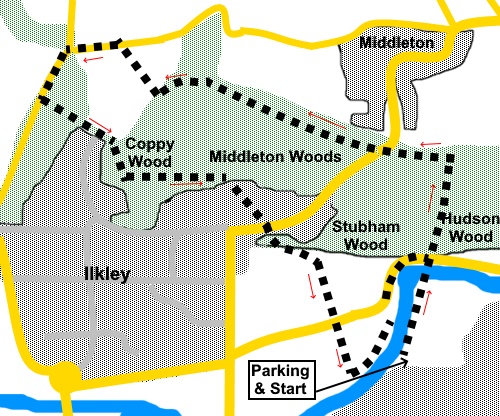
To view route as a dynamic Ordnance Survey map click here. Introduction: This is a short walk and my reason for the visit was simply to see the bluebells. They were truly a magnificent extensive display in 2021 but are renowned for a good performance most years. The walk also passes through a more open field from which there are great panoramic views over Ilkley and to Rombalds Moor. As with many woodland walks, there tend to be paths all over the place, so a precise route description is difficult in parts. I did have problems with my GPS receiver under the tree canopy but quite honestly a missed path or short extra distances hardly mattered when wandering amongst the blooms. Looking at the OS map, “Middleton Woods” is something of a catch all for several woods; Middleton Woods themselves, Coppy Wood, Stubham Wood and Hudson Wood. However, woodland has been here since at least 1600 and so earns the title of Ancient Semi-Natural Woodland (ASNW), an honour which only applies to 1.2% of all British woodland. It is the largest remaining ancient woodland in West Yorkshire. In addition to bluebells, wild garlic and wood anemones were in evidence. There were also a variety of birds judging from the birdsong although I only saw a jay. Many people start the walk from a rough lay-by on the Denton Road but this quickly fills at bluebell time so I chose to park at the other side of the river on Beanlands Parade, which is quieter and cross via the footbridge. To get there, turn north off the A65 down Ash Street or Leamington Road, both of which lead to Beanlands Parade. Start: Walk west along Beanlands Parade to the river Wharfe then turn right to walk along the riverbank to the footbridge. Cross then cross the road and through the kissing gate into the woods.
When the path splits, keep right. It is worth saying here that there are a number of options but broadly speaking, as long as you continue uphill, you are likely to end up in the right place.
The path divides again fairly quickly. Keep left on the more steeply rising path.
Cross a much broader path and continue uphill. At the next split, which is virtually a ‘T’ junction, go left. If you have managed to follow my description, you will pass a post marked ‘E4’. Houses come into view on the right. Continue on what becomes a broad track, soon starting to follow a moss covered wall on the left.
Follow this to the road (Curly Hill) (SE 121489). Cross and take the obvious path through the trees straight ahead. This soon divides by a bench. Take the right hand track. Continuing following the broad, clear track, which is fairly close to the upper edge of the woods. At SE 119488, pass a spring with a stone structure.
Continue to follow this track until at the top of a short banking, you cross a stile into a field (SE 115490). There are good views here over Ilkley and to Rombalds Moor. Cross the field to the opposite corner and go through a kissing gate to the road. Turn left.
At the road junction, turn left and continue downhill for about three hundred yards, passing Myddleton Grange.
Look out for a fingerpost on the left marked by a fingerpost and return into the woods (SE 112490). Follow the obvious path through the trees until you get to the edge of a small valley with a pretty stream. Turn left (marked by a yellow arrow) to a bridge and cross the stream. The path then turns right.
It climbs to a field. Cross the stile and follow the right hand boundary of the field (this is actually the lower part of the field you crossed before). Ignore a path about half way along and at the corner, cross a stile back into the woods once again. After a few yards, join another path and turn right.
The path is now obvious crossing a number of low bridges. After crossing a long one, the path splits. Take the right hand fork. Descend a lot of rough steps to the road. Turn left then right within a few yards to follow the direction of a public footpath fingerpost. You enter the complex where Ilkley swimming pool/lido are. Skirt this clockwise and just before the tarmac track turns right to the exit, head for the left hand corner of the field and through the gap. Cross the road and go through another gap into East Homes Field. Continue in the same direction to the river, then left back to the footbridge.
If you need to buy any hiking equipment/clothing before your trip see the Hiking Store All information on this site is given in good faith and no liability is accepted in respect of any damage, loss or injury which might result from acting on it.
| | |||||||||||||||||

.jpg)
.jpg)
.jpg)
%20Footbridge%20over%20river%20Wharfe.jpg)
%20View%20along%20Wharfe%20from%20footbridge.jpg)
%20Bluebells%20in%20Middleton%20Woods.jpg)
%20Bluebells%20in%20Middleton%20Woods.jpg)
%20Bluebells%20in%20Middleton%20Woods.jpg)
%20Bluebells%20and%20mossy%20wall.jpg)
%20Spring%20in%20Middleton%20Woods.jpg)
%20Rocky%20outcrop%20with%20bluebells.jpg)
%20View%20to%20Rombalds%20Moor.jpg)
%20Outside%20Myddleton%20Grange.jpg)
%20Footbridge%20in%20Middleton%20Woods.jpg)
%20Fallen%20trees%20in%20Middleton%20Woods.jpg)
%20Footpath%20through%20the%20bluebells.jpg)
%20Blossonm%20in%20East%20Holmes%20fiels.jpg)
%20Rapids%20on%20the%20Wharfe.jpg)