|
Otley
Chevin (Surprise View)
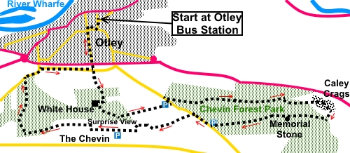
Starting point and OS Grid reference:

Otley
Bus Station (SE 203455) – see text regarding parking
|
Ordnance Survey Map
OS
297 Lower Wharfedale and Washburn Valley.
Buy this map from
List
of OS Maps
Note: If you use OS Maps on-line, you can download this route via this
link.
| |
Distance:
6.4
miles
|
Date of Walk:
2
January 2015
| |
Ascent:
Descent:
See Walking Time Calculator
|
1178ft (359m)
1179ft (359m)
| |
Traffic
light rating: 
(For explanation see My
Walks page)
| |


For advice on .gpx files see
My Walks page
|

Click
the PDF logo above to give a printable version of this walk without the
photos.
|
To
view route as a dynamic Ordnance Survey map click here.
Introduction:
This walk from Otley
to Otley Chevin is an easy walk which would be ideally suited to anyone
wanting to dip a toe into the world of walking for the first time. It is
also a good walk for children as there are lots of interesting things to see
along the way. The route passes through the Chevin Forest Park where there
are lots of information boards about the area generally and specific points
of interest. There are also a number of interesting wooden sculptures, many
of which will appeal to children. These are very pleasant woodlands, through
which to stroll.
There are fine vistas of
Lower Wharfedale at various points.
The walk passes Caley
Crags, a series of gritstone boulders popular with climbers and a spot where
the famous artist J.M.W. Turner came to paint views of Farnley Hall, which
was owned by his friends the Fawkes family. Some of the original tree
planting on Otley Chevin was carried out by the Fawkes family in the 1780s.
Descendents of the Fawkes gifted the Chevin to the people of Otley in the
1940s.
After Caley Crags, the walk
circles round to visit the top of the Chevin known as Surprise View.
“Chevin” comes from Celtic word(s) meaning ridge. Here, there are some
more interesting rocks and great views of Lower Wharfedale over Otley and
across to Almscliffe
Crag. This is a popular spot for visitors and has a
large car park.
Through the car park at
Surprise view you can access The Royalty pub for food/drink.
The walk ends with a gentle
downhill through pleasant woodland.
Being a popular area, there
are many paths, both official and unofficial. This is not a problem in that
you can wander where you want but it can make it easy to go wrong. I cannot
claim my directions are foolproof but I have done my best! GPS receivers may
not be accurate when trees are in leaf.
I have started the
directions for this walk at Otley bus station for the sake of uniformity and
the benefit of those arriving by bus. If coming by car, there are various
car parks in Otley. Some are free but unless you arrive very early, these
are certain to be full. Beware the Otley traffic wardens are red hot! You
might be lucky and get a space at the very top of Station Road.
The other reason I start in
Otley is that it means all the climbing is virtually done at the outset,
rather than potentially at the end, depending on where else you start.
There are some car parks on
the route and as this is a circular route, you could use one of these. I
have marked them on the sketch map. However, with the possible exception of
the one at Surprise View, which tends to self police by reason of being
quite busy, others have a reputation for car break-ins and I would not leave
my car in any of them, unless I expected there to be a lot of people about
through the day (e.g. weekends, Bank Holidays etc.).
For an alternative route to Otley Chevin, see
Burley-in-Wharfedale
to Otley Chevin.
Start:
Turn right out of the bus station and right again at the junction with
Bondgate. At the corner by the church, turn left along Station Road. This
becomes cobbled after 100 yards or so.
Follow Station Road to the
top then cross the footbridge over the A660 (SE 203450). Once over the
bridge, a short section of walled/fenced footpath brings you to a road
(Birdcage Walk). Go straight across this, to take the footpath immediately
opposite, following the fingerpost for “Yorkgate”.
On arriving at an entrance
to Chevin Forest Park, go straight on up the cobbled path. You soon arrive
at the White House (on the right) (SE 203445), the HQ for Chevin Forest
Park, a visitors’ centre, café and toilets. Even if you do not want to
make use of the facilities here, it is worth venturing on to the terrace to
admire the view.
%20Cobbled%20path%20near%20start.jpg)
%20The%20White%20House.jpg)
%20View%20from%20the%20White%20House.jpg)
Return to the path you were
on and continue up through the trees. At the next section of steps, after
only a few yards, branch off left.
%20Sculpture%20marking%20turn.jpg)
At the next fork in the
path where there is a sculpture (see photo) and a sign warning of unsafe
passage for wheelchairs, branch off on to the broad path obviously
“manicured” with a base of small stones/quarry waste, to make it
accessible for wheelchairs etc. You soon pass a picnic table and at the next
fork, keep straight ahead, avoiding the descending path.
%20Panoramic%20view%20over%20Wharfedale.jpg)
You start to pass some
impressive crags (SE 207444).
%20Rocks%20at%20East%20Chevin%20Quarry.jpg)
On arriving at East Chevin
Quarry Car Park (SE 212445), exit to the road and turn left. Walk along the
road (there is a footpath) for less than 100 yards, then turn right by an
old millstone following the bridleway for Chevin Forest Park (SE 211446).
%20Sculpture%20at%20East%20Chevin%20Quarry%20car%20park.jpg)
You pass a sign confirming
you are at Danefield Wood and shortly another for Foxscar Wood. Pass and
ignore a permissive bridleway on the right.
%20Water%20trough%20and%20trees.jpg)
At SE 219446, you pass
through the site of an Iron Age settlement. There is an extensive
information board to tell you about it and it is a Scheduled Ancient
Monument.
Ignore a path to the left
for “Leeds Road” and stay on the main track.
Pass the large boulders of
Caley Crags, then take the climbing path to the right when the path splits.
Follow the public bridleway sign and ignore the left path signed for
“Leeds Road”.
%20Rocks%20at%20Caley%20Crags.jpg)
%20Rocks%20at%20Caley%20Crags.jpg)
%20Footpath%20by%20Caley%20Crags.jpg)
On joining a broad track
marked as the Ebor Way, turn left. You pass a sign for Keepers Wood and
soon, an information board about Caley Woods and Keepers Cottage. A few
yards after this, go through a kissing gate continuing straight ahead on the
Ebor Way.
You reach a superb
viewpoint (SE 231444) with a seat and an information board about the artist
J.M.W. Turner coming to this spot in 1808 to paint the view. His friend
Walter Fawkes owned Farnley Hall, the imposing house you can make out across
the valley.
%20Panorama%20to%20Beamsley%20Beacon.jpg)
%20View%20to%20Almscliffe%20Crag.jpg)
You now go a short distance
ahead and turn right on to a track, before
going under the power lines. Follow it to the kissing gate and through this,
turn right following the “Dales Way Link”.
You follow this clear main
track for almost a mile, keeping straight ahead at a junction, continuing to
follow a sign for the Dales Way Link and arriving at a car park by the road.
Along the way are a series of chainsaw sculptures, which children in
particular will find interesting. At SE 225444 there is a memorial stone
commemorating the services of 3 individuals for their services to “God,
their country, their county, this valley and township”.
%20Selection%20of%20Sculptures.jpg)
At the road, opposite the
car park, the Cheerful Chilli & Tea Room may provide a refreshment stop.
Otherwise, turn right down the road, again following the “Dales Way
Link” fingerpost. Take care here as this is quite a busy road and at the
start there is no footpath.
Go down the road for about
250 yards, then turn left along a broad track by Danefield House, following
the fingerpost for “Miller Lane” (SE 215444). When the track splits, go
right, through the gate for Chevin Forest Park – Miller Lane Gate.
Once through this gate, for
the best views, follow the wall on the right for about 150 yards then bear
left. At a ‘T’ junction, turn left then after 50 yards or so, turn right
on the main track to Otley Chevin (Surprise View). The rocks at the summit
(925 ft or 282 metres – SE 204442) will be in sight.
%20Approaching%20Surprise%20View.jpg)
The term Surprise View
arises because if you arrive at this point by car, then walk from the car
park to the ridge, you cannot see the full view until you are on the ridge
and it appears as a “surprise”. It was a sight for a beacon and you can
make out the hill of another in the chain at Beamsley Beacon across the
valley. Evidently a Roman road ran along the ridge linking York (Eboracum)
with Ilkley (Olicana).
At one time, there was a
cottage here, known as Jenny’s Cottage, which became a tea room. It has
quite an interesting history and there is an extensive information board
about it. Unfortunately, it had to be demolished after falling victim of
vandalism, possibly by the forebears of those who now break into cars parked
hereabouts!
If you require sustenance,
The Royalty pub is visible across the car park.
Continue along the ridge
footpath and I would pass above, to the left of the stones, where you can
get a good sight of their erosion. Follow the track as it curves right to
another track where you turn left (SE 203442).
%20Along%20the%20rocks%20at%20Surprise%20View.jpg)
The path splits but both
arms meet again a little further on. Personally, I would go for the higher
path for the better views south. Avoid a sharp left turn.
The path splits again by a
fishing pond on the left. Take the right hand fork and follow it down
alongside the wall. There are good views here across Guiseley and Menston.
Stay parallel with the wall
then fence as you curve left through the trees.
 Watch out for a couple of
large boulders (10/12 feet high) to the left of the path and just beyond
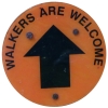
them, find the footpath going off to the right at 90°. If you look closely,
you will see a post bearing an orange with black arrow, Walkers are Welcome
marker, pointing the way (SE 195442).
Watch out for a couple of
large boulders (10/12 feet high) to the left of the path and just beyond
them, find the footpath going off to the right at 90°. If you look closely,
you will see a post bearing an orange with black arrow, Walkers are Welcome
marker, pointing the way (SE 195442).
The path descends the hill,
passing another Walkers are Welcome sign, then curves right down some crude
steps.
You pass a sign for
Ackroyd’s Wood.
The path emerges from the
woods down some stone steps to a road (SE 195448) (West Chevin Road). Turn
right along the road, then first right again, along Birdcage Walk, just
before going over the main A660.
Along Birdcage Walk, you
will eventually come to the footbridge to retrace your steps into Otley.
If you need to buy any
hiking equipment/clothing before your trip see the Hiking
Store
All information on this
site is given in good faith and no liability is accepted in respect of any
damage, loss or injury which might result from acting on it.
|


.jpg)
.jpg)
.jpg)