
|
|
|
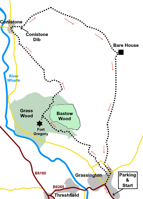
To view route as a dynamic Ordnance Survey map click here. Introduction: This walk takes you on a circular route through Grass Wood to the pretty village of Conistone, leaving it via the dramatic Conistone Dib and returning to Grassington via Bare House. Grass
Wood is managed by the Yorkshire Wildlife Trust and is a Site of Special
Scientific Interest (SSSI). The ground is carboniferous limestone and the
tree cover, which is largely a twentieth century planting, is gradually
being replaced with more appropriate species, ash,
wych elm, oak and hazel. The woods are renowned for their diverse
flora and bird life, although I visited in late February so did not get the
best of this. However,
my main reason for taking the route I did through the woods was to see Fort
Gregory the site of an ancient Brigantean settlement. The
absence of leaves on the trees enables glimpses of the view from there and
you could see why they built it where they did. There is also a site of a
prehistoric settlement although as is the case with many of these things,
there is little to see for the untrained eye. There
are stunning views beyond Grass Wood en route to Conistone, although I did
not have the clearest of days. Kilnsey Crag was clearly visible. Conistone
is an attractive village the lordship of which was bought by villagers in
1583. This would have given them control of local farming and mining as
opposed to being beholden to a lord of the manor. As
you enter the village, you pass Conistone Keld, ‘Keld’ coming from an
Old Norse word ‘Kelda,’ meaning spring. At one time, this was probably
the main source of water for the village. There are three troughs to collect
the water and a cobbled area in front. The Keld was restored in 2018. The
centre of Conistone has a triangular walled ‘island’ where there is some
seating; handy for a picnic. The
route continues up Conistone Dib, which also featured in my Linton and
Kilnsey Circular and Conistone to Mosedale Scar walks. This dramatic gorge
was carved out by glacial melt water after the last ice age. It is now dry,
as is the valley beyond known as Gurling Trough. There are a couple of
awkward ‘steps’ of limestone to ascend, which are likely to be slippery
if wet. Finally,
before returning to Grassington, the route climbs to the isolated, now
virtually derelict farmhouse, Bare House, the highest point of the walk. It
was occupied until the 1960s and known locally as Barras apparently. It must
have been a lonely existence. The building still looks remarkably robust and
no doubt it is only the absence of services and access that prevent it being
turned into someone’s country retreat. It is worth mentioning that this walk can be very muddy in places, so gaiters are recommended after wet weather. There is a moderately steep climb up to Bare House and a bit of awkward footwork in Conistone Dib so I have given amber marking for the middle section but it is marginal. The
walk starts from the pay and display car park at the National Park
Information Centre Grassington. To
get there, follow the B6265 north from Skipton and turn north east at
Thresfield. The road turns sharp right at the entrance to the village and
the car park is after 100 yards or so on the right. It is hardly worth
trying to park in the village itself as it gets quite busy especially in
peak season and parking is limited. Start: Exit the car park and turn left (SE 003638). On reaching the main street, turn right but stay to the left hand side of the market square. After about two hundred and fifty yards, turn left along Garrs End Lane. Turn right as it meets Moody Sty Lane – still Garrs End Lane. On reaching the junction with Bull Ing Lane keep straight ahead along the narrow lane. This is Cove Lane but it is not marked.
After just over a quarter of a mile, reach a ‘T’ junction with a two way public footpath fingerpost (SD 999648). Turn left. The track enters a long narrow field. At the end of it, enter a larger field with a barn on the right. Bear right to a gated stile and cross into Grass Wood, where there is an information panel.
Follow the main path to the right of the information board. When you come to a fork, where a yellow arrow points right, ignore the arrow and fork left. You need to get this correct, as otherwise you will miss the prehistoric settlement site (marked with a notice board) and Fort Gregory.
Follow the path until you reach steps on the left at SD 988655. Climb these to see the site of the fort.
Return to the path and go left. Arrive at a four way fingerpost and take the direction for Bastow Wood. Pass another information board and go over a step stile. Shortly after this, the path splits. Keep left, along the broader track. Leaving the area of the woods, keep straight ahead to a gateway. Do not go through but turn left (SD 993661).
Follow this path to the road at Conistone and turn right, shortly passing Conistone Keld. Continue to the centre of the village and at the triangular ‘island’, turn right (SD 981675).
Follow the path through Conistone Dib and up the wider valley beyond for about a third of a mile. Look out on the right for a three way fingerpost and turn right following the fingerpost for ‘Grassington’ (SD 990679).
Arrive at a gated step stile, with a three way fingerpost. Cross and take the left hand fork. [Should you want a quicker route back to Grassington, take the right fork.]
Go through a gateway and the path bears right to a gated slit stile. The path now leads to a gate in the top right hand corner of the field. There are two routes on the latest OS map, the green Right of Way route and a black dotted path. I followed the black dotted path, this being marginally more direct but they lead to the same point. Go through the gate and bear right to follow the wall, to another gateway. Take the obvious path up the hill. You will pass to the left of a spring and water ‘basin’ (SE 004671). As you crest the hill, you will see Bare House (SE 005669). Go through the gate to its right, then bear right following the obvious path.
As the path closes on a wall and splits, keep right and cross a step stile. There is a three way fingerpost. Follow ‘Grassington’. Cross over a broad track, keeping straight ahead. The route to Grassington is obvious and you can see the village ahead. Eventually, join a walled track and follow it to the tarmac lane and turn left (Bank Lane). Pass the Methodist church and continue until you reach the top of the main street, by the village hall. Turn right to retrace your steps to the car park. If you need to buy any hiking equipment/clothing before your trip see the Hiking Store All information on this site is given in good faith and no liability is accepted in respect of any damage, loss or injury which might result from acting on it.
| | |||||||||||||||||

.jpg)
.jpg)
.jpg)
%20Looking%20towards%20Threshfield%20&%20Malham%20Moor.jpg)
%20View%20towards%20Grass%20Wood.jpg)
%20View%20from%20Grass%20Wood%20to%20Barden%20Moor.jpg)
%20Site%20of%20prehistoric%20settlement.jpg)
%20Fort%20Gregory%20(part).jpg)
%20View%20emerging%20from%20Grass%20Wood.jpg)
%20View%20along%20White%20Nook.jpg)
%20Path%20descending%20to%20Conistone.jpg)
%20River%20Wharfe.jpg)
%20Conistone%20Keld.jpg)
%20Entry%20to%20Conistone%20Dib.jpg)
%20Inside%20Conistone%20Dib.jpg)
%20View%20up%20Wharfedale.jpg)
%20View%20to%20Conistone%20Moor.jpg)
%20First%20sight%20of%20Bare%20House.jpg)
%20Front%20of%20Bare%20House.jpg)