|
Horton-in-Ribblesdale and Upper Ribblesdale
Starting point and OS Grid reference: 
Car
park in Horton-in-Ribblesdale (SD 808726)
|
Ordnance Survey Map
OL2
Yorkshire Dales Southern and Western Areas.
Buy
this map from
List
of OS Maps
Note: If you use OS Maps on-line, you can download this route via this
link.
| |
Distance: 9.8
miles
|
Date of Walk: 28 January 2012
| |
Ascent:
Descent:
See Walking Time Calculator
|
1242ft (379m)
1245ft (379m)
| |
Traffic
light rating: 
(For explanation see My
Walks page)
| |


For advice on .gpx files see
My Walks page
|

Click
the PDF logo above to give a printable version of this walk without the
photos.
|
To
view route as a dynamic Ordnance Survey
map click here.
Introduction:
Horton-in-Ribblesdale is well known
as the starting point for the Three Peaks walk (Pen-y-ghent, Whernside and
Ingleborough) and as a centre for cavers as there are lots of potholes. Most
walkers who visit, if not undertaking the complete Three Peaks walk, come to
climb Pen-y-ghent (see my Pen-y-Ghent and Plover Hill
walk).
This walk however is a lower level walk to
upper Ribblesdale which incorporates good views of all three of the Three
Peaks, some dramatic water features and interesting bridges, not least
“God’s Bridge”. It takes you across wide expanses of rolling moorland
and along part of the Pennine Way. Although it cannot be said that the walk
is completely flat, its undulations do not justify anything more than
“green traffic light” ratings. The route is mostly on easy to follow
broad tracks.
I have described this walk on an
anti-clockwise basis so that if, from about
2 /3 of the way round at High Birkwith, you
wish to complete the walk more quickly by road, you can.
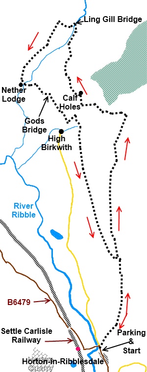
The walk starts at the main car park close to
the Crown Hotel on the B 6479 at Horton-in-Ribblesdale (SD 808726). At
peak times you will find this very busy because Horton is the starting point
where entrants “clock in” for the Three Peaks Challenge. Horton is also
accessible via train from the Settle Carlisle route.
Start:
Turn left out of the car park and at the Crown Hotel, turn right through its
car park. At the back of the Crown Hotel to the left s a track indicated by
a fingerpost (SD 808727). This is Harber Scar Lane, part of the Pennine and
Ribble Way footpath routes. This is quite a rough, broad, walled lane.
After just over a mile, it bends sharp left
at Sell Gill Beck (SD 812744) then after going through a gate enters more
open country. Ignore a fingerpost on the left for Birkwith and stay on the
main track.
%20View%20along%20Harber%20Scar%20Lane.jpg)
%20Pen-y-ghent.jpg)
%20View%20to%20Horton%20Quarry.jpg)
When you come to another gate crossing the
track at a three way fingerpost (SD 813772), take the left hand path for Old Ing ½ mile.
%20Ingleborough.jpg)
Go through a metal gate with a ruined barn on
the left and stay on the main track. As this joins another broad track
joining from your right, turn left. There is a fingerpost confirming you are
on the Pennine way. To the left is the farm of Old Ing.
Just past the farm is a three way fingerpost
at a junction of tracks (SD 805774), turn right for Cam End. After about 200
yards at SD 804776 there is a ladder stile on the right, over which is the
dramatic sight of a waterfall cascading into the Calf Holes cave system.
Take great care not to do the same!
%20Cascade%20into%20Calf%20Holes.jpg)
Stay on your original route and the next
dramatic sight is Ling Gill, a limestone gorge on the left which is a nature
reserve because it is a small upland woodland and the steepness of the gorge
has prevented animals from grazing the plants. This is not open to the
public. I was amused by the
instruction on one of the signs which said to “Please see the back of the
sign for further important information”. Given its proximity to the edge
of the gorge, I can only say “at your own risk”!!
%20Ling%20Gill%20Bridge.jpg)
Beyond Ling Gill is Ling Gill bridge (SD
803789) which, according to the embedded ancient stone, was built in 1776
although it has obviously had some TLC since. Cross the bridge and follow
the line of the wall on the left until you come to a ruined barn. Just past
this, cross the stile, following the fingerpost to Nether Lodge
(SD 800790).
Follow the wall on the left until you see a
gate on the right. You do not go through it but at this point, the path
veers away to the right and to a stile. Cross the stile. The valley now
drops away to the left but you bear slightly right to a fence line which you
follow to a stile in the corner. There are some yellow arrows pointing the
way.
Cross the stile and follow the wall on your
left crossing a stile over a fence until you see Nether Lodge farm (SD
793778). The path descends to a three way finger post. Turn left signed for
Birkwith, crossing the footbridge and stay on the clear main track. This
leads to God’s Bridge over Brow Gill Beck (SD 798776). Go through the
gateway but before you do, walk briefly to the stream to the left of the
gate to see the huge slab of rock bridging the beck which gives God’s
bridge its name.
%20Gods%20Bridge.jpg)
Cross God’s Bridge and follow the line of
the wall on the right.
Pass a finger post for High Birkwith but stay
on the main track until it reaches a broad tarmac track by a large unusually
shaped stone (SD 802770). If you want to make the return journey to Horton
by road, turn right here (you will see the start of the road) - otherwise
turn left. As you reach another strange stone just before a wall, turn
right.
As you reach the end of a wood, follow the
track as it goes left through a gateway with a stile at the side. Look out
for a large isolated rock about 150 yards on the right and bear off right to
follow the line of the rocky scar (SD 804769). After about 2/3
mile, the path turns right . There is a large triangular rock. Pass by this.
As you approach a wall, the path curves round to the left and down to a
short ladder stile and a little wooden bridge over the stream (SD 804765).
Climb the bank at the other side and over the
brow of the hill bearing left until you come to a broad track. Turn right
following the line of the scar once more.
It is now a case of just following the main
track, crossing a ladder stile by a concrete water tank, through several
gateways (ignoring some fingerposts on the right) until you get to a ruined
cottage (SD 801744). Pass to the right of it, through the wall immediately
after it and then turn left over the ladder stile. When you reach the same
broad track on which you began your outward journey, turn right and retrace
your steps to Horton.
If
you need to buy any hiking equipment/clothing before your trip see the Hiking
Store
All information on this
site is given in good faith and no liability is accepted in respect of any
damage, loss or injury which might result from acting on it.
|


.jpg)
.jpg)
.jpg)